
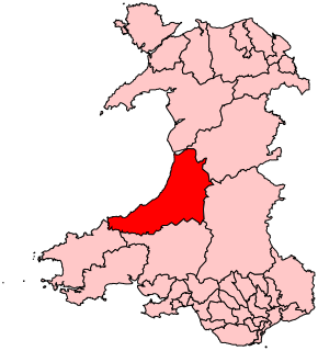
Dyfed is a preserved county in southwestern Wales. It is a mostly rural area with a coastline on the Irish Sea and the Bristol Channel.

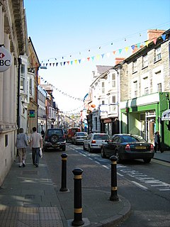
Ceredigion is a county in the west of Wales, corresponding to the historic county of Cardiganshire. During the second half of the first millennium Ceredigion was a minor kingdom. It has been administered as a county since 1282. Ceredigion is considered a centre of Welsh culture and more than half the population can speak Welsh. The county is mainly rural with over 50 miles (80 km) of coastline and a mountainous hinterland. The numerous sandy beaches and the long-distance Ceredigion Coast Path provide excellent views of Cardigan Bay.

Borth, is a village and seaside resort in Ceredigion, Mid Wales, 7 miles (11 km) north of Aberystwyth on the Ceredigion Coast Path. The community includes the settlement of Ynyslas. The population was 1,399 in 2011. From being largely Welsh-speaking, the village has become anglicised: over 54 per cent of its residents were born in England. According to both the 1991 and 2001 censuses, 43 per cent of the residents of Borth were primarily Welsh-speakers.
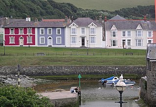
Aberaeron, previously anglicised as Aberayron, is a town, a community, and an electoral ward, between Aberystwyth and Cardigan, in Ceredigion, Wales. Ceredigion County Council offices are in Aberaeron. The name of the town is Welsh for mouth of the Aeron, derived from the Middle Welsh aer, "slaughter", which gave its name to Aeron, who is believed to have been a Welsh god of war.
Cardigan is both a town and a community in the county of Ceredigion, Wales. Positioned on the tidal reach of the River Teifi at the point where Ceredigion meets Pembrokeshire, Cardigan was the county town of the historic county of Cardiganshire. Cardigan is the second-largest town in Ceredigion. The largest town, Aberystwyth, is one of the two administrative centres; the other is Aberaeron.

Lampeter is a town, community and electoral ward in Ceredigion, Wales, at the confluence of the Afon Dulas with the River Teifi. It is the third largest urban area in Ceredigion, after Aberystwyth and Cardigan, and has a campus of the University of Wales Trinity Saint David. At the 2011 Census, the population was 2,970. Lampeter is the smallest university town in the United Kingdom. The university adds approximately 1,000 people to the town's population during term time.

Mid Wales or Central Wales refers to a region of Wales, encompassing its midlands, in-between North Wales and South Wales. The Mid Wales Regional Committee of the Senedd covered the unitary authority areas of Ceredigion and Powys and the area of Gwynedd that had previously been the district of Meirionnydd. A similar definition is used by the BBC. The Wales Spatial Plan defines a region known as "Central Wales" which covers Ceredigion and Powys. If Mid Wales is classed as Ceredigion and Powys, the area would be 6,962 square kilometres (2,688 sq mi).

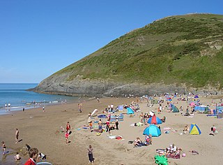
Aberporth is a Welsh coastal village, local-government community and electoral ward in Ceredigion. The population at the 2001 Census, was 2,485, of whom 49 per cent could speak the Welsh language. At the 2011 Census, the population of the community was 2,374 and of the village 1241. Aberporth's beaches have earned Blue Flag status.
Ceredigion is a parliamentary constituency represented in the House of Commons of the UK Parliament. Created in 1536, the franchise expanded in the late 19th century and on the enfranchisement of women. Its boundaries remained virtually unchanged until 1983. From 1536 until 1885 the area had two seats : a county constituency (Cardiganshire) comprising the rural areas, the other the borough constituency known as the Cardigan District of Boroughs comprising a few separate towns; in 1885 the latter was abolished, its towns and electors incorporated into the former, reduced to one MP. The towns which comprised the Boroughs varied slightly over this long period, but primarily consisted of Cardigan, Aberystwyth, Lampeter and Adpar, the latter now a suburb of Newcastle Emlyn across the Teifi, in Carmarthenshire.
West Wales is not clearly defined as a particular region of Wales. Some definitions of West Wales include only Pembrokeshire, Ceredigion and Carmarthenshire, which historically comprised the Welsh principality of Deheubarth and was called "South West Wales" in the Nomenclature of Territorial Units for Statistics (NUTS). Other definitions may include Swansea and Neath Port Talbot but exclude Ceredigion, although this definition may also be described as South West Wales.The "West Wales and the Valleys" NUTS area includes more westerly parts of North Wales.
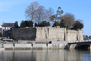
Cardigan Castle is a castle overlooking the River Teifi in Cardigan, Ceredigion, Wales. It is a Grade I listed building. The castle dates from the late 11th-century, though was rebuilt in 1244. Castle Green House was built inside the castle walls in the early 1800s. After falling into disrepair the castle was restored in the early 2000s and opened to the public in 2015. It is owned by Ceredigion County Council and now includes a heritage centre and open-air concert facilities.
Beulah is a small village, wider community and electoral ward located halfway between the market town of Newcastle Emlyn and the seaside resort of Aberporth in Ceredigion, Wales.

Ceredigion County Council is the governing body for the county of Ceredigion, since 1996 one of the unitary authorities of Wales.

Ceredigion is a constituency of the Senedd. It elects one Member of the Senedd by the first past the post method of election. It is also one of eight constituencies in the Mid and West Wales electoral region, which elects four additional members, in addition to eight constituency members, to produce a degree of proportional representation for the region as a whole.
The Ceredigion Coast Path is a waymarked long distance footpath in the United Kingdom, on the coast of Ceredigion, Wales. It is 65 miles (105 km) in length, running along the coast of Cardigan Bay from Cardigan (52.0810°N 4.6608°W) to Ynyslas (52.5271°N 4.0495°W).

Aberystwyth is a university town and community in Ceredigion, Wales. Located in the historic county of Cardiganshire, Aberystwyth means "the mouth of the Ystwyth". In one form or another, Aberystwyth University has been a major educational location in Wales since the establishment of University College Wales in 1872.
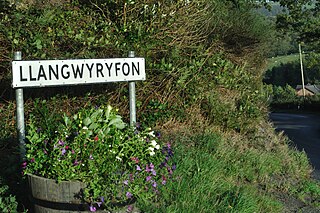
Llangwyryfon is a village and community in the county of Ceredigion, Wales. It lies on the B4576 about 8 miles to the south and east of Aberystwyth. The village lies in the valley of the River Wyre and contains the roadbridge where the B4576 crosses the Wyre downstream of which lies the confluence of the rivers Beidiog and the Wyre. The name Llangwyryfon derives from the tale of Saint Ursula to whom the village church is dedicated. Llan is Welsh for church and the gwyryddon are the 11,000 virgins who Ursula was martyred along with.

Dyffryn Arth is a community in the county of Ceredigion, Wales, and is 66.8 miles (107.5 km) from Cardiff and 178.4 miles (287.1 km) from London. In 2011 the population of Dyffryn Arth was 1174 with 49.7% of them able to speak Welsh. It includes the villages of Aberarth, Pennant, Moelfryn and Cross Inn.
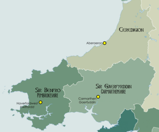
Ceredigion District Council was formed on local government re-organisation in Wales in 1974. Its boundaries were identical to those of the former Cardiganshire County Council which was abolished when that council, together with Carmarthenshire County Council and Pembrokeshire County Council were merged to form Dyfed County Council.
Troedyraur is a small village, wider rural community and electoral ward in Ceredigion, Wales. The community consisting of several small villages, the population as of the 2011 UK Census was 1,310.

