
Ceredigion is a principal area of Wales, corresponding to the historic county of Cardiganshire. During the second half of the first millennium Ceredigion was a minor kingdom. It has been administered as a county since 1282. Ceredigion is considered a centre of Welsh culture and more than half the population can speak Welsh. The county is mainly rural with over 50 miles (80 km) of coastline and a mountainous hinterland. The numerous sandy beaches and the long-distance Ceredigion Coast Path provide excellent views of Cardigan Bay.

University of Wales, Lampeter was a university in Lampeter, Wales. Founded in 1822, and incorporated by royal charter in 1828, it was the oldest degree awarding institution in Wales, with limited degree awarding powers since 1852. It was a self-governing college of the University of Wales from 1972 until its merger with Trinity University College in 2010 to form the University of Wales Trinity Saint David.
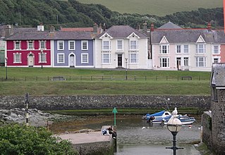
Aberaeron, previously anglicised as Aberayron, is a town, a community and an electoral ward, situated between Aberystwyth and Cardigan in Ceredigion, Wales. Ceredigion County Council offices are based in Aberaeron. The name of the town is Welsh, translating to mouth of the Aeron, derived from the Middle Welsh aer, "slaughter", which gave its name to Aeron, who is believed to have been a Welsh god of war.
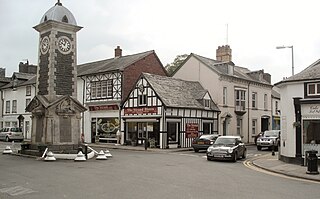
Rhayader is both a market town and a community and an electoral ward in Powys, Wales, within the historic county of Radnorshire. The town is 20 miles (32 km) from the source of the River Wye on Plynlimon, the highest point of the Cambrian Mountains, and is located at the junction of the A470 road and the A44 road 13 miles (21 km) north of Builth Wells and 30 miles (48 km) east of Aberystwyth.

Lampeter is a town, community and electoral ward in Ceredigion, Wales, at the confluence of the Afon Dulas with the River Teifi. It is the third largest urban area in Ceredigion, after Aberystwyth and Cardigan, and has a campus of the University of Wales Trinity Saint David. At the 2011 Census, the population was 2,970. Lampeter is the smallest university town in the United Kingdom. The university adds approximately 1,000 people to the town's population during term time.

Tregaron is an ancient market town in Ceredigion, Wales, astride the River Brenig, a tributary of the River Teifi. Tregaron is 11 miles (18 km) northeast of Lampeter. According to the 2011 Census, the population of the ward of Tregaron was 1,213 and 67% of the population could speak Welsh. Tregaron is a community covering 86 square kilometres. Two-thirds of the population were born in Wales.

Redmarshall is a village and civil parish in the borough of Stockton-on-Tees and ceremonial county of County Durham, England. The population as of the 2011 census was 287. Redmarshall is situated to the west of Stockton-on-Tees, just north of the A66 road which is one of the main trunk routes through Teesside. It is home to the Church of Saint Cuthbert and a pub called The Ship. It has a green in the centre and roads such as Church Lane, Coniston Crescent and Windermere Avenue, named after waters in the Lake District. Ferguson Way is the newest addition to the village. A small wood is a short way out of the village and down a bank past Ferguson Way. There is a new housing estate called the langtons being built on the old remains of the mains care home.

Maentwrog is a village and community in the Welsh county of Merionethshire, lying in the Vale of Ffestiniog just below Blaenau Ffestiniog, within the Snowdonia National Park. The River Dwyryd runs alongside the village. Its population of 585 in 2001 increased to 631 at the 2011 Census. The Community of Maentwrog includes the village of Gellilydan.
Shirenewton is a village and community in Monmouthshire, south east Wales. It is located 3 miles due west of Chepstow, 5 miles (8 km) by road. The village stands around 500 feet above sea level, and has extensive views of the Severn Estuary and Bristol Channel. The population of the village and the conjoined village of Mynydd-bach was 657 in 2011.

Cribyn is a small village in Ceredigion, Wales, about 7 miles (11 km) north of Lampeter and with the villages of Troed y Rhiw, Mydroilyn and Dihewyd to the north.

Ystrad Meurig is a village and community in Ceredigion, Wales. It lies on the B4340 road northwest of the town of Tregaron, on the edge of the Cambrian Mountains.
The Carmarthen–Aberystwyth line was originally a standard-gauge branch line of the Great Western Railway (GWR) in Wales, connecting Carmarthen and Aberystwyth.

Llannon is a small village and community in the county of Carmarthenshire, Wales. It is located on the A476 road 11 miles south east of the county town, Carmarthen, between Tumble and Swiss Valley.
The Lampeter, Aberayron and New Quay Light Railway was an independent branch line railway in south west Wales. It connected Aberayron to the former Manchester and Milford Railway line at Lampeter; New Quay was never reached.

Lampeter is an unincorporated community and census-designated place (CDP) in West Lampeter Township, Lancaster County, Pennsylvania, United States. As of the 2010 census it had a population of 1,669. It is a suburb of Lancaster and has a ZIP code of 17537. The community was named after Lampeter, in Wales.

Pencarreg is a village and community located in Carmarthenshire, Wales, 4 miles (6.4 km) to the south-west of Lampeter.

Crugybar is a village in Carmarthenshire located between Talley and Pumsaint. It is roughly of equal distance from Lampeter, Llandovery and Llandeilo. It is within the parish of Llanwrda.
Lampeter railway station, on the Carmarthen to Aberystwyth Line in Wales, was built to serve the town of Lampeter. It opened in 1866, six years after the line, which reached Aberystwyth in August 1867.

Silian, originally Sulien, is a village in the valley of the River Teifi, Ceredigion, Wales. It is located approximately two miles north-west of Lampeter, on a minor road connecting Pont Creuddun on the A482, and Glan Denys on the A485.

New Inn is a small village located in Carmarthenshire, Wales with a population of 348. It is situated along the A485 A road between Llanllwni and Gwyddgrug, approximately four miles from the village of Pencader. It is a linear settlement consisting of around sixty houses and a chapel.

