This page is based on this
Wikipedia article Text is available under the
CC BY-SA 4.0 license; additional terms may apply.
Images, videos and audio are available under their respective licenses.

The Royal Marsden NHS Foundation Trust is an NHS Foundation Trust which operates the Royal Marsden Hospital facilities on two sites:
Babine Lake Marine Provincial Park is a provincial park in British Columbia, Canada. The park was established by Order-in-Council in 1993, comprising two sites at Pendleton Bay totalling 36.9 hectares. Another was established in the same year at Smithers Landing, comprising approximately 157.8 hectares. Three more sites were added in 2001, Hook (Deep) Bay, Pierre Creek, Pinkut Creek and Sandpoint. All sites combined comprise approximately 492 hectares.
Shuswap Lake Marine Provincial Park is an 896-hectare provincial park in British Columbia, Canada, comprising 991 ha. The Park has a variety of amenities including boat launch ramps, picnic areas, and 27 campsites around the perimeter of Shuswap Lake. The lake's name and that of the surrounding Shuswap Country is from the Shuswap people (Secwepemc), the most northern of the Salishan speaking people.
Damery Road Section is a 0.5-hectare (1.2-acre) geological Site of Special Scientific Interest north of Tortworth, South Gloucestershire, notified in 1974.
Cullimore's Quarry is a 0.9 hectare geological Site of Special Scientific Interest near the village of Charfield, South Gloucestershire, notified in 1974.
Tytherington Quarry is a 0.9 hectare geological Site of Special Scientific Interest near the village of Tytherington, South Gloucestershire, notified in 1989.

Tytherington Down is a 5.9 hectare biological Site of Special Scientific Interest in Wiltshire, England, notified in 1975. The site spans a dry valley some 1 1⁄2 miles (2.4 km) south of the village of Tytherington and 5 miles (8 km) southeast of Warminster.
The Kennet and Lambourn Floodplain is a 22.9 hectare biological Site of Special Scientific Interest in Berkshire and Wiltshire, England, notified in 1996. It comprises seven separate small areas, four in the Kennet Valley and three in the Lambourn Valley. The areas included in the site support particularly large populations of Desmoulin's whorl snail.
Inwood, Warleigh is a 56.9 hectare biological Site of Special Scientific Interest in Wiltshire, notified in 1988.

Brook Brick Pit is a 0.9-hectare (2.2-acre) geological Site of Special Scientific Interest west of Wormley Surrey. It is a Geological Conservation Review site.

North Hall High School is a public four-year comprehensive high school located in the northern portion of Hall County, Georgia, United States, in the foothills of the Appalachian Mountains. North Hall serves the communities of Gainesville, Murrayville, and Clermont, and is located 10 miles north of Gainesville and 15 miles south of Dahlonega.

Horsell Common is a 355-hectare (880-acre) open space in Horsell, near Woking in Surrey. It is owned and managed by the Horsell Common Preservation Society. An area of 152 hectares is a biological Site of Special Scientific Interest and part of the Thames Basin Heaths Special Protection Area.

Mole Gap to Reigate Escarpment is a 1,016.4-hectare (2,512-acre) biological and geological Site of Special Scientific Interest west of Reigate in Surrey. It is a Geological Conservation Review site and a Special Area of Conservation. Part of it is a Nature Conservation Review site, Grade I. Two small private nature reserves in the site are managed by the Surrey Wildlife Trust, Dawcombe and Fraser Down.

Netherside Stream Outcrops is a 2.9-hectare (7.2-acre) geological Site of Special Scientific Interest north-east of Haslemere in Surrey. It is a Geological Conservation Review site.

The Banff Park Museum National Historic Site, located in downtown Banff, Alberta, is an exhibition space associated with Banff National Park. The museum was established in 1895 to house an exhibit of taxidermy mounted specimens of animals, plants and minerals associated with the park. The museum building, constructed in 1903 to the design of territorial government engineer John Stocks, is an early example of the rustic style of architecture that was becoming popular in the parks of North America.
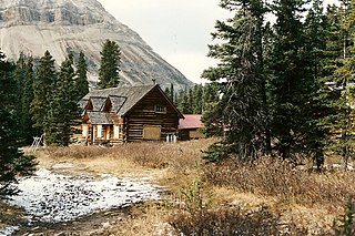
The Skoki Ski Lodge National Historic Site of Canada was built in 1930-31 in the Skoki Valley of Canada's Banff National Park. Built by local members of the Ski Club of the Canadian Rockies, the lodge was the first commercial building built specifically to serve skiers in Canada, and possibly in North America. Design and construction work was carried out by local outfitter and builder Earl Spencer with help from Spud White and Victor Kutschera. The lodge was progressively expanded through 1936 by outfitter, guide and log home builder Jim Boyce who was also managing the Lodge the time. It has remained unaltered since that time. The Lodge operates throughout the year.

Pitstone Hill is a 22.9 hectare biological Site of Special Scientific Importance east of Pitstone in Buckinghamshire. It is in the Chilterns Area of Outstanding Natural Beauty, and is crossed by the Ridgeway National Trail.
Aston Clinton Ragpits is a 2.9 hectare biological Site of Special Scientific Interest in Aston Clinton in Buckinghamshire. It is a former chalk quarry, which is now a nature reserve managed by the Berkshire, Buckinghamshire and Oxfordshire Wildlife Trust. It is in the Chilterns Area of Outstanding Natural Beauty.


