
Sedimentary rocks are types of rock that are formed by the deposition and subsequent cementation of mineral or organic particles on the floor of oceans or other bodies of water at the Earth's surface. Sedimentation is the collective name for processes that cause these particles to settle in place. The particles that form a sedimentary rock are called sediment, and may be composed of geological detritus (minerals) or biological detritus. Before being deposited, the geological detritus was formed by weathering and erosion from the source area, and then transported to the place of deposition by water, wind, ice, mass movement or glaciers, which are called agents of denudation. Biological detritus was formed by bodies and parts of dead aquatic organisms, as well as their fecal mass, suspended in water and slowly piling up on the floor of water bodies. Sedimentation may also occur as dissolved minerals precipitate from water solution.

Avon Valley is a national park in Western Australia, 47 kilometres northeast of Perth. It was named after the Avon River which flows through it. The area is an undulating plateau with the sides of the valley steeply sloping back to the river approximately 200 metres (660 ft) below. The area contains granite outcrops and a mix of soil types including loams, gravels and lateritic sands.

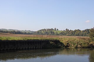
The Kennet and Avon Canal is a waterway in southern England with an overall length of 87 miles (140 km), made up of two lengths of navigable river linked by a canal. The name is commonly used to refer to the entire length of the navigation rather than solely to the central canal section. From Bristol to Bath the waterway follows the natural course of the River Avon before the canal links it to the River Kennet at Newbury, and from there to Reading on the River Thames. In all, the waterway incorporates 105 locks.
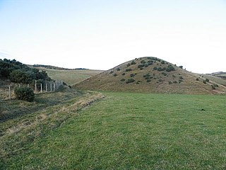
A kame is a glacial landform, an irregularly shaped hill or mound composed of sand, gravel and till that accumulates in a depression on a retreating glacier, and is then deposited on the land surface with further melting of the glacier. Kames are often associated with kettles, and this is referred to as kame and kettle topography. The word kame is a variant of comb, which has the meaning "crest" among others. The geological term was introduced by Thomas Jamieson in 1874.

Conglomerate is a coarse-grained clastic sedimentary rock that is composed of a substantial fraction of rounded to subangular gravel-size clasts, e.g., granules, pebbles, cobbles, and boulders, larger than 2 mm (0.079 in) in diameter. Conglomerates form by the consolidation and lithification of gravel. Conglomerates typically contain finer grained sediment, e.g., either sand, silt, clay or combination of them, called matrix by geologists, filling their interstices and are often cemented by calcium carbonate, iron oxide, silica, or hardened clay.

Clastic rocks are composed of fragments, or clasts, of pre-existing minerals and rock. A clast is a fragment of geological detritus, chunks and smaller grains of rock broken off other rocks by physical weathering. Geologists use the term clastic with reference to sedimentary rocks as well as to particles in sediment transport whether in suspension or as bed load, and in sediment deposits.
Newton St Loe SSSI is a geological Site of Special Scientific Interest (SSSI) close to the River Avon, near the village of Newton St Loe in Bath and North East Somerset. It was notified on September 1992.

Bourne SSSI, Avon is an 8.47 hectare geological Site of Special Scientific Interest near the village of Burrington, North Somerset, notified in 1992.

In sedimentology imbrication refers to a primary depositional fabric consisting of a preferred orientation of clasts such that they overlap one another in a consistent fashion, rather like a run of toppled dominoes. Imbrication is observed in conglomerates and some volcaniclastic deposits.
Frankenbury Camp is the site of an Iron Age univallate hillfort located in Hampshire. The site is on a very slight promontory overlooking the Avon Valley on the north-western edge of the New Forest. The fort encloses approximately 11 acres. It has very steep natural slopes on the west and south sides. The northeast sides are defended by a simple rampart and ditch. The original entrance on the southeast corner has since been widened. It is listed as a scheduled ancient monument no.122. The site is currently pasture, and part of Folds Farm, for the most part, although the earthworks themselves are lined with trees and the south and western parts are now encroached by woodland. Various archaeological relics have been found in the area:

Gorley Hill is the site of a former Iron Age promontory hillfort located in Hampshire in the United Kingdom.

A cobble is a clast of rock defined on the Udden–Wentworth scale as having a particle size of 64–256 millimeters (2.5–10.1 in), larger than a pebble and smaller than a boulder. Other scales define a cobble's size in slightly different terms. A rock made predominantly of cobbles is termed a conglomerate. Cobblestone is a building material based on cobbles.
The law of included fragments is a method of relative dating in geology. Essentially, this law states that clasts in a rock are older than the rock itself. One example of this is a xenolith, which is a fragment of country rock that fell into passing magma as a result of stoping. Another example is a derived fossil, which is a fossil that has been eroded from an older bed and redeposited into a younger one.
A granule is a clast of rock with a particle size of 2 to 4 millimetres based on the Krumbein phi scale of sedimentology. Granules are generally considered to be larger than sand and smaller than pebbles. A rock made predominantly of granules is termed a granule conglomerate.

A weathering rind is a discolored, chemically altered, outer zone or layer of a discrete rock fragment formed by the processes of weathering. The inner boundary of a weathering rind approximately parallels the outer surface of the rock fragment in which it has developed. Rock fragments with weathering rinds normally are discrete clasts, ranging in size from pebbles to cobbles or boulders. They typically occur either lying on the surface of the ground or buried within sediments such as alluvium, colluvium, or glacial till. A weathering rind represents the alteration of the outer portion of a rock by exposure to air or near surface groundwater over a period of time. Typically, a weathering rind may be enriched with either iron or manganese, and silica, and oxidized to a yellowish red to reddish color. Often a weathering rind exhibits multiple bands of differing colors.

Campden Tunnel Gravel Pit is a 0.2-hectare (0.49-acre) geological Site of Special Scientific Interest in Gloucestershire, notified in 1988. The site is listed in the 'Cotswold District' Local Plan 2001-2011.

West Toodyay was the original location of the town of Toodyay, Western Australia. It is situated in the Toodyay valley, 85 kilometres (53 mi) north east of Perth. The Toodyay valley, discovered by Ensign Robert Dale in 1831, was opened up for settlement in 1836. The original site for the town of Toodyay was determined in 1836 and its boundaries were finalized 1838. The first survey of the town was carried out in 1849. After several serious floods, the decision was made to move the town of Toodyay to higher ground. In 1860, the new town of Newcastle was established 3 miles (4.8 km) further upstream. Newcastle was renamed in 1910 to Toodyay, and the original site became known as West Toodyay.

Holland-on-Sea Cliff is a 0.1 hectare geological Site of Special Scientific Interest in Holland-on-Sea, north-west of Clacton-on-Sea in Essex. It is a Geological Conservation Review site.
Way Group is a geologic group of Lower Cretaceous age located in northern Chile. The sediments of the group deposited in Coloso Basin, a small intra-arc basin made up by a half graben. The now inactive Coloso Basin is elongated along a NNW-SSE oriented axis and has its southwestern border made up by faults.


