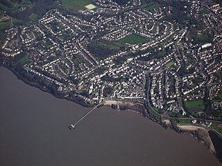
Clevedon is an English town and civil parish in the unitary authority of North Somerset, part of the ceremonial county of Somerset. It recorded a parish population of 21,281 in the United Kingdom Census 2011, estimated at 21,442 in 2019. It lies along the Severn Estuary, among small hills that include Church Hill, Wain's Hill, Dial Hill, Strawberry Hill, Castle Hill, Hangstone Hill and Court Hill, a Site of Special Scientific Interest with overlaid Pleistocene deposits. It features in the Domesday Book of 1086. Clevedon grew in the Victorian period as a seaside resort and in the 20th century as a dormitory town for Bristol.
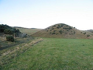
A kame is a glacial landform, an irregularly shaped hill or mound composed of sand, gravel and till that accumulates in a depression on a retreating glacier, and is then deposited on the land surface with further melting of the glacier. Kames are often associated with kettles, and this is referred to as kame and kettle topography. The word kame is a variant of comb, which has the meaning "crest" among others. The geological term was introduced by Thomas Jamieson in 1874.

Clevedon Court is a manor house on Court Hill in Clevedon, North Somerset, England, dating from the early 14th century. It is now owned by the National Trust. It is designated as a Grade I listed building.

Clevedon Pier is a seaside pier in the town of Clevedon, Somerset, England on the east shore of the Severn Estuary. It was described by Sir John Betjeman, as "the most beautiful pier in England" and was designated a Grade I listed building in 2001.

Bilsey Hill is a 3-hectare (7.4-acre) geological Site of Special Scientific Interest south of Blakeney in Norfolk. It is a Geological Conservation Review site and it is in the Norfolk Coast Area of Outstanding Natural Beauty.

Kenn is a small village and civil parish in county of Somerset, England. It falls within the area of the North Somerset unitary authority. It lies on the B3133 road near Clevedon in the North Somerset Levels. The parish has a population of 431.

Briarcroft Pasture is a 1.76 hectare biological Site of Special Scientific Interest in County Durham, England notified in 2004.
The geology of Cheshire in England consists mainly of Triassic sandstones and mudstones. To the north west of Cheshire, these rocks are heavily faulted and the underlying Carboniferous Coal Measures are thrown up. Around the areas of Poynton and Macclesfield, the coal is close to the surface and was easily mined. Below the Coal Measures is the Millstone Grit, which appears towards the Derbyshire border on the flanks of the Peak District dome.

The geology of England is mainly sedimentary. The youngest rocks are in the south east around London, progressing in age in a north westerly direction. The Tees-Exe line marks the division between younger, softer and low-lying rocks in the south east and the generally older and harder rocks of the north and west which give rise to higher relief in those regions. The geology of England is recognisable in the landscape of its counties, the building materials of its towns and its regional extractive industries.

Hans Price (1835–1912) was the architect responsible for much of the development of Weston-super-Mare, in North Somerset, England, during the Victorian era.

The Geology of Yorkshire in northern England shows a very close relationship between the major topographical areas and the geological period in which their rocks were formed. The rocks of the Pennine chain of hills in the west are of Carboniferous origin whilst those of the central vale are Permo-Triassic. The North York Moors in the north-east of the county are Jurassic in age while the Yorkshire Wolds to the south east are Cretaceous chalk uplands. The plain of Holderness and the Humberhead levels both owe their present form to the Quaternary ice ages. The strata become gradually younger from west to east.

Walton Castle is a 17th Century, Grade II listed castle set upon a hill in Clevedon, North Somerset, England, on the site of an earlier Iron Age hill fort.
Raisby Hill Quarry is a Site of Special Scientific Interest in east County Durham, England. It lies just under 2 km east of the village of Coxhoe.

Campden Tunnel Gravel Pit is a 0.2-hectare (0.49-acre) geological Site of Special Scientific Interest in Gloucestershire, notified in 1988. The site is listed in the 'Cotswold District' Local Plan 2001-2011.
Flixton Quarry is a 0.7 hectare geological Site of Special Scientific Interest south-west of Bungay in Suffolk. It is a Geological Conservation Review site.
The geology of the Isle of Man consists primarily of a thick pile of sedimentary rocks dating from the Ordovician period, together with smaller areas of later sedimentary and extrusive igneous strata. The older strata was folded and faulted during the Caledonian and Acadian orogenies The bedrock is overlain by a range of glacial and post-glacial deposits. Igneous intrusions in the form of dykes and plutons are common, some associated with mineralisation which spawned a minor metal mining industry.

Houlder and Monarch Hill Pits is a 0.7-hectare (1.7-acre) geological Site of Special Scientific Interest in Upper Halling in Kent. It is a Geological Conservation Review site.
Stanford Training Area SSSI is part of the British Army Stanford Training Area. It is a 4,678-hectare (11,560-acre) biological and geological Site of Special Scientific Interest north of Thetford in Norfolk. It is a Nature Conservation Review site and part of it is a Geological Conservation Review site. It is also part of the Breckland Special Area of Conservation and Special Protection Area.

Leet Hill, Kirby Cane is a 6.5-hectare (16-acre) geological Site of Special Scientific Interest in Kirby Cane in Norfolk. It is a Geological Conservation Review site.

Glandford is a 9.4-hectare (23-acre) geological Site of Special Scientific Interest west of Sheringham in Norfolk. It is a Geological Conservation Review site and it is in the Norfolk Coast Area of Outstanding Natural Beauty.

