
Bath is a city in the Bath and North East Somerset unitary area in the county of Somerset, England, known for and named after its Roman-built baths. At the 2021 Census, the population was 101,557. Bath is in the valley of the River Avon, 97 miles (156 km) west of London and 11 miles (18 km) southeast of Bristol. The city became a World Heritage Site in 1987, and was later added to the transnational World Heritage Site known as the "Great Spa Towns of Europe" in 2021. Bath is also the largest city and settlement in Somerset.

Bath is a town in Grafton County, New Hampshire, United States. The population was 1,077 at the 2020 census, unchanged from the 2010 census. Now a tourist destination and commuter town for Littleton, the town is noted for its historic architecture, including the Brick Store and three covered bridges. Bath includes the village of Swiftwater and part of the district known as Mountain Lakes.

The River Avon is a river in the south west of England. To distinguish it from a number of other rivers of the same name, it is often called the Bristol Avon. The name 'Avon' is a cognate of the Welsh word afon, meaning 'river'.

The Mendip Hills is a range of limestone hills to the south of Bristol and Bath in Somerset, England. Running from Weston-super-Mare and the Bristol Channel in the west to the Frome valley in the east, the hills overlook the Somerset Levels to the south and the Chew Valley and other tributaries of the Avon to the north. The hills give their name to the local government district of Mendip, which administers most of the area. The higher, western part of the hills, covering 198 km2 (76 sq mi) has been designated an Area of Outstanding Natural Beauty (AONB), which gives it a level of protection comparable to a national park.
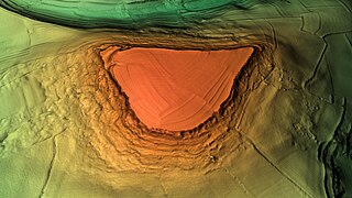
Little Solsbury Hill is a small flat-topped hill and the site of an Iron Age hill fort, above the village of Batheaston in Somerset, England. The hill rises to 625 feet (191 m) above the River Avon, which is just over 1 mile (2 km) to the south, and gives views of the city of Bath and the surrounding area. It is within the Cotswolds Area of Outstanding Natural Beauty.
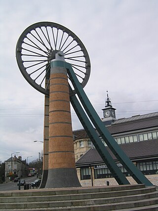
Radstock is a town and civil parish on the northern slope of the Mendip Hills in Somerset, England, about 9 miles (14 km) south-west of Bath and 8 miles (13 km) north-west of Frome. It is within the area of the unitary authority of Bath and North East Somerset. The Radstock built-up area had a population of 9,419 at the 2011 Census.

The Roman Baths are well-preserved thermae in the city of Bath, Somerset, England. A temple was constructed on the site between 60 and 70 AD in the first few decades of Roman Britain. Its presence led to the development of the small Roman urban settlement known as Aquae Sulis around the site. The Roman baths—designed for public bathing—were used until the end of Roman rule in Britain in the 5th century AD. According to the Anglo-Saxon Chronicle, the original Roman baths were in ruins a century later. The area around the natural springs was redeveloped several times during the Early and Late Middle Ages.
The Cohocton River, sometimes referred to as the Conhocton River, is a 58.5-mile-long (94.1 km) tributary of the Chemung River in western New York in the United States. Via the Chemung River, it is part of the Susquehanna River watershed, flowing to Chesapeake Bay. The name "Cohocton" is derived from an Iroquois term, Ga-ha-to, meaning "log floating in the water" or "trees in the water".
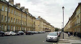
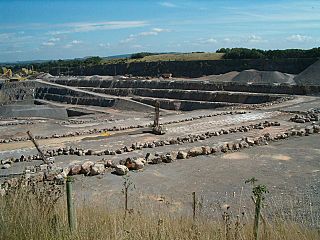
Bath Stone is an oolitic limestone comprising granular fragments of calcium carbonate. Originally obtained from the Combe Down and Bathampton Down Mines under Combe Down, Somerset, England. Its honey colouring gives the World Heritage City of Bath, England its distinctive appearance. An important feature of Bath Stone is that it is a 'freestone', so-called because it can be sawn or 'squared up' in any direction, unlike other rocks such as slate, which form distinct layers.
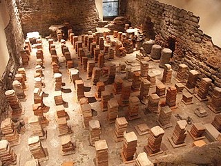
A caldarium was a room with a hot plunge bath, used in a Roman bath complex.
The Chew Valley is an affluent area in North Somerset, England, named after the River Chew, which rises at Chewton Mendip, and joins the River Avon at Keynsham. Technically, the area of the valley is bounded by the water catchment area of the Chew and its tributaries; however, the name Chew Valley is often used less formally to cover other nearby areas, for example, Blagdon Lake and its environs, which by a stricter definition are part of the Yeo Valley. The valley is an area of rich arable and dairy farmland, interspersed with a number of villages.
Banwell Caves are a 1.7-hectare geological and biological Site of Special Scientific Interest near the village of Banwell, North Somerset, England notified in 1963.

Compton Martin Ochre Mine is a 0.85 hectare geological and biological Site of Special Scientific Interest located on the north side of the Mendip Hills, immediately south west of Compton Martin village, Somerset, notified in 1988.
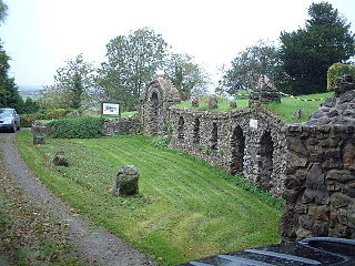
Brown's Folly or Brown's Folly is a folly tower sitting within a 39.9 hectare biological and geological Site of Special Scientific Interest (SSSI) near the village of Bathford in Somerset, notified in 1974: the site itself is known as the Farleigh Down Stone Quarry, and is managed as a nature reserve by the Avon Wildlife Trust (AWT). The tower was built in 1848 and is a Grade II listed building.
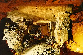
Combe Down and Bathampton Down Quarries make up a 6.22 hectare Site of Special Scientific Interest (SSSI) in Bath and North East Somerset, England, important for its bat population. The disused quarries date from the 17th and 18th centuries and were the source of Bath stone for the city of Bath and elsewhere in the UK. A five-year project to stabilise the quarry workings was largely completed by November 2009.
Hinton Hill, Wellow is a 0.25 hectare geological Site of Special Scientific Interest (SSSI) near the village of Wellow in Somerset, notified in 1996.
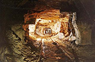
The Somerset Coalfield in northern Somerset, England is an area where coal was mined from the 15th century until 1973. It is part of a larger coalfield which stretched into southern Gloucestershire. The Somerset coalfield stretched from Cromhall in the north to the Mendip Hills in the south, and from Bath in the east to Nailsea in the west, a total area of about 240 square miles (622 km2). Most of the pits on the coalfield were concentrated in the Cam Brook, Wellow Brook and Nettlebridge Valleys and around Radstock and Farrington Gurney. The pits were grouped geographically, with clusters of pits close together working the same coal seams often under the same ownership. Many pits shared the trackways and tramways which connected them to the Somerset Coal Canal or railways for distribution.
The Mendip Hills, (Mendips) in northern Somerset, are the most southerly Carboniferous Limestone uplands in Britain.

The county of Somerset is in South West England, bordered by the Bristol Channel and the counties of Bristol and Gloucestershire to the north, and Wiltshire to the east, Dorset to the south, and Devon to the west. The climate, influenced by its proximity to the Atlantic Ocean and the prevailing westerly winds, tends to be mild, damp and windy.
Bath is a former settlement in Placer County, California. Bath is located 1.5 miles (2.4 km) northeast of Foresthill. It lay at an elevation of 3442 feet.

