Borgergade

Last updated
Borgergade
Borgergade at Sankt Pauls Gade.jpg
Borgergade with one of the Grey Rows of the Nyboder district seen on the right
Length850 m (2,790 ft)
Location Copenhagen, Denmark
Quarter Indre By
Nearest metro station Kongens Nytorv, Østerport
Coordinates 55°41′2.69″N12°35′7.42″E / 55.6840806°N 12.5853944°E / 55.6840806; 12.5853944
Southwest end Gothersgade
Northeast end Store Kongensgade

Borgergade is a street in central Copenhagen, Denmark. It runs from Gothersgade to Store Kongensgade. As one of relatively few streets in central Copenhagen, the street, in its western part, is dominated by modern buildings. The eastern part passes through the Nyboder district.

Contents

History

Foundation of the street

Borgergade originates in the 1649 plan for New Copenhagen, the large area which was included in the fortified city when the old East Rampart along present day Gothersgade was decommissioned and a new one was built in a more northerly direction. According to the plan, the streets in the area were to be named after Danish territorial possessions, royalty and the upper classes. [1] The new district was spaciously planned with long straight streets. The most affluent families settled along Bredgade and Ny Kongensgade while the area around Borgergade and Adelgade catered to a more modest clientele, typically craftsmen and shop-keepers. The buildings were generally half-timbered and relatively small, and living conditions were still considerably better than in the crowded city centre.

Escaping disaster

Christian Gedde's 1757 map of St. Ann's West Quarter: Borgergade is the horizontal street in the bottom of the map Sankt Annae vester kvarter (1757).jpg
Christian Gedde's 1757 map of St. Ann's West Quarter: Borgergade is the horizontal street in the bottom of the map

The neighbourhood escaped both the Great Fires of 1728 and 1795, and was also left largely unharmed by the British bombardment of the city during the Battle of Copenhagen in 1807.

One of the finest buildings in the street was the Mint Master's House. It had been built in 1683 by Royal Mint Master Gregorius Sessemann as his private residence and was inhabited by successive mint masters until 1752. In 1720 the house was fitted with a fine Baroque staircase. A separate apartment was created which was rented by the Russian Ambassador in 1728. In the 1760s the house was extended and adapted once again, reaching its finest state. In 1767, it was acquired by a master mason who lived there until 1803. [2]

Crowding and poverty

Slum Copenhagen slum.jpg
Slum

While Borgergade escaped the direct effects fires and war, they would still have a deep impact on the street. Many people who had been left homeless and ruined by the disasters moved there in search of affordable accommodation, making it increasingly crowded. Gardens and courtyards were built over and extra floors were added on top of existing buildings to make room for the many new residents.

On 26 January 1865, the first public bath house opened in the street after a donation from Carl Joachim Hambro, a banker residing in London, [3] but apart from that sanitation facilities were sparse. [4]

When the Fortifications were decommissioned in the middle of the century, many of the owners moved on to the new residential districts which had sprung up, such as Nørrebro and Vesterbro, and the area around Borgergade developed into one of the worst and most crowded slums in the city with a notorious reputation for poverty, vice and crime.

Condemnation

Demolition work with the Mint Master's House as a backdrop Montmestergarden - demolishions.jpg
Demolition work with the Mint Master's House as a backdrop

In the end, it was decided to condemn the area. Clearing began in the early 1940s but was put on hold in 1943 due to the war. After the Liberation, the work was resumed and the area was built up with modern buildings in the late 1940s and 50s. Two smaller streets, Prinsessegade and Helsingørgade, ceased to exist.

The Mint Master's House in Aarhus Den Gamle By i Arhus 20.JPG
The Mint Master's House in Aarhus

Instigated by Christian Axel Jensen, director of Museum of Copenhagen, the Mint Master's House was dismantled, registered and stored in a shed at Vestre Cemetery. The plan was to re-build it at a later date as part of an open-air museum dedicated to urban architecture which was to complement the rural buildings at Lyngby Open Air Museum but it never materialised. In 1995, The Old Town in Aarhus took over the materials and the house was finally reconstructed in 2009.

Buildings

As a result of the condemnations, the first, western, section of the street is lined with modern buildings. At Dronningens Tværgade, the street passes the south side of Dronningegården, a distinctive residential complex which forms a space round the intersection of Dronningens Tværgade and Adelgade.

A peek of Borgergade between two of the Grey Rows along Raevegade Raevegade - Gra Stokke.jpg
A peek of Borgergade between two of the Grey Rows along Rævegade

The modern buildings finally give way to older buildings and the last section of the street from Fredericiagade passes through the Nyboder district, an area of naval barracks founded by King Christian IV. Both the more famous yellow houses and the younger so-called Grey (or New) Rows, designed by Olaf Schmidth and built between 1886 and 1893, are to be found along the street. The Historicist building at No. 111 was built as a girls' school and later served as a naval cadet academy. It is now known as Bygningskulturens Hus and serve as a centre for historical architecture and cultural heritage.

Cultural references

Borgergade at No. 28 is used as a location at 0:25:27 and again at 0:28:43 in the 1975 Olsen-banden film The Olsen Gang on the Track . [5]

See also

Related Research Articles

<span class="mw-page-title-main">Kronprinsessegade</span> Street in Copenhagen, Denmark

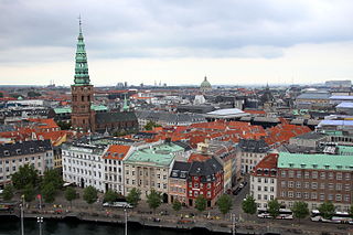
Kronprinsessegade is a street in central Copenhagen, Denmark. Noted for its fine Neoclassical houses, it extends from Gothersgade and runs along the southern boundary of Rosenborg Castle Garden, passing Sølvgade and the Nyboder district of old naval barracks before finally joining Øster Voldgade close to Østerport Station. The David Collection, a museum which displays a large collection of Islamic art as well as Danish and European fine and applied arts, is based at No. 30.

<span class="mw-page-title-main">Dronningegården</span> Residential complex in Copenhagen, Denmark

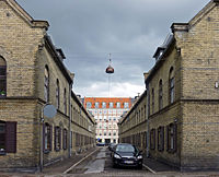
Dronningegården is a Modernist residential complex in central Copenhagen, Denmark, consisting of four L-shaped buildings defining an urban space around the intersection of Adelgade and Dronningens Tværgade. Designed by Kay Fisker in collaboration with C. F. Møller and Svenn Eske Kristensen, it was built between 1943 and 1958, during the transition from Traditionalism to Modernism, as a notable example of Nordic Functionalism.

<span class="mw-page-title-main">Gammel Mønt</span>

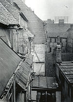
Gammel Mønt is a street in central Copenhagen, Denmark, located one block west of Gothersgade and Rosenborg Castle Garden.

<span class="mw-page-title-main">Dronningens Tværgade</span> Street in Copenhagen, Denmark

Dronningens Tværgade is a street in central Copenhagen, Denmark, which runs from Bredgade to Rosenborg Castle Garden. The street originally formed a link between the King's Garden and the Queen's Garden. With the Odd Fellows Mansion on Bredgade and the central pavilions of the east fringe of the castle garden located at each their end, the street has axial qualities. These are accentuated by the Dronningegården Estate, a Functionalist housing complex from the 1940s, which forms an urban space around the intersection with Adelgade.

<span class="mw-page-title-main">Havnegade</span> Waterfront promenade in central Copenhagen, Denmark

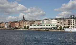
Havnegade is a waterfront promenade in central Copenhagen, Denmark, which runs between Knippelsbro and the mouth of the Nyhavn canal. Most of the street is lined with buildings from the 1860s and 1870s that were constructed as part of the redevelopment of the Gammelholm naval dockyards. It is the only place along Copenhagen's main harbourfront where residential buildings of that age face the water, although older warehouses and other industrial buildings elsewhere have been converted into residential use. The Modernist Bank of Denmark building is located at the western end of the street.

<span class="mw-page-title-main">Toldbodgade</span> Street in Copenhagen, Denmark

Toldbodgade is a street in central Copenhagen, Denmark. It extends north from Nyhavn at the Nyhavn Bridge, continuing Holberggade, passes Sankt Annæ Plads after just one block, and continues straight until it reaches West India Warehouse where it makes a sharp left turn which connects it to Amaliegade, its parallel street, at the rear of the Design Museum.

<span class="mw-page-title-main">Ved Stranden</span>

Ved Stranden is a canal side public space and street which runs along a short section of the Zealand side of Slotsholmen Canal in central Copenhagen, Denmark. It begins at Holmens Kanal, opposite the Church of Holmen, and runs west along the canal for one and a half blocks before widening into a small, triangular space adjacent to Højbro Bridge and Højbro Plads. The name of the street refers to Gammel Strand, 'Old Beach', which it formed part of until 1961.

<span class="mw-page-title-main">Torvegade</span>

Torvegade is the central thoroughfare of Christianshavn in Copenhagen, Denmark, linking the city centre by way of Knippel Bridge with Amagerside Copenhagen at Christmas Møllers Plads. The street crosses Christianshavn Canal at Christianshavns Torv, the central square of the neighbourhood. The last section of the street runs on the embankment that across Stadsgraven.

<span class="mw-page-title-main">Sølvgade</span> Street in Copenhagen, Denmark

Sølvgade is a street in central Copenhagen, Denmark, extending north-west from Borgergade to The Lakes where Fredens Bro connects it to Fredensgade. The section from Kronprinsessegade to Øster Voldgade follows the walled north-eastern margin of Rosenborg Castle Garden and the next section, from Øster Voldgade to the intersection with Farimagsgade, named Sølvtorvet although it is little more than a busy street junction, separates Copenhagen Botanical Garden from Østre Anlæg.

<span class="mw-page-title-main">Store Kongensgade</span> Street in Copenhagen, Denmark

Store Kongensgade is the longest street in central Copenhagen, Denmark. It extends northeast from Kongens Nytorv to Esplanaden, running parallel to Bredgade, where it breaks left, continuing northwest to Grønningen.

<span class="mw-page-title-main">Pilestræde</span>

Pilestræde is a street in central Copenhagen, Denmark. It is a side street to the pedestrianized shopping street Strøget and commonly associated with the newspaper publishing house Berlingske Media, which has its headquarters in the street.

<span class="mw-page-title-main">Søgade, Copenhagen</span>

Vester, Nørre and Øster Søgade is a succession of streets along the eastern side of The Lakes in central Copenhagen, Denmark. The streets run from Gammel Kongevej to the south to the beginning of Østerbrogade at Lille Trianglen in the north. Vester Søgade runs from Gammel Kongevej to Gyldenløvesgade, Nørre Søgade runs from Gyldenløvesgade to Dronning Louises Bro, and Øster Søgade from Dronning Louises Bro to Lille Triangel.

<span class="mw-page-title-main">Adelgade</span> Street in Copenhagen, Denmark

Adelgade is a street in central Copenhagen, Denmark. It runs from Gothersgade in the south to Sankt Pauls Plads with St. Paul's Church in the north. The first half of the street is dominated by modern buildings while its last section passes through the Nyboder district.

<span class="mw-page-title-main">Rigensgade</span> Street in Copenhagen, Denmark

Rigensgade is a street in central Copenhagen, Denmark. It links Sølvgade in the west with Øster Voldgade in the east. An underpass for pedestrians link the beginning of the street with Rosenborg Castle Gardens on the other side of Sølvgade. Notable buildings include the former Garrison Hospital. and the Methodist Jerusalem's Church.

<span class="mw-page-title-main">Fredericiagade</span> Street in Copenhagen, Denmark

Fredericiagade is a street in central Copenhagen, Denmark. It runs from Amaliegade in the south to Rigensgade in the north.

<span class="mw-page-title-main">Olfert Fischers Gade</span> Street in Copenhagen, Denmark

Olfert Fischers Gade is a street in the Nyboder Quarter of central Copenhagen, Denmark and is named after the naval officer Olfert Fischer who commanded the Danish fleet in the Battle of Copenhagen in 1801. It runs from Store Kongensgade in the east to Rigensgade in the west, intersecting the streets Borgergade, Adelgade/Sankt Pauls Plads, Gammelvagt and Kronprinsessegade on the way. The street is closed to through traffic on the west side of Borgergade.

<span class="mw-page-title-main">Sankt Pauls Gade</span>

Sankt Pauls Gade is a street in the Nyboder Quarters of central Copenhagen, Denmark. The street passes St. Paul's Church from which it takes its name. The space in front of the church is called Sankt Pauls Plads.

<span class="mw-page-title-main">Gernersgade</span>

Gernersgade is a street in the Nyboder Quarter of central Copenhagen, Denmark. It runs from Store Kongensgade in the southeast to Rigensgade in the northwest and is closed to through traffic at Sankt Pauls Plads.

<span class="mw-page-title-main">Dronningens Tværgade 7</span> Building in Copenhagen

Dronningens Tværgade 7 is a Neoclassical property situated opposite Moltke's Mansion in central Copenhagen, Denmark. The building was from 1824 to 1867 home to the Royal Art Museum, a precursor of the National Museum. The wine dealer Otto Suenson & Co. was founded in the building on 24 May 1880 and still operates a wine shop in the basement. The building was listed in the Danish registry of protected buildings and places in 1999.

<span class="mw-page-title-main">Thomas Blom</span> Danish master mason, architect and developer

Thomas Andreas Blom was a Danish master mason, architect and developer who contributed to the rebuilding of Copenhagen in the years after the Copenhagen Fire of 1795 and the Battle of Copenhagen in 1807. He initially worked in a partnership with his mother and three brothers as Bloms Enke & Sønner, constructing approximately one building per year between 1799 and 1808. After being licensed as a master mason in 1810, he continued the work independently. Most of his surviving buildings are listed on the Danish registry of protected buildings and places. He was also active in Copenhagen Fire Corps, reaching the rank of deputy fire chief. He was a driving force behind the foundation of Håndværkerstiftelsen as a charity providing affordable accommodation for old craftsmen and their widows in difficult circumstances.

References

  1. "Borgergade" (in Danish). indenforvoldene.dk. Archived from the original on 2012-04-24. Retrieved 2011-09-28.
  2. "Møntmestergårdens dramatiske historie" (in Danish). Den Gamle By. Archived from the original on 2011-06-13. Retrieved 2011-09-30.
  3. "Badeanstalt i Borgergade". Museum of Copenhagen. Archived from the original on 2012-04-07. Retrieved 2011-09-28.
  4. "Borgergade" (in Danish). Selskabet for Københavns Historie. Archived from the original on 2012-04-06. Retrieved 2011-09-28.
  5. "Film 7 Olsen banden på sporet / Die Olsenbande stellt die Weichen". olsenbande-homepage.de (in German). Retrieved 5 October 2017.

55°41′03″N12°35′07″E / 55.68417°N 12.58528°E / 55.68417; 12.58528