
Arnside is a railway station on the Furness Line, which runs between Barrow-in-Furness and Lancaster. The station, situated 12+1⁄4 miles (20 km) north-west of Lancaster, serves the village of Arnside in Cumbria. It is owned by Network Rail and managed by Northern Trains.
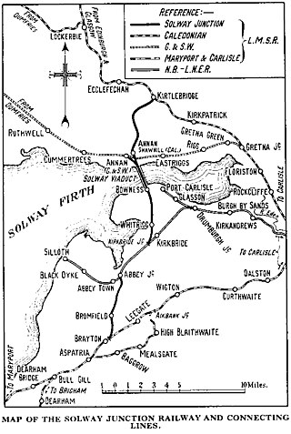
The Solway Junction Railway was built by an independent railway company to shorten the route from ironstone mines in Cumberland to ironworks in Lanarkshire and Ayrshire.
Abbey Junction railway station was the railway junction where the branch line to Silloth on the Solway Firth divided from the Solway Junction Railway in the English county of Cumberland.
The Hamilton and Strathaven Railway was a historic railway in Scotland. It ran from a junction with the Hamilton Branch of the Caledonian Railway to a terminus at Strathaven. The railway was worked from the start by the Caledonian Railway, who absorbed the railway company in 1864.

King Edward railway station was a railway station at King Edward, King Edward Parish, Aberdeenshire, Scotland on the rural branchline to Macduff. It was opened in 1860 to passengers by the Banff, Macduff and Turriff Junction Railway and was closed to regular passenger traffic in 1951. King Edward was 24 miles 42 chains (39.5 km) from the junction at Inveramsay and 247 feet (75 m) above sea level.

Annan Shawhill was a station on the Solway Junction Railway at Annan in Dumfries and Galloway, Scotland. The branch line ran between a junction with the Caledonian Railway Main Line at Kirtlebridge, across the Glasgow South Western Line, over the Solway Viaduct into Cumberland, England. The station opened for passenger services in 1870. Passenger services were withdrawn in the early 1930s when the cost of maintaining the Solway Viaduct was deemed too high to sustain. Although the line to England was removed, the Scottish part of the branch to Annan Shawhill remained opened for freight until it was finally closed in the 1950s.

Great Broughton railway station briefly served the village of Great Broughton, near Cockermouth in Cumberland, England.
Whitrigg was a railway station on the Bowness Moss which served Whitrigg, a hamlet in Cumbria on the English side of the Solway Firth. The station opened on 8 August 1870 by the Caledonian Railway on a line constructed from the Caledonian Railway Main Line at Kirtlebridge across the Glasgow South Western Line, then forming the Solway Junction Railway over the Solway Viaduct to Brayton. The line opened for freight on 13 September 1869.

Bromfield was a railway station which served Bromfield, a small settlement in Cumbria on the English side of the Solway Firth. The station opened in 1873 by the Caledonian Railway on a line constructed from the Caledonian Railway Main Line at Kirtlebridge across the Glasgow South Western Line, then forming the Solway Junction Railway over the Solway Viaduct to Brayton. The line opened for freight trains on 13 September 1869.

Brayton was a railway station which served as the interchange for the Solway Junction Railway (SJR) with the Maryport and Carlisle Railway (M&CR); it also served nearby Brayton Hall and district in Cumbria. The station was opened by the M&CR and became a junction station in 1870 on the 25 mile long SJR line.
Kirtlebridge railway station was a station which served the rural area around Kirtlebridge and Eaglesfield, north of Annan in Dumfriesshire, Scotland; the location is now within the area of Dumfries and Galloway unitary council.

Floriston railway station was a station which served the rural area around Floristonrigg, Rockcliffe Parish, south of Gretna in the English county of Cumberland. It was served by local trains on what is now known as the West Coast Main Line. The nearest station for Floriston is now at Carlisle.
Rockcliffe railway station, later Rockcliffe Halt was a station which served the rural area around Rockcliffe, Rockcliffe parish, north of Carlisle in the English county of Cumberland. It was served by local trains on what is now known as the West Coast Main Line. The nearest station for Rockcliffe is now at Carlisle. It lay some distance from the village.
Siddick Junction railway station was opened by the Cleator and Workington Junction (C&WJR) and London and North Western Railways in 1880 to provide exchange platforms for passengers wishing to change trains from one company's line to the other. A passenger travelling from Maryport to Distington, for example, would change at Siddick Junction. As a purely exchange station - like Dovey Junction and Dukeries Junction elsewhere in the country - the owning companies would not need to provide road or footpath access or ticketing facilities as no passengers were invited to enter or leave the station except by train.
Linefoot railway station, sometimes referred to as Linefoot Junction and sometimes as Linefoot Goods, briefly served the scattered community around the crossroads at Linefoot, near Cockermouth in Cumberland, England.
Camerton Colliery Halt railway station was an unadvertised halt for workers at one or both of the collieries at Camerton, near Cockermouth in Cumberland, England.
Buckhill Colliery Halt railway station was an unadvertised halt for workers at Buckhill Colliery north east of Camerton, near Cockermouth in Cumberland, England.

Cumberland and Westmorland Convalescent Institution railway station was a terminus off the short Blitterlees Branch off the Carlisle and Silloth Bay Railway, within Silloth itself. The larger railway ran from Carlisle, England. The station does not appear on standard railway maps, but it can be discerned with a magnifying glass on at least two published maps and clearest of all on the 1914 25" OS map.
Silloth Battery Extension railway station was the terminus of the Blitterlees Branch, which turned southwards off the Carlisle and Silloth Bay Railway's Silloth Branch a short distance east of Silloth station. The larger railway ran from Carlisle, England. The Bitterlees Branch does not appear on standard railway maps, but it is clear on OS maps, though the station is not identifiable as such.
Carlisle Canal railway station was opened in 1854 as the Carlisle terminus of the Port Carlisle Railway Company's line from Port Carlisle in Cumbria, England. That line was largely laid along the course of the Carlisle Canal, hence the station's name.
