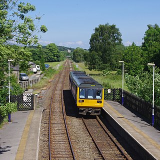
The Settle–Carlisle line is a 73-mile-long (117 km) main railway line in northern England. The route, which crosses the remote, scenic regions of the Yorkshire Dales and the North Pennines, runs between Settle Junction, on the Leeds–Morecambe line, and Carlisle, near the English-Scottish borders. The historic line was constructed in the 1870s and has several notable tunnels and viaducts such as the imposing Ribblehead.
The North Western Railway (NWR) was an early British railway company in the north-west of England. It was commonly known as the "Little" North Western Railway, to distinguish it from the larger London and North Western Railway (LNWR).

The Lancaster and Carlisle Railway was a main line railway opened between those cities in 1846. With its Scottish counterpart, the Caledonian Railway, the Company launched the first continuous railway connection between the English railway network and the emerging network in central Scotland. The selection of its route was controversial, and strong arguments were put forward in favour of alternatives, in some cases avoiding the steep gradients, or connecting more population centres. Generating financial support for such a long railway was a challenge, and induced the engineer Joseph Locke to make a last-minute change to the route: in the interests of economy and speed of construction, he eliminated a summit tunnel at the expense of steeper gradients.

Oxenholme Lake District railway station in Oxenholme, near Kendal, Cumbria, England, is on the West Coast Main Line and at the start of the Windermere branch line to Windermere. The station, which serves as a main line connection point for Kendal and Windermere, is managed by Avanti West Coast and owned by Network Rail.

Lancaster railway station is a railway station that serves the city of Lancaster in Lancashire, England. It is one of the principal stations on the West Coast Main Line. It is located 20 miles 78 chains (33.76 km) from Preston and is the zero point for mileages onward to Carlisle.

Clapham is a railway station on the Bentham Line, which runs between Leeds and Morecambe via Skipton. The station, situated 48 miles (77 km) north-west of Leeds, serves the village of Clapham in North Yorkshire. It is owned by Network Rail and managed by Northern Trains.

Docker is a civil parish in the South Lakeland district of the English county of Cumbria. Docker is 4.3 miles north east of the market town of Kendal. At the 2011 census Docker was grouped with Lambrigg giving a total population of 260.

Tebay railway station was situated on the Lancaster and Carlisle Railway (L&CR) between Lancaster and Penrith. It served the village of Tebay, Cumbria, England. The station opened in 1846, and closed on 1 July 1968.

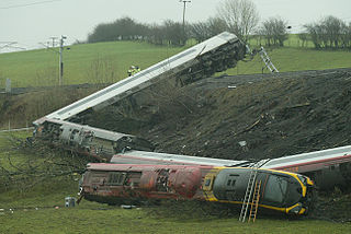
The Grayrigg derailment was a fatal railway accident that occurred at approximately 20:15 GMT on 23 February 2007, just to the south of Grayrigg, Cumbria, in the North West England region of the United Kingdom. The accident investigation concluded that the derailment was caused by a faulty set of points on the Down Main running line, controlled from Lambrigg ground frame. The scheduled inspection on 18 February 2007 had not taken place and the faults had gone undetected.

The Leeds–Morecambe line, also known as the Bentham line, is a railway line running between Leeds, Skipton, Lancaster and Morecambe in northern England. The service is operated by Northern. The route covered by the service was historically part of the Midland Railway. The line is electrified at 25 kV AC overhead between Leeds City and Skipton- this section is known as the Airedale line.

The Ingleton branch line was a rural railway line in the West Riding of Yorkshire, Lancashire and Westmorland in England. It was originally planned in 1846 to form part of a main line route from London to Scotland, but fell victim to rivalry between railway companies. Completion was delayed until 1861, and it was only ever a rural branch line, serving the village of Ingleton and towns of Kirkby Lonsdale and Sedbergh. It closed to passengers in 1954 and was dismantled in 1967.
Ingleton (Midland) railway station was one of two stations serving the village of Ingleton, North Yorkshire, England. It was originally open for just ten months between 1849 and 1850, and did not reopen until 1861. It then served as the frontier between the Midland Railway to the south and the London and North Western Railway to the North, with trains from each railway terminating at the station. Through trains did not begin until the two companies were merged in 1923. The station closed in 1954. The village's Community Centre is now on the site of the former station.
Ingleton (L&NW) railway station was one of two stations serving the village of Ingleton, North Yorkshire, England. It owed its existence to the intense rivalry between the two stations' owners. It opened, along with the Ingleton Branch Line, in 1861, and closed in 1917, by which time the two railway companies had become more cooperative.

Crosby Garrett was a railway station which served the village of Crosby Garrett in Cumbria, England. It was situated on the Settle-Carlisle Line 38+1⁄4 miles (61.6 km) south of Carlisle. The station was built by the Midland Railway and opened in 1876. It was closed by the British Transport Commission as an economy measure in 1952.
Calthwaite railway station in Hesket parish, was situated on the Lancaster and Carlisle Railway between Carlisle and Penrith. It served the village of Calthwaite, Cumbria, England. The station opened in 1847, and closed on 7 April 1952.
Plumpton railway station in Hesket parish in what is now Cumbria but was then Cumberland in the north west of England, was situated on the Lancaster and Carlisle Railway between Carlisle and Penrith. It served the village of Plumpton and the surrounding hamlets. The station opened on 17 December 1846, and closed on 31 May 1948.

Sedbergh railway station was in the West Riding of Yorkshire, England, on the Ingleton Branch Line, about half a mile (1 km) west of Sedbergh, open to passengers from 1861 to 1954. Both the town and the station site now lie in Cumbria following boundary changes in 1974.

Barbon railway station was located in Westmorland, England, serving the town and locale of Barbon on the Ingleton Branch Line.

Kirkby Lonsdale railway station was located in Lancashire, England, on the Ingleton Branch Line, 2 miles (3 km) from the town of Kirkby Lonsdale in Westmorland.
Middleton-on-Lune railway station was located in Westmorland, England,, serving the hamlet and rural locale of Middleton on the Ingleton Branch Line. It was opened as Middleton in 1861 and renamed Middleton-on-Lune on 19 July 1926, closing in 1931.


