
Chiricahua is a band of Apache Native Americans.

Catron County is a county in the U.S. state of New Mexico. As of the 2020 census, the population was 3,579, making it New Mexico's third-least populous county. Its county seat is Reserve. Catron County is New Mexico's largest county by area.

Silver City is a town in Grant County, New Mexico, United States. It is the county seat and the home of Western New Mexico University. As of the 2010 census the population was 10,315. As of the 2020 census, the population was 9,704.
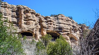
Gila Cliff Dwellings National Monument is a U.S. National Monument created to protect Mogollon cliff dwellings in the Gila Wilderness on the headwaters of the Gila River in southwest New Mexico. The 533-acre (2.16 km2) national monument was established by President Theodore Roosevelt through executive proclamation on November 16, 1907. It is located in the extreme southern portion of Catron County. Visitors can access the monument by traveling northbound from Silver City, New Mexico, 45 miles (72 km) on NM 15.

Victorio was a warrior and chief of the Warm Springs band of the Tchihendeh division of the central Apaches in what is now the American states of Texas, New Mexico, Arizona, and the Mexican states of Sonora and Chihuahua.

The Apache Wars were a series of armed conflicts between the United States Army and various Apache tribal confederations fought in the southwest between 1849 and 1886, though minor hostilities continued until as late as 1924. After the Mexican–American War in 1846, the United States annexed conflicted territory from Mexico which was the home of both settlers and Apache tribes. Conflicts continued as American settlers came into traditional Apache lands to raise livestock and crops and to mine minerals.

The Mogollon Mountains or Mogollon Range are a mountain range in Grant County and Catron County of southwestern New Mexico, in the Southwestern United States. They are primarily protected within the Gila National Forest.
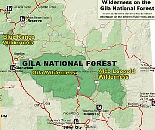
Gila Wilderness was designated the world's first wilderness area on June 3, 1924. Along with Aldo Leopold Wilderness and Blue Range Wilderness, the 558,014 acre wilderness is part of New Mexico's Gila National Forest. The wilderness is approximately 27 miles (43 km) from north to south and 39 miles (63 km) east to west.
James, Jim or Jimmy Cooney may refer to:

Mogollon, also called the Mogollon Historic District, is a former mining town located in the Mogollon Mountains in Catron County, New Mexico, United States. Located east of Glenwood and Alma, it was founded in the 1880s at the bottom of Silver Creek Canyon to support the gold and silver mines in the surrounding mountains. The "Little Fannie" mine became the most important employer for the town. During the 1890s, Mogollon had a transient population of between 3,000 and 6,000 miners. Because of its isolation, it had a reputation as one of the wildest mining towns in the West. Today Mogollon is listed as Fannie Hill Mill and Company Town Historic District on the National Register of Historic Places.
Alma is an unincorporated community and census-designated place in Catron County, New Mexico, United States, north of Glenwood and south of Reserve.

Glenwood is a census-designated place in Catron County, New Mexico, United States. As of the 2010 census it had a population of 143. The area was founded in 1878 as Bush Ranch. Located near the San Francisco River, Glenwood is 61 miles (98 km) northwest of Silver City on U.S. Route 180, and is 38 miles (61 km) south of Reserve.
James C. Cooney was a sergeant of the U.S. Army in the 8th U.S. Cavalry when he found large silver and gold reserves in the Mogollon Mountains of Catron County, New Mexico. He was transferred to Fort Bayard, near Silver City, New Mexico in 1870. While scouting for the 8th U.S. Cavalry north of Mogollon and east of Alma, he discovered silver ore in the Mogollon Mountains. He began working the claim after leaving the Army in 1876.
The Alma Massacre involved an April 28, 1880, Chiricahua Apache raid on United States settlers' homes around Alma, New Mexico Territory. At least 41 people were killed during the raid.
Apache Creek is a census-designated place in Catron County, New Mexico, United States. As of the 2010 census it had a population of 67. Located 3 miles (5 km) northeast of Cruzville, it is situated at the confluence of Apache Creek and the Tularosa River. The Apache Creek Pueblo, also called the "Apache Creek Ruin", is near the town. It was listed by the New Mexico Historic Preservation Commission in 1969.
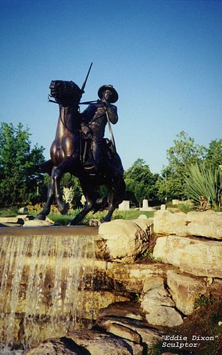
The Battle of Fort Tularosa occurred in May 1880 near the present-day town of Aragon in Catron County, New Mexico. In an ongoing campaign to keep from being forced to live on reservations, Chiricahua Apache warriors led by Victorio attacked Fort Tularosa north of San Francisco Plaza. Buffalo Soldiers from the United States Army's 9th Cavalry, led by Sergeant George Jordan, repulsed the attack.
The Bearwallow Mountain Lookout Cabins and Shed are located in the Bearwallow Park near Mogollon, New Mexico. Built in 1940 by the Works Progress Administration, they are one of three New Deal-era buildings in the Gila National Forest, which also include the El Caso Lookout Complex and the Mangas Mountain Lookout Complex. In 2006 the buildings were threatened by the Bear Fire, which burned across Bearwallow Mountain.
Cooney's Tomb is a historic location near Alma, Catron County, New Mexico. Marked by a large boulder on the side of a roadway, it is the site where former Army Sergeant James C. Cooney was interred in 1880 after being killed by a group of Apaches.
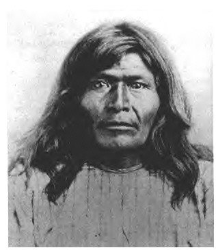
Victorio's War, or the Victorio Campaign, was an armed conflict between the Apache followers of Chief Victorio, the United States, and Mexico beginning in September 1879. Faced with arrest and forcible relocation from his homeland in New Mexico to San Carlos Indian Reservation in southeastern Arizona, Victorio led a guerrilla war across southern New Mexico, west Texas and northern Mexico. Victorio fought many battles and skirmishes with the United States Army and raided several settlements until the Mexican Army killed him and most of his warriors in October 1880 in the Battle of Tres Castillos. After Victorio's death, his lieutenant Nana led a raid in 1881.
State Road 159 (NM 159) is a 30.551-mile (49.167 km) state road located entirely within Catron County, New Mexico, United States. NM 159's western terminus is at U.S. Route 180 (US 180) south of Alma. It heads east via Mogollon to a few miles past Willow Creek Campground in Gila National Forest where it continues as Catron County Route 28 (CR 28), which is also known as Bursum Road.


