Mogollon, New Mexico

Last updated

Mogollon, New Mexico
Old car, pump, Mogollon NM.jpg
Street scene in the Mogollon Historic District
USA New Mexico location map.svg
Red pog.svg
Mogollon
Location within the state of New Mexico
Usa edcp location map.svg
Red pog.svg
Mogollon
Mogollon (the United States)
Coordinates: 33°23′48″N108°47′39″W / 33.39667°N 108.79417°W / 33.39667; -108.79417
Country United States
State New Mexico
County Catron
Population
 (2000)
  Total0
Time zone UTC-5 (Mountain (MST))
  Summer (DST)MDT
Area code 575
Mogollon Historic District
Cinco de Mayo, Mogollon, N.M, 1914.jpg
Cinco de Mayo celebration in Mogollon, 1914
USA New Mexico location map.svg
Red pog.svg
Usa edcp location map.svg
Red pog.svg
Location NM 78/Bursum Rd., Mogollon, New Mexico
Area33 acres (13 ha)
Built1889 (1889)
NRHP reference No. 87001541 [1]
NMSRCP No. 38
Significant dates
Added to NRHPSeptember 10, 1987
Designated NMSRCPFebruary 21, 1969

Mogollon, also called the Mogollon Historic District, is a former mining town located in the Mogollon Mountains in Catron County, New Mexico, United States. Located east of Glenwood and Alma, it was founded in the 1880s at the bottom of Silver Creek Canyon to support the gold and silver mines in the surrounding mountains. The "Little Fannie" mine became the most important employer for the town. During the 1890s, Mogollon had a transient population of between 3,000 and 6,000 miners. Because of its isolation, it had a reputation as one of the wildest mining towns in the West. [2] [3] Today Mogollon is listed as Fannie Hill Mill and Company Town Historic District on the National Register of Historic Places. [4]

Contents

History

Old mine cars, Mogollon Old mine cars, Mogollon NM.jpg
Old mine cars, Mogollon

In the 1870s, Sergeant James C. Cooney of Fort Bayard found a rich strand of gold in the Gila Mountains near the future site of Mogollon. [5] A miner named John Eberle built the first cabin in Mogollon in 1889, after mines were developed in Silver Creek, which runs through the town. A jail and post office opened in 1890, and the first school was added in 1892. [6] During this period of growth, Mogollon absorbed the population of nearby Cooney, and helped towns like Glenwood, Gila and Cliff grow because of their locations along the trail to the town. Between 1872 and 1873 the stagecoach from Mogollon to Silver City was robbed 23 times by the same assailant. He was eventually apprehended by agents of the Wells Fargo. [7]

In 1909, the population of Mogollon was about 2,000. That same year the town had five saloons, two restaurants, four merchandise stores, two hotels and several brothels located in two red light districts. The town also had a photographer, the Midway Theatre, an ice maker, and a bakery. The Silver City and Mogollon Stage Line provided daily service, hauling passengers, freight, gold, and silver bullion 80 miles between the two towns in almost 15 hours. [6]

By 1915, payroll in Mogollon was $75,000 monthly. [8] The community expanded to a population of 1,500 that year, with electricity, water, and telephone facilities. The school offered education to about 300 students. [6]

From early in its life, Mogollon was plagued by a series of fires and floods. The first big fire of 1894 wiped out most of the town buildings, which were made of wood. Fires followed in 1904, 1910, 1915, and 1942. Citizens usually immediately rebuilt, each time using more stone and adobe. Floods rushed through Silver Creek in 1894, 1896, 1899, and 1914. They washed away mine tailings, dumps, bridges, houses, and people. [6]

Over 20 mines were built in the Mogollon area. [9] By 1914 the mining district produced approximately $1.5 million of gold and silver, about 40% of New Mexico's precious metals for that year. In their lifetime, over 18 million ounces of silver were taken from the mines of the Mogollon Mountains, which was one-quarter of New Mexico's total production. Close to $20 million in gold, silver and copper were extracted, with silver accounting for about two-thirds of the total. Many regarded Silver City as merely a railhead for Mogollon's eight-team freight wagons packed with gold and silver ore. [10]

As the ore grade decreased, so did profits, and by 1930 the population in had dropped to a reported 200. By 1940 mining activity had drastically decreased. The Fanny Mill was the only local mill to process the ore in Mogollon, so the closure of the Fanny mines in 1942 also meant the closure of the others, who previously took their ore to Fannie. A brief and minor resurgence occurred during World War II, as stagnant mines across the country began to produce needed minerals and precious metals to fuel the wartime manufacturing boom. Mining production has ceased since then. [11]

In 1973, a Spaghetti Western called My Name is Nobody , starring Henry Fonda and Terence Hill, was filmed in Mogollon. [12] A saloon and general store in town were built as part of the movie set.

With refining technology advancement, some attempts have been made to resume operations. In the 1980s, Challenge Mining Company was testing ore concentrations but the project never took off. [13] By 2023 Canadian mineral exploration company Summa Silver acquired 7,730 acres of claims to the mining district in Mogollon. [14] Testing has found high-grade ore, and Summa has ambitions to begin mining pending future results. [15] [16]

Today the town has several private homes and a few small businesses, including the Silver Creek Inn, which operates in a former boarding lodge called the Mogollon House built by Frank Lauderbaugh in 1885. [17] The establishment is reportedly filled with ghosts from the mining era. [18]

Mogollon historic district

Recent photo of J.P. Holland General Store JP Holland General Store by Cam Vilay.jpg
Recent photo of J.P. Holland General Store

The entire Mogollon community was added to the National Register of Historic Places as Fannie Hill Mill and Company Town Historic District in 1987. It was cited for its industrial and architectural legacy from 1875 through 1949. [4]

Education

It is in the Reserve Independent School District. [19]

See also

Related Research Articles

<span class="mw-page-title-main">Catron County, New Mexico</span> County in New Mexico, United States

Catron County is a county in the U.S. state of New Mexico. As of the 2020 census, the population was 3,579, making it New Mexico's third-least populous county. Its county seat is Reserve. Catron County is New Mexico's largest county by area.

<span class="mw-page-title-main">Hillsboro, New Mexico</span> Unincorporated community & CDP in New Mexico, United States

Hillsboro is an unincorporated community in Sierra County, New Mexico, United States, located in the southwestern part of the state. It was founded in 1877, following the discovery of gold. The community was the county seat of Sierra County from 1884 until 1936, when Hot Springs became the county seat.

<span class="mw-page-title-main">Kennecott, Alaska</span> United States historic place

Kennecott, also known as Kennicott and Kennecott Mines, is an abandoned mining camp in the Copper River Census Area in the U.S. state of Alaska that was the center of activity for several copper mines. It is located beside the Kennicott Glacier, northeast of Valdez, inside Wrangell-St. Elias National Park and Preserve. The camp and mines are now a National Historic Landmark District administered by the National Park Service.

<span class="mw-page-title-main">Colorado Silver Boom</span> Period of silver mining activity in Colorado, U.S.

The Colorado Silver Boom was a dramatic expansionist period of silver mining activity in the U.S. state of Colorado in the late 19th century. The boom started in 1879 with the discovery of silver at Leadville. Over 82 million dollars worth of silver was mined during the period, making it the second great mineral boom in the state, and coming 20 years after the earlier and shorter Colorado Gold Rush of 1859. The boom was largely the consequence of large-scale purchases of silver by the United States Government authorized by Congress in 1878. The boom endured throughout the 1880s, resulting in an intense increase in both the population and wealth of Colorado, especially in the mountains. It came to an end in 1893 in the wake of the collapse of silver prices caused by the repeal of Sherman Silver Purchase Act.

<span class="mw-page-title-main">Mercur, Utah</span> Ghost town in Utah, United States

Mercur is a historical hard rock mining ghost town in Tooele County, Utah, United States. In 1891, it became the site of the first successful use of the cyanide process of gold extraction in the United States, the dominant metallurgy today. Its elevation above sea level is approximately 2,042 m. The nearby Mercur Gold Mine was re-opened by Barrick Gold in 1985, with mining operations again coming to an end in 1997. The reclamation and restoration project was set to continue up to 2010.

<span class="mw-page-title-main">Glenwood, New Mexico</span> Census-designated place in New Mexico, United States

Glenwood is a census-designated place in Catron County, New Mexico, United States. As of the 2010 census it had a population of 143. The area was founded in 1878 as Bush Ranch. Located near the San Francisco River, Glenwood is 61 miles (98 km) northwest of Silver City on U.S. Route 180, and is 38 miles (61 km) south of Reserve.

James C. Cooney was a sergeant of the U.S. Army in the 8th U.S. Cavalry when he found large silver and gold reserves in the Mogollon Mountains of Catron County, New Mexico. He was transferred to Fort Bayard, near Silver City, New Mexico in 1870. While scouting for the 8th U.S. Cavalry north of Mogollon and east of Alma, he discovered silver ore in the Mogollon Mountains. He began working the claim after leaving the Army in 1876.

<span class="mw-page-title-main">Silver mining in the United States</span>

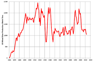
Silver mining in the United States began on a major scale with the discovery of the Comstock Lode in Nevada in 1858. The industry suffered greatly from the demonetization of silver in 1873 by the Coinage Act of 1873, known pejoratively as the "Crime of 73", but silver mining continues today.

Apache Creek is a census-designated place in Catron County, New Mexico, United States. As of the 2010 census it had a population of 67. Located 3 miles (5 km) northeast of Cruzville, it is situated at the confluence of Apache Creek and the Tularosa River. The Apache Creek Pueblo, also called the "Apache Creek Ruin", is near the town. It was listed by the New Mexico Historic Preservation Commission in 1969.

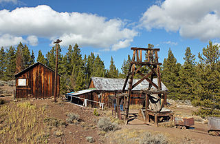
Cooney is a ghost town in Catron County, New Mexico, United States, east of Alma. Cooney was once home to gold and silver prospectors in the nearby Mogollon Mountains.

Orogrande is an unincorporated community in Otero County, New Mexico, United States, located at a latitude of 32.37111 and a longitude of -106.08389 in the Jarilla Mountains of the Tularosa Basin on U.S. 54 between El Paso, Texas and Alamogordo. Originally a mining town named Jarilla Junction due to its proximity to the Jarilla Mountains, established in 1905, the town was renamed Orogrande in 1906 and is not far from similar mining towns named Brice and Ohaysi. The population soared to approximately 2000 as the result of a gold rush that occurred in 1905, but quickly collapsed almost to the point of depopulation when the gold deposits proved much less abundant than expected. There are still numerous abandoned mines in the area which fall under the jurisdiction of the Bureau of Land Management. Other land around Orogrande is part of a military reservation under the control of Fort Bliss.

<span class="mw-page-title-main">Shafter, Texas</span> Ghost town in Texas, United States

Shafter is a ghost town in Presidio County, Texas, United States. The Texas Attorney General's Office listed a population of 11 as of the 2000 Census. It was named in honor of General William R. Shafter, who at one point commanded the nearby Fort Davis. As of 2012, at least one silver mine, La Mina Grande, had been reopened by Aurcana Corporation.

<span class="mw-page-title-main">Mary Murphy Mine</span>

The Mary Murphy Mine was the principal gold mine of the Chalk Creek mining district of Chaffee County, Colorado, United States, near St. Elmo, Colorado. The Mary Murphy Mine operated continuously from 1870 to 1925, and produced 220 thousand ounces of gold, worth $4.4 million then, plus considerable silver, lead, and zinc. There were two aerial tramways connecting the mine to Romley, Colorado, and the Denver, South Park and Pacific Railroad.

<span class="mw-page-title-main">Silver City, Utah</span> Ghost town in Utah, United States

Silver City is a ghost town located at the mouth of Dragon Canyon on the west flank of the East Tintic Mountains in northeast Juab County in central Utah, United States. It was a silver mining town approximately 90 miles (140 km) south-southwest of Salt Lake City. This area was considered part of the Tintic Mining District and also produced bismuth, copper, gold, and lead. Settlement began with the first mining strikes here in 1869. Silver City was inhabited until 1930, after the mines played out. Jesse Knight, known as the "Mormon Wizard" for his ability to find ore easily, decided to build a smelter in Silver City because it had the flattest ground in all of the Tintic Mining District. Silver City had several mines in 1890, but the mines hit water and were abandoned. Now there is little left other than a few holes where mines were, and a number of tailings piles. The Silver City Cemetery, however, survives and is listed on the National Register of Historic Places.

<span class="mw-page-title-main">Bristol Wells Town Site</span> United States historic place

Bristol Wells, also known as National City, Bristol City and Tempest, is a ghost town in Lincoln County, Nevada. The mining town was located on the west side of Bristol Mountain, 14 miles (23 km) northwest of Pioche, Nevada.

<span class="mw-page-title-main">Harshaw, Arizona</span> Ghost town in Arizona, United States

Harshaw is a ghost town in Santa Cruz County in the southeastern part of the U.S. state of Arizona. The town was settled in the 1870s, in what was then Arizona Territory. Founded as a mining community, Harshaw is named after the cattleman-turned-prospector David Tecumseh Harshaw, who first successfully located silver in the area. At the town's peak near the end of the 19th century, Harshaw's mines were among Arizona's highest producers of ore, with the largest mine, the Hermosa, yielding approximately $365,455 in bullion over a four-month period in 1880.

McMillenville, also known as McMillianville or McMillanville, is a populated place in Gila County, Arizona. Silver ore was discovered by chance in 1876 by Theodore H. Harris and Charles McMillen, and the town formed around the ore deposits.

Cooney's Tomb is a historic location near Alma, Catron County, New Mexico. Marked by a large boulder on the side of a roadway, it is the site where former Army Sergeant James C. Cooney was interred in 1880 after being killed by a group of Apaches.

Maitland, originally called Garden City and sometimes misspelled Midland, is a ghost town in Lawrence County, South Dakota, United States. It was a mining community that boomed during the Black Hills Gold Rush, but was abandoned by about 1915.

References

  1. "National Register Information System". National Register of Historic Places . National Park Service. July 9, 2010.
  2. Till, T. and Jordan, T. (2001) Great Ghost Towns of the West. Portland, OR: Graphic Arts Center Publishing. p. 72.
  3. Hardin, J. (2006) Old Guns and Whispering Ghosts. Boise, ID: Shoot Magazine Corporation. p. 43.
  4. 1 2 (nd) National Register of Historic Places - Catron County, New Mexico. Retrieved 6/13/07.
  5. (nd) Mogollon, New Mexico Archived 2007-09-29 at the Wayback Machine . Retrieved 6/11/07.
  6. 1 2 3 4 (nd) Mogollon - Getting there. Retrieved 6/13/07.
  7. Hardin, J. (2006) p. 96.
  8. (nd) Mogollon, New Mexico mining camps Archived 2007-09-28 at the Wayback Machine . New Mexico Wanderings. Retrieved 6/12/07.
  9. https://www.mindat.org/loc-21687.html
  10. (2004) Ghost Town Mogollon 'Reopens' for Summer Archived 2007-09-27 at the Wayback Machine . New Mexico Department of Tourism. Retrieved 6/13/07.
  11. https://geoinfo.nmt.edu/publications/periodicals/nmg/1/n1/nmg_v1_n1_p7.pdf
  12. (nd) Mogollon, New Mexico. Retrieved 6/11/07.
  13. https://geoinfo.nmt.edu/publications/periodicals/nmg/1/n1/nmg_v1_n1_p7.pdf
  14. https://wildearthguardians.org/press-releases/canadian-mining-company-stakes-more-claims-on-the-edge-of-americas-first-wilderness/
  15. https://summasilvernm.com/summa-silver-faq/
  16. https://summasilver.com/mogollon-project/
  17. (nd) Silver Creek Inn Archived 2007-07-02 at the Wayback Machine website. Retrieved 6/13/07.
  18. (2001) "Mogollon: Remote Ghost Town, A Haunted Bed-And-Breakfast, and Some Seriously Tasty Pie". Men's Journal. November.
  19. "2020 CENSUS - SCHOOL DISTRICT REFERENCE MAP: Catron County, NM" (PDF). U.S. Census Bureau . Retrieved July 12, 2022.