
Catron County is a county in the U.S. state of New Mexico. As of the 2020 census, the population was 3,579, making it New Mexico's third-least populous county. Its county seat is Reserve. Catron County is New Mexico's largest county by area.
Reserve is a village in Catron County, New Mexico, United States. The population was 289 as of the 2010 census, down from 387 in 2000. It is the county seat of Catron County. Currently the village has two grocery stores, a hardware store, a bar, fairgrounds, and a health clinic. It is the site where Elfego Baca held off a gang of Texan cowboys who wanted to kill him for arresting cowboy Charles McCarty.

Las Vegas is a city in and the county seat of San Miguel County, New Mexico, United States. Once two separate municipalities, both were named Las Vegas—West Las Vegas and East Las Vegas ; they are separated by the Gallinas River and retain distinct characters and separate, rival school districts.

Aragon is a census-designated place on the Tularosa River in Catron County, New Mexico, United States. As of the 2010 census it had a population of 94. It is located at an altitude of 7,135 feet (2,175 m), 7 miles (11 km) northeast of Apache Creek.

Datil is a census-designated place in Catron County, New Mexico, United States. As of the 2010 census it had a population of 54. Located at the intersection of U.S. Route 60 and New Mexico State Road 12, Datil is on the edge of the Cibola National Forest. The Very Large Array is also nearby. Rock climbers are attracted to Datil because it holds the Enchanted Tower, a climbing hotspot.

The Old Spanish Trail is a historical trade route that connected the northern New Mexico settlements of Santa Fe, New Mexico with those of Los Angeles, California and southern California. Approximately 700 mi (1,100 km) long, the trail ran through areas of high mountains, arid deserts, and deep canyons. It is considered one of the most arduous of all trade routes ever established in the United States. Explored, in part, by Spanish explorers as early as the late 16th century, the trail was extensively used by traders with pack trains from about 1830 until the mid-1850s.

The Plains of San Agustin is a region in the southwestern U.S. state of New Mexico in the San Agustin Basin, south of U.S. Highway 60. The area spans Catron and Socorro Counties, about 50 miles (80 km) west of the town of Socorro and about 25 miles north of Reserve. The plains extend roughly northeast-southwest, with a length of about 55 miles (88 km) and a width varying between 5–15 miles (8–24 km). The basin is bounded on the south by the Luera Mountains and Pelona Mountain ; on the west by the Tularosa Mountains; on the north by the Mangas, Crosby, Datil, and Gallinas Mountains; and on the east by the San Mateo Mountains. The Continental Divide lies close to much of the southern and western boundaries of the plains.

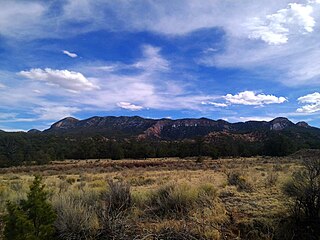
The Mogollon Mountains or Mogollon Range are a mountain range in Grant County and Catron County of southwestern New Mexico, in the Southwestern United States. They are primarily protected within the Gila National Forest.
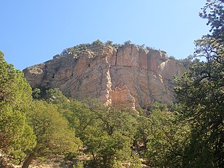
Whitewater Baldy is the highest point of the Mogollon Mountains and the 3rd highest mountain in Southern New Mexico, after Sierra Blanca Peak and Lincoln County's Lookout Mountain. It is located in Catron County in the Gila Wilderness, part of the Gila National Forest. It lies about 15 miles (24 km) east of the town of Glenwood.
Apache Creek is a census-designated place in Catron County, New Mexico, United States. As of the 2010 census it had a population of 67. Located 3 miles (5 km) northeast of Cruzville, it is situated at the confluence of Apache Creek and the Tularosa River. The Apache Creek Pueblo, also called the "Apache Creek Ruin", is near the town. It was listed by the New Mexico Historic Preservation Commission in 1969.
Cruzville is a census-designated place in Catron County, New Mexico, United States, 9 miles (14 km) northeast of Reserve. It is located in the Apache National Forest. As of the 2010 census it had a population of 72.

U.S. Route 60 (US 60) is an east–west United States Highway within New Mexico. It begins at the Arizona state line and continues east to the Texas state line.
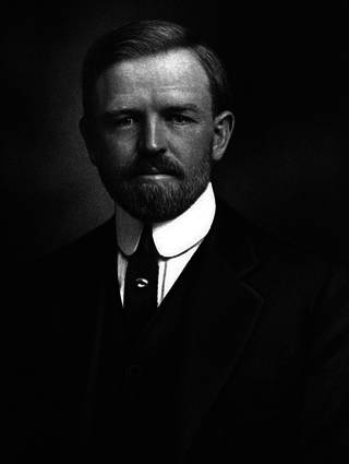
William Raymond Morley Jr. was an American college football player, coach, and rancher. Born in New Mexico, he played football at the University of Michigan and Columbia University and was selected as an All-American in 1900 and 1901. Morley served as the head coach of the Columbia Blue and White football team from 1902 to 1905. He later returned to New Mexico where he was a successful cattle and sheep rancher. He was posthumously inducted into the College Football Hall of Fame as a player in 1971.
The Datil-Mogollon Section is a physiographic section of the larger Colorado Plateau province, which in turn is part of the larger Intermontane Plateaus physiographic division. It is a transitional area between the Basin and Range Province and the Colorado Plateau Province. It is also a newly defined unit that includes the southern part of the area previously designated the Datil Section.
The Mogollon-Datil volcanic field is a large silicic volcanic field in western New Mexico. It is a part of an extensive Eocene to Oligocene volcanic event which includes the San Juan volcanic field in southwestern Colorado, the Trans-Pecos volcanic field in west Texas and north central Mexico, the Boot Heel volcanic field in the bootheel of southwestern New Mexico and adjacent areas of Arizona and Mexico; and the vast volcanic field of the Sierra Madre Occidental of western Mexico. The Mogollon-Datil volcanic field was formed in "four discrete pulses representing synchronized activity of two separate cauldron complexes".
New Mexico State Road 52 (NM 52) is an approximately 88.6 mi (142.6 km) long state highway in Socorro County in the state of New Mexico. It runs approximately north–south. Its northern terminus is near the Very Large Array at U.S. Route 60 (US 60) between the towns of Magdalena to the east and Datil to the west. For much of its length, it is running west of the two southern sections of the Magdalena District of Cibola National Forest, as well as running east of Gila National Forest. For approximately 30 miles or so nearest to its southern terminus, it runs east from Winston, NM. Its southern terminus is in Truth or Consequences at NM 181. For the two miles nearest to the southern terminus, the road is also designated NM 181. It is a paved 2 lane road north to the NM 59 junction and is graded dirt road for approximately 40–45 miles from near the junction of NM 59 to the VLA.
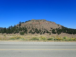
The Datil Mountains are a small range on the northern edge of the Mogollon-Datil volcanic field, just northwest of the Plains of San Agustin in the U.S. state of New Mexico. The range lies in Socorro and Catron Counties, north of the town of Datil, New Mexico and takes its name from the Spanish word for “date,” dating back over two hundred years. In The Place Names of New Mexico, Robert Julyan suggests two possible explanations for the name: 1) that “the seedpods of the broad-leafed yucca sufficiently resembled dates” or 2) “the Spanish applied the name to the fruit of the prickly pear cactus.” The area includes the major ridgeline of Madre Mountain, which is sacred ground to the Acoma, Laguna, and Zuni tribes, as well as several other unnamed peaks and ridges.
State Road 166 (NM 166) is a 1.9-mile-long (3.1 km) state highway in Socorro County, New Mexico, United States. NM 166's western terminus is at the end of route east-southeast of Datil, and the eastern terminus is at NM 52 east-southeast of Datil. It runs along a portion of a former alignment of U.S. Route 60 and serves the visitor center of the Very Large Array astronomical observatory.
The Spears Group is a group of geologic formations exposed in and around the northeast Mogollon-Datil volcanic field of southwestern New Mexico. It has a radiometric age of 33 to 39 million years, corresponding to the Eocene to Oligocene epochs.
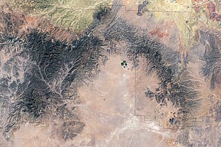
Lake San Agustín is a former lake in New Mexico, which developed as a pluvial lake in the Plains of San Agustín during Pleistocene glacial periods. During its highstands it covered an area of 1,200 square kilometres (460 sq mi) with a maximum depth of 70 metres (230 ft), and split into several separate lakes while drying out. The lake last appeared during the last glacial maximum (LGM) and dried out at the beginning of the Holocene, with the last remnant disappearing about 5,000 years ago.


