
Catron County is a county in the U.S. state of New Mexico. As of the 2020 census, the population was 3,579, making it New Mexico's third-least populous county. Its county seat is Reserve. Catron County is New Mexico's largest county by area.
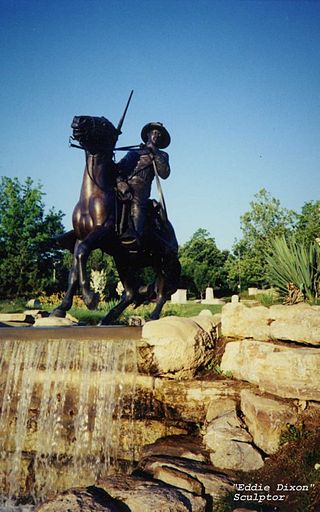
Reserve is a village in Catron County, New Mexico, United States. The population was 289 as of the 2010 census, down from 387 in 2000. It is the county seat of Catron County. Currently the village has two grocery stores, a hardware store, a bar, fairgrounds, and a health clinic. It is the site where Elfego Baca held off a gang of Texan cowboys who wanted to kill him for arresting cowboy Charles McCarty.

Socorro is a city in Socorro County in the U.S. state of New Mexico. It is in the Rio Grande Valley at an elevation of 4,579 feet (1,396 m). In 2010 the population was 9,051. It is the county seat of Socorro County. Socorro is located 74 miles (119 km) south of Albuquerque and 146 miles (235 km) north of Las Cruces.

Aragon is a census-designated place on the Tularosa River in Catron County, New Mexico, United States. As of the 2010 census it had a population of 94. It is located 7 miles (11 km) northeast of Apache Creek.

Santa Rosalía de Camargo, originally called Santa Rosalía, and now known as "Ciudad Camargo", is a city in the eastern part of the Mexican state of Chihuahua, located at the confluence of the Rio Parral and the Rio Conchos in the Allende Valley. It serves as the municipal seat of Camargo municipality and also serves as an important agricultural and livestock center for the area. Ciudad Camargo was originally founded in 1740 and refounded in 1792.
Mora or Santa Gertrudis de lo de Mora is a census-designated place in, and the county seat of, Mora County, New Mexico. It is located about halfway between Las Vegas and Taos on Highway 518, at an altitude of 7,180 feet. The Republic of Texas performed a semi-official raid on Mora in 1843. Two short battles of the Mexican–American War were fought in Mora in 1847, where U.S. troops eventually defeated the Hispano and Puebloan militia, effectively ending the Taos Revolt in the Mora Valley. The latter battle destroyed most of the community, necessitating its re-establishment.

Elfego Baca was a gunfighter, law enforcement officer, lawyer, and politician in New Mexico, who became an American folk hero of the later years of the New Mexico Territory frontier. His goal in life was to be a peace officer, and for "the outlaws to hear [his] steps a block away". He is known for his involvement in an 1884 shootout in Frisco, New Mexico, as well as later fictionalized representations of his life in Westerns released during the mid-20th century.

The Frisco shootout was an Old West gunfight that began on December 1, 1884, involving lawman Elfego Baca. The shootout happened in Reserve, New Mexico, and stemmed from Baca's arrest of a cowboy, Charlie McCarty, who had been shooting into the air and into buildings at random while intoxicated.
Luna is a census-designated place in northwestern Catron County, New Mexico, United States. As of the 2010 census it had a population of 158. It is situated on the San Francisco River and U.S. Route 180, 7 miles (11 km) east of the Arizona border and 20 miles (32 km) northwest of Reserve, the Catron county seat.

Glenwood is a census-designated place in Catron County, New Mexico, United States. As of the 2010 census it had a population of 143. The area was founded in 1878 as Bush Ranch. Located near the San Francisco River, Glenwood is 61 miles (98 km) northwest of Silver City on U.S. Route 180, and is 38 miles (61 km) south of Reserve.
James C. Cooney was a sergeant of the U.S. Army in the 8th U.S. Cavalry when he found large silver and gold reserves in the Mogollon Mountains of Catron County, New Mexico. He was transferred to Fort Bayard, near Silver City, New Mexico in 1870. While scouting for the 8th U.S. Cavalry north of Mogollon and east of Alma, he discovered silver ore in the Mogollon Mountains. He began working the claim after leaving the Army in 1876.
Apache Creek is a census-designated place in Catron County, New Mexico, United States. As of the 2010 census it had a population of 67. Located 3 miles (5 km) northeast of Cruzville, it is situated at the confluence of Apache Creek and the Tularosa River. The Apache Creek Pueblo, also called the "Apache Creek Ruin", is near the town. It was listed by the New Mexico Historic Preservation Commission in 1969.
Pleasanton is a census-designated place in the Williams Valley of Catron County, south of Glenwood and north of Cliff, in the U.S. state of New Mexico. As of the 2010 census it had a population of 106. It was renowned as a safehaven for Mormon polygamists for several years.
The Battle of Fort Tularosa occurred in May 1880 near the present-day town of Aragon in Catron County, New Mexico. In an ongoing campaign to keep from being forced to live on reservations, Chiricahua Apache warriors led by Victorio attacked Fort Tularosa north of San Francisco Plaza. Buffalo Soldiers from the United States Army's 9th Cavalry, led by Sergeant George Jordan, repulsed the attack.
The Reserve Independent School District is a school district headquartered in Reserve, New Mexico.

Concho is an unincorporated community and census-designated place (CDP) in Apache County, Arizona, United States. Concho is located on Arizona State Route 61, 14 miles (23 km) west of St. Johns. Concho was the original site for the state capital, due to its prosperous farming. As of the 2010 census, the Concho CDP had a population of 38.
Bartolomé Baca was Governor of the territory of Santa Fe de Nuevo México from August 1823 until September 1825. His very large landholdings were later the subject of disputes that eventually went to the Supreme Court of the United States.
Lower Frisco is a census-designated place in Catron County, New Mexico, United States. Its population was 31 as of the 2010 census. The community is part of San Francisco Plaza.
Middle Frisco is a census-designated place in Catron County, New Mexico, United States. Its population was 77 as of the 2010 census. The community is part of San Francisco Plaza.


