
The Borough of Stafford is a local government district with borough status in Staffordshire in England. It is named after and includes the town of Stafford. It also includes the smaller town of Stone and numerous villages.

South Staffordshire is a local government district in Staffordshire, England. The district lies to the north and west of the West Midlands county, bordering Shropshire to the west and Worcestershire to the south. It contains no towns of major size, and many of the settlements within the district are considered dormitory villages for Stafford, Telford, and the West Midlands conurbation.
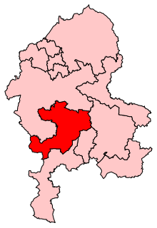
Stafford is a constituency represented in the House of Commons of the UK Parliament since 2010 by Jeremy Lefroy, a Conservative.

The A5127 is a major road in England which runs between Birmingham and Lichfield, Staffordshire. For much of the route the road follows the old route of the A38 which has since been moved in order to by-pass places such as Erdington and Sutton Coldfield and form a relief road from Birmingham city centre to Spaghetti Junction.
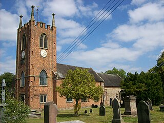
Seighford is a small village about 3 miles (5 km) west of Stafford in Staffordshire, England. The population of this civil parish as taken at the 2011 census was 1,793. The ford across a small stream is the origin of the village's toponym. The village has a red brick Church of England parish church, St Chad's and a 16th-century Tudor mansion.
Stafford Rural District was a rural district in the county of Staffordshire. It was created in 1894 and abolished in 1974 by virtue of the Local Government Act 1972. On formation it contained the following civil parishes:

Burton Abbey at Burton upon Trent in Staffordshire, England, was founded in the 7th or 9th century by St Modwen or Modwenna. It was refounded in 1003 as a Benedictine abbey by the thegn Wulfric Spott. He was known to have been buried in the abbey cloister in 1010, alongside the grave of his wife.
Coton Hill is a hamlet in the English county of Staffordshire.
The Coton Hill rail crash was a train crash which occurred on 11 January 1965, at Coton Hill, near Shrewsbury in Shropshire, England.

Coton Clanford is a small dispersed Staffordshire village lying in gently rolling countryside 3 miles due west of Stafford, England and 1 mile southeast of Seighford. The name of the village is sometimes hyphenated to Coton-Clanford, appearing this way on some cottage names locally. The population for this village as taken at the 2011 census can be found under Seighford. It lies midway between the B5405 road, 1½ miles to the north and the A518 1½ miles to the south. The village has no shops, public houses or church, comprising only a few scattered houses and cottages, several dairy farms and a long disused 19th century chapel.
South Staffordshire College is a further education college located over four sites in Staffordshire, England.
Leyfields is a housing estate in Tamworth, Staffordshire, consisting of 3-storey flats, maisonettes, bungalows and houses. It was built in the 1960s as a postwar housing estate. It joins the Gillway estate, Claremont Road estate and Coton Green.
Meir Heath Cricket Club is a cricket club and ground in Meir Heath, Staffordshire. The first recorded match on the ground was in 1991, when Staffordshire played Shropshire in the grounds only MCCA Knockout Trophy match. In 1992, it held its first Minor Counties Championship match which saw Staffordshire play Suffolk. The following year, the ground held its second and to date final Minor Counties Championship match, which was between Staffordshire and Lincolnshire.
The Griff and Coton Ground is a cricket ground in Nuneaton, Warwickshire. The first recorded match on the ground was in 1930, when it hosted its first first-class match when Warwickshire played Leicestershire in the County Championship. From 1930 to 1989, the ground played host to 26 first-class matches, the last of which was between Warwickshire and Derbyshire.

Chilvers Coton is an area of the town of Nuneaton in Warwickshire, England, around one mile south of the town centre.
Mid Staffordshire Postgraduate Medical Centre is a Medical Education establishment situated in Stafford, England. The Centre is located in the grounds of County Hospital, and opened in 1986.

Chilvers Coton was a railway station on the Coventry to Nuneaton Line, which served the Chilvers Coton area of Nuneaton, south of the town centre. It opened in 1850, along with the line, and was closed in 1965 when passenger services on the route were withdrawn.
Coton Green Football Club is a football club based in Tamworth, Staffordshire, England. They are currently members of the Midland League Division Two and play at New Mill Lane in Fazeley.
Milwich is a civil parish in the Borough of Stafford, Staffordshire, England. It contains 13 listed buildings that are recorded in the National Heritage List for England. Of these, one is at Grade II*, the middle of the three grades, and the others are at Grade II, the lowest grade. The parish contains the villages of Milwich and Coton, and the surrounding countryside. Most of the listed buildings are houses and farmhouses, the earlier of which are timber framed or have a timber framed core. The other listed buildings are a church, a public house, a former toll house, and a disused watermill.


