
Castle Douglas is a town in Dumfries and Galloway, Scotland. It lies in the lieutenancy area of Kirkcudbrightshire, in the eastern part of Galloway, between the towns of Dalbeattie and Gatehouse of Fleet. It is in the ecclesiastical parish of Kelton.

The St. Enoch Centre is a shopping mall located in the city centre of Glasgow, Scotland. The centre is located adjacent to St Enoch Square. The Architects were the GMW Architects. The construction, undertaken by Sir Robert McAlpine, began in 1986, and the building was opened to the public on 25 May 1989. It was officially opened by the then-Prime Minister Margaret Thatcher, in February of the following year.

Buchanan Street is one of the main shopping thoroughfares in Glasgow, the largest city in Scotland. It forms the central stretch of Glasgow's famous shopping district with a generally more upmarket range of shops than the neighbouring streets: Argyle Street, and Sauchiehall Street.

Ardrossan is a town on the North Ayrshire coast in southwestern Scotland. The town has a population of 10,670 and forms part of a conurbation with Saltcoats and Stevenston known as the 'Three Towns'. Ardrossan is located on the east shore of the Firth of Clyde.

St Enoch station was a mainline railway station in the city of Glasgow, Scotland between 1876 and 1966. The hotel was the first building in Glasgow to be fitted out with electric lighting. The station was demolished in 1977.
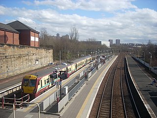
The Paisley Canal line is a branch railway line in Scotland running between Glasgow and Paisley. The line currently terminates at Paisley Canal railway station, although it previously continued through Paisley West station, near Ferguslie, to Elderslie junction where it met and crossed under the main Glasgow and South Western Railway line running from Paisley Gilmour Street station to Johnstone, and beyond. After Elderslie, the line terminated at North Johnstone, however another junction allowed services from the Paisley Canal line to continue onto the Bridge of Weir Railway and Greenock and Ayrshire Railway to the latter's terminus at Greenock Princes Pier.

The Theatre Royal is the oldest theatre in Glasgow and the longest running in Scotland. Located at 282 Hope Street, its front door was originally round the corner in Cowcaddens Street. It currently accommodates 1,541 people and is owned by Scottish Opera. The theatre opened in 1867, adopting the name Theatre Royal two years later. It is also the birthplace of Howard & Wyndham Ltd, owners and managers of theatres in Scotland and England until the 1970s, created by its chairman Baillie Michael Simons in 1895. It was Simons who as a cultural entrepreneur of his day also promoted the building of Kelvingrove Art Gallery and Museum and Glasgow's International Exhibitions of 1888 and 1901.
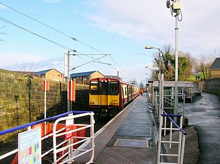
Springburn railway station serves the Springburn district of Glasgow, Scotland. The station is 1+1⁄4 miles (2.0 km) north of Glasgow Queen Street station on the Cumbernauld Line and is a terminus of the Springburn branch, a spur from Bellgrove station, on the North Clyde Line.
The City of Glasgow Union Railway - City Union Line, also known as the Tron Line, was a railway company founded in Glasgow, Scotland, in 1864 to build a line connecting the railway systems north and south of the River Clyde, and to build a central passenger terminus and a general goods depot for the city. The through line, running from south-west to north-east across the city, opened in 1870–1, and the passenger terminal was St Enoch railway station, opened in 1876. The railway bridge across the Clyde was the first in the city.

Bridge Street railway station, now disused, was the original Glasgow terminus of the Glasgow and Paisley Joint Railway; jointly owned by the Glasgow, Paisley and Greenock Railway (GP&G), which later merged with the Caledonian Railway, and the Glasgow, Paisley, Kilmarnock and Ayr Railway (GPK&A), which became part of the Glasgow & South Western Railway.
The Glasgow, Barrhead and Kilmarnock Joint Railway was a railway jointly owned by the Caledonian Railway and the Glasgow and South Western Railway, completed in 1873, and giving the latter a shorter access to its Carlisle main line. A branch to Beith was also built.
The Glasgow St Enoch rail accident occurred on 27 July 1903. A train arriving at the St Enoch terminal station failed to stop in time and collided heavily with the buffer stop, sustaining severe damage. Sixteen people were killed, 13 instantaneously and 3 at a later time due to injuries received. 64 people were injured, of which 17 required hospital treatment. This was the worst buffer stop collision on British main line railways, though exceeded by the Moorgate tragedy on the London Underground.
James Miller (1860–1947) was a Scottish architect, recognised for his commercial architecture in Glasgow and for his Scottish railway stations. Notable among these are the American-influenced Union Bank building at 110–20 St Vincent Street; his 1901–1905 extensions to Glasgow Central railway station; and Wemyss Bay railway station on the Firth of Clyde. His lengthy career resulted in a wide range of building types, and, with the assistance of skilled draughtsmen such as Richard M Gunn, he adapted his designs to changing tastes and new architectural materials and technologies.

Glasgow Cross is at the hub of the ancient royal burgh and now city of Glasgow, Scotland, close to its first crossing over the River Clyde. As a major junction in the city centre, its five streets run: north up the High Street to Glasgow Cathedral, Cathedral Square and the Royal Infirmary; east along Gallowgate and London Road, close to St Andrew's Square; south on the Saltmarket to Glasgow Green and the Justiciary Buildings; and west along Trongate continuing as Argyle Street towards St Enoch Square and Buchanan Street.
The Barrhead Branch was a branch line built by the Glasgow and South Western Railway in Scotland. It connected Potterhill railway station on the south side of Paisley with a new Barrhead Central railway station. The line was sometimes known as the Barrhead Central Railway.

St. Enoch Square is a public square in Glasgow, Scotland, situated south of the junction of Buchanan Street and Argyle Street, two of the city's busiest shopping streets.
Eglinton Street railway station was a railway station approximately one mile south of Glasgow Central, in the Port Eglinton district of Glasgow.
Southside railway station, Glasgow, Scotland, was an early passenger terminal situated in the Gorbals area of the city. The station opened on 29 September 1848, for trains operated by the Glasgow, Barrhead and Neilston Direct Railway, which a short time later was absorbed by the Caledonian Railway.
Main Street railway station, Gorbals, Glasgow, Scotland, was built by the City of Glasgow Union Railway while the new line from Shields Junction to St Enoch station was being developed in the 1870s. It was situated adjacent to Gorbals station, which served trains on the Barrhead branch line to St Enoch, close to where the two lines merged at Gorbals Junction. Remnants of both stations can still be seen in Gorbals Street and Hospital Street.

The Ca d’Oro Building is a commercial building in the Scottish city of Glasgow. The building was made a Category B listed building in 1970 and was then upgraded to Category A in 1988 after being restored from a fire.
