
The North Clyde Line is a suburban railway in West Central Scotland. The route is operated by ScotRail Trains. As a result of the incorporation of the Airdrie–Bathgate rail link and the Edinburgh–Bathgate line, this route has become the fourth rail link between Glasgow and Edinburgh.

The Maryhill Line is a suburban railway line linking central Glasgow and Anniesland via Maryhill in Scotland. It is part of the Strathclyde Partnership for Transport network. The line between Glasgow and Maryhill forms a part of the West Highland Line and was reopened to stopping passenger services in 1993. The line was reopened by British Rail and Strathclyde Passenger Transport Executive. Local services over the route had previously ended in the early 1960s, though it remained open thereafter for Fort William/Mallaig & Oban trains and freight traffic. In 2005 it was extended to Anniesland via a new station at Kelvindale in the north west of the city.

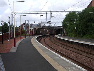
Maryhill railway station is a railway station serving the Maryhill area of Glasgow, Scotland. It is located on the Maryhill Line, 4+3⁄4 miles (7.6 km) northwest of Glasgow Queen Street, a short distance east of Maryhill Viaduct and Maryhill Park Junction. It has two side platforms. Services are provided by ScotRail on behalf of Strathclyde Partnership for Transport.

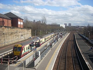
Anniesland railway station is a railway station that serves the Anniesland suburb of Glasgow, Scotland.

Kelvindale railway station is a railway station that serves the Kelvindale suburb of Glasgow, Scotland. It was opened on 26 September 2005 by Bill Butler, the then Member of Parliament in the Scottish Parliament and Councillor Alistair Watson. A bronze plaque records the event. The station is 5+1⁄2 miles (8.9 km) north of Glasgow Queen Street on the Maryhill Line.

Westerton railway station is a railway station that serves the Westerton district in the town of Bearsden, Scotland. The station is managed and served by ScotRail as part of the Strathclyde Partnership for Transport network. It is located on the Argyle and North Clyde lines, between Drumchapel to the west, Bearsden to the north, and Anniesland and Maryhill to the south-east. It is 6 miles 10 chains (9.9 km) west of Glasgow Queen Street, measured via Maryhill.

Bishopbriggs railway station is a railway station serving Bishopbriggs in East Dunbartonshire, Scotland. It is located on the Glasgow to Edinburgh via Falkirk Line, 3+1⁄4 miles (5.2 km) north of Glasgow Queen Street, but is currently only served by services on the Croy Line.

Gilshochill railway station is a railway station serving the Gilshochill, Maryhill and Cadder areas of Glasgow, Scotland. The station is located on the Maryhill Line, 31⁄4 miles (5 km) north west of Glasgow Queen Street. Services are provided by ScotRail on behalf of Strathclyde Partnership for Transport. When the station was opened by British Rail in December 1993 it was named Lambhill, being renamed Gilshochill on 24 May 1998 under Railtrack.

Possilpark & Parkhouse railway station serves the Possilpark and Parkhouse areas of Glasgow, Scotland. It is located on the Maryhill Line, 3 miles (5 km) north of Glasgow Queen Street. Services are provided by ScotRail on behalf of Strathclyde Partnership for Transport.

Ashfield railway station is a railway station serving the Milton and Parkhouse areas of Glasgow, Scotland. It is located on the Maryhill Line, 2+1⁄2 miles (4 km) north of Glasgow Queen Street, a short distance west of Cowlairs North Junction. It has two side platforms. Services are provided by ScotRail on behalf of Strathclyde Partnership for Transport (SPT).

Jordanhill railway station is a side-platformed suburban railway station in the Jordanhill area in the West End of Glasgow, Scotland. The station, which is governed by Transport Scotland and managed by ScotRail, lies on the Argyle Line and the North Clyde Line. In operation since 1887, the station stemmed losses for an area that was in decline.
Springburn railway station serves the Springburn district of Glasgow, Scotland. The station is 1+1⁄4 miles (2.0 km) north of Glasgow Queen Street station on the Cumbernauld Line and is a terminus of the Springburn branch, a spur from Bellgrove station, on the North Clyde Line.
The Stobcross Railway was a railway line in Glasgow, Scotland, built by the North British Railway to connect from Maryhill to the new dock being built at Stobcross; the dock became the Queen's Dock, opened in 1877. The line was opened first, in 1874, and gave the North British company access to the north bank of the River Clyde; there was a goods depot at Partick.

Duke Street Railway Station is a railway station in Glasgow, Scotland. The station is managed by ScotRail and is served by trains on the North Clyde Line, 1½ miles (2 km) north east of Glasgow Queen Street.

Bellgrove Railway Station is in the East End of Glasgow, Scotland, serving the city's Calton, Gallowgate and south Dennistoun neighbourhoods. The station is approximately 1 mile (1.6 km) to the east of Glasgow Queen Street, and is managed by ScotRail.
Coatbridge Sunnyside railway station serves the town of Coatbridge in North Lanarkshire, Scotland. The railway station is managed by ScotRail and is located on the North Clyde Line, 9 miles (14 km) east of Glasgow Queen Street.

Cumbernauld railway station serves the town of Cumbernauld, Scotland. The station is managed by ScotRail and is located on the Cumbernauld Line, 14 miles (23 km) north east of Glasgow Queen Street station and the Motherwell to Cumbernauld Line, 11+3⁄4 miles (18.9 km) north of Motherwell. Trains serving the station are operated by ScotRail.
The Glasgow, Dumbarton and Helensburgh Railway was independently sponsored to build along the north of the River Clyde. It opened in 1858, joining with an earlier local line serving Balloch. Both were taken over by the powerful North British Railway in 1865, and for some time the line was the main route in the area. As industry developed other lines were opened to serve it, and the line formed the core of a network in the area.
The Kelvin Valley Railway was an independent railway designed to connect Kilsyth, an important mining town in central Scotland, with the railway network. It connected Kilsyth to Kirkintilloch and thence over other railways to the ironworks of Coatbridge, and to Maryhill, connecting onwards to the Queen's Dock at Stobcross.

Cadder is a neighbourhood in the north of Glasgow, Scotland. Within the Canal ward under Glasgow City Council, historically more closely associated with the Lambhill and Maryhill districts, it is located 5 kilometres (3 mi) north of Glasgow city centre, sited on the route of the Forth and Clyde Canal. Occupying a footprint which is around 800 metres (870 yd) east to west but only 200 metres (220 yd) north to south on a fairly steep incline, the neighbourhood was built in the early 1950s and borders Glasgow Western Necropolis & Crematorium, Lambhill Cemetery and St. Kentigern's RC Cemetery, as well as Possil Marsh at its eastern side.

