
Arrochar and Tarbet railway station is a railway station on the West Highland Line in Scotland. It stands between the villages of Arrochar and Tarbet. It is sited 19 miles 45 chains (31.5 km) from Craigendoran Junction,near Helensburgh,between Ardlui and Garelochhead. ScotRail manage the station and operate most services,with others provided by Caledonian Sleeper.

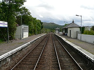
Ardlui railway station is a rural railway station,serving Ardlui at the north end of Loch Lomond,in Scotland. The station is located on the West Highland Line,sited 27 miles 43 chains (44.3 km) from Craigendoran Junction,near Helensburgh,between Crianlarich and Arrochar and Tarbet. ScotRail manage the station and operate most services,others provided by Caledonian Sleeper.
Arisaig railway station serves the village of Arisaig on the west coast of the Highland region of Scotland. This station is on the West Highland Line,measured 32 miles 2 chains (51.5 km) from the former Banavie Junction,near Fort William,between Beasdale and Morar on the way to Mallaig. The westernmost station on the Network Rail network,it is the only one of the four cardinal points of the national network that is not a terminus. ScotRail,who manage the station,operate all services.

Stromeferry railway station is a station on the Kyle of Lochalsh Line,serving the village of Stromeferry in the Highlands,northern Scotland. Stromeferry lies on the southern shore of Loch Carron,across from the ruined Strome Castle,near the west coast. The station is 53 miles 15 chains (85.6 km) from Dingwall,between Attadale and Duncraig. ScotRail,who manage the station,operate all services.

Plockton railway station is a railway station on the Kyle of Lochalsh Line,serving the village of Plockton in the Highlands,north-west Scotland. The station is 58 miles 22 chains (93.8 km) from Dingwall,between Duncraig and Duirinish. ScotRail,who manage the station,operate all services here.

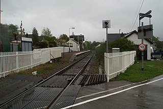
Kyle of Lochalsh railway station is the terminus of the Kyle of Lochalsh Line in the village of Kyle of Lochalsh in the Highlands,northern Scotland. The station is 63 miles 64 chains (102.7 km) from Dingwall. ScotRail,who manage the station,operate all of the services here.
Crianlarich railway station is a railway station serving the village of Crianlarich in Scotland. It is located on the West Highland Line,sited 41 miles 25 chains (66.5 km) from Craigendoran Junction,near Helensburgh,with Ardlui to the south,and Tyndrum Lower and Upper Tyndrum to the north west,on the routes to Oban and Mallaig respectively,which diverge immediately north of the station. ScotRail,who manage the station,operate most services.

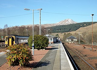
Bridge of Orchy railway station is a railway station in the village of Bridge of Orchy in the west of Scotland. The station is on the West Highland Line,between Rannoch and Upper Tyndrum,48 miles 68 chains (78.6 km) from Craigendoran Junction,near Helensburgh. ScotRail manage the station and operate most services,with others provided by Caledonian Sleeper.
Tulloch railway station is a rural railway station in the remote Tulloch area of the Highland region of Scotland. This station is on the West Highland Line,between Corrour and Roy Bridge,sited 81 miles 59 chains (131.5 km) from Craigendoran Junction,near Helensburgh.

Roy Bridge railway station is a railway station serving the village of Roybridge in the Highland region of Scotland. This station is on the West Highland Line,between Tulloch and Spean Bridge,sited 87 miles 35 chains (140.7 km) from Craigendoran Junction,near Helensburgh. ScotRail manage the station and operate most services,along with Caledonian Sleeper.
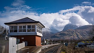
Banavie railway station is a railway station on the West Highland Line serving the village of Banavie,although it is much closer to Caol,Scotland. It is sited between Corpach and Fort William,0 miles 22 chains (0.44 km) from Banavie Junction,just north of Fort William. To continue on to the next station at Corpach,trains must pass over the Caledonian Canal at Neptune's Staircase,a popular tourist attraction. ScotRail provide all services at,and manage,the station.
Corpach railway station is a railway station serving the village of Corpach in the Highland region of Scotland. This station is on the West Highland Line,between Banavie and Loch Eil Outward Bound,and is sited 1 mile 30 chains (2.2 km) from Banavie Junction,near Fort William. ScotRail,who manage the station,operate all services.

Locheilside railway station is a railway station on the northern shore of Loch Eil in the Highland Council Area of Scotland. This station is on the West Highland Line,between Glenfinnan and Loch Eil Outward Bound,located 7 miles 79 chains (12.9 km) from the former Banavie Junction near Fort William. ScotRail,who manage the station,operate all services.

Glenfinnan railway station is a railway station serving the village of Glenfinnan in the Highland council area of Scotland. It is on the West Highland Line,between Lochailort and Locheilside,located 14 miles 58 chains (23.7 km) from the former Banavie Junction. Glenfinnan Viaduct is about 0.7 miles (1 km) to the east of the station. ScotRail,who manage the station,operate all services.

Lochailort railway station is a railway station serving the village of Lochailort in the Highland Council area in Scotland. This station is on the West Highland Line,between Glenfinnan and Beasdale,28 miles 49 chains (46.0 km) from the former Banavie Junction. ScotRail manage the station and operate all services.

Beasdale railway station is a railway station serving Glen Beasdale in the Highland region of Scotland. This station is on the West Highland Line,sited 28 miles 49 chains (46.0 km) from the former Banavie Junction,between Lochailort and Arisaig. ScotRail manage the station and operate all services.

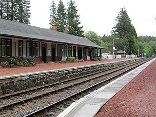
Mallaig railway station is a railway station serving the ferry port of Mallaig,Lochaber,in the Highland region of Scotland. This station is a terminus on the West Highland Line,41 miles (66 km) by rail from Fort William and 164 miles (264 km) from Glasgow Queen Street. The station building is Category C listed. ScotRail,who manage the station,operate most of the services.

Garelochhead railway station is a railway station serving the village of Garelochhead,on the Gare Loch,in Scotland. This station is on the West Highland Line and is a boundary station for SPT. It is sited 8 miles 76 chains (14.4 km) from Craigendoran Junction,near Helensburgh,between Arrochar and Tarbet and Helensburgh Upper. ScotRail manage the station and operate most services,with others provided by Caledonian Sleeper.

Loch Awe railway station is a railway station serving the village of Lochawe,on the northern bank of Loch Awe,in western Scotland. This station is on the Oban branch of the West Highland Line,originally part of the Callander and Oban Railway. It is sited 49 miles 48 chains (79.8 km) from Callander via Glen Ogle,between Dalmally and Falls of Cruachan. ScotRail manage the station and operate all services.

Carrbridge railway station serves the village of Carrbridge,Highland,Scotland. The railway station is managed by ScotRail and is on the Highland Main Line,90 miles from Perth,between Aviemore and Inverness.

