View looking south showing the flatness of the Delaware Basin. Image from the Walnut Canyon drive, Carlsbad Caverns National Park
By earliest Permian time, during the WolfcampianEpoch, the ovoid shaped subsiding Delaware Basin extended over 10,000 square miles (26,000km2) in what is now western Texas and southeast New Mexico.[1]:193§1 This period of deposition left a thickness of 1,600 to 2,200 feet (490 to 670m) of limestone interbedded with dark-colored shale.[1]:193§1
A narrow outlet that geologists call the Hovey Channel periodically supplied new seawater from the Panthalassa Ocean to the west. The somewhat smaller and shallower Midland Basin was just east and the much smaller Marfa Basin was to the southwest. All three basins were south of the equator, north of the Ouachita Mountains of mid-Texas, and part of the northern continent Laurasia.[2] Structurally the Delaware, Midland and Marfa were foreland basins created when the Ouachita Mountains were uplifted as the southern continent Gondwana collided with Laurasia, forming the supercontinent Pangea in the Late Carboniferous (Pennsylvanian).[3] The Ouachita Mountains formed a rainshadow over the basins, and a warm shallow sea flooded the surrounding area. On the other side of the equator, the Ancestral Rocky Mountains formed a large mountainous island.
The Delaware Basin temporarily stopped subsiding in the Leonardian Epoch at the start of the mid-Permian. Small banks along its margin developed along with small discontinuous patch reefs in the shallow water just offshore. The first formation that resulted was the Yeso and consists of alternating beds of dolomitic limestone, gypsum, and sandstone. The sediments responsible for creating the Yeso were deposited in nearshore areas that graded into the carbonate banks of the Victorio Peak Formation in the deeper waters. Thin-bedded limestones of the Bone Spring Formation accumulated as limy ooze in the stagnant deepest part of the basin.[1]:194§2
Subsidence of the Delaware Basin restarted later in the mid Permian and by the Guadalupian Epoch of the upper Permian the patch reefs had grown larger. Sediments deposited close to the shore are now the cherty dolomites of the San Andres Formation while deposition a little further out forms the quartz sandstone and scattered patch reefs of the Brushy Canyon Formation.[1]:194–5§3
Rapid subsidence of the basin started in the middle Guadalupian. Patch reefs responded by rapid (mostly vertical) growth, resulting in the Goat Seep Reef. Three facies developed:
Subsidence of the basin stopped for good by the later part of the Guadalupian. Capitan Reef was the largest in the basin, and it rapidly grew 350 miles (560km) around it. The facies were:[1]:195§5
Fine-grained sand and carbonates deposited near the shore became the dolomites and sandstone of the Artesia Group.
Offshore accumulations of sand and limey ooze in the basin were lithified into sandstone and limestone belonging to the Bell Canyon Formation.
The Capitan Formation consists of Capitan Reef and is made of reef limestone.
Capitan Reef was built primarily from calcareous sponges, encrusting algae such as stromatolites, and directly from seawater as a limey mud. In stark contrast, Cenozoic (current era), Mesozoic (age of the dinosaurs), and even middle Paleozoic (well before the Permian) reefs are mainly composed of corals.[4]
Sea level dropped as the late Permian glaciation intensified and locked increasing amounts of water in distant ice caps. Sedimentation continued to fill the Delaware Basin into the Ochoan Epoch of the upper Permian, periodically cutting the basin off from its source of seawater. Part of the resulting brine became the deep-water evaporites of the Castile Formation. The Castile consists of 1⁄16 inch (1.6mm) thick laminae of alternating gray anhydrite and gypsum, brown calcite, and halite. As the salt concentration increased, halite and potassium-rich salt precipitated from the briny body of water on its margin and on nearshore areas. This salt layer covered an increasingly large area as the water level dropped, forming the Salado Formation.[1]:195§6
The Delaware Basin was filled at least to the top of Capitan Reef and mostly covered by dry land before the end of the Ochoan Epoch. Rivers migrated over its surface and deposited the red silt and sand that now constitute the siltstone and sandstone of the Rustler and Dewey Lake Formations.[1]:195§7,184§3 A karst topography developed as groundwater circulated in the buried limestone formations, dissolving away caverns which were later destroyed by infill and erosion.[1]:184§2
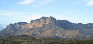
Uplift associated with the Laramide orogeny in the late Mesozoic and early Cenozoic created a major fault along which the Guadalupe Mountains were thrust into existence. The range forms the tilted upthrown part of the system and the Salt Flat Bolson forms the downfallen block.[1]:195§8,184§5Capitan Reef limestone was exposed above the surface with the 1000-foot-high (300m) El Capitan being its most prominent feature. Other large outcrops compose the Apache Mountains and Glass Mountains to the south.[5]
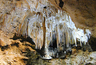
Streams eroded the softer sediment away, lowering the ground level to its current position. Acidic groundwater excavated caves in the limestone of the higher areas and eroded sediment helped fill any remaining Permian-aged caves. Unlike most other caves in limestone, in this case the acid was likely derived from hydrogen sulfide and sulfide-rich brines that were freed by tectonic activity in the mid-Tertiary and mixed with oxygenated groundwater, forming sulfuric acid.[1]:184§5Carlsbad Caverns and nearby modern caves started to form at this time in the groundwater-saturated phreatic zone. Due to the semiarid climate, the karst topography that was created lacks the characteristic depressions, sink holes, pits, and solutional fissures on the surface. Mass wasting such as landslides further reduced topographic relief.
Additional uplift of the Guadalupe Mountains in the Pliocene and early Pleistocene epochs enlarged Carlsbad Cavern and nearby caves. Parts of the major caves emerged from the saturated phreatic zone into the vadose with temporary periods of repose during which additional solutional excavation occurred in the phreatic zone. These pauses in emergence are thought to be responsible for creating the different levels in Carlsbad Caverns. Precipitation of carbon dioxide-rich water that infiltrated into the cavern created speleothems, especially in the humid parts of the Pleistocene. Speleothems found in the "Big Room" of Carlsbad were dated using electron spin resonance dating and were found to be 500,000 to 600,000 years old. This indicates that the Big Room level was dry by that time.[1]:185–6§7
The soft and easily eroded gypsum of the Castile Formation was removed, exposing the Guadalupe Escarpment.[1]:185§7¶1 Additional erosion intersected the upper part of Carlsbad Cavern and other caves, forming their entrances. Drying of cave air has reduced the growth rate of speleothems and encouraged the development of nodular travertine ("cave popcorn").
The Permian Basin is a large sedimentary basin in the southwestern part of the United States. It is the highest producing oil field in the United States, producing an average of 4.2 million barrels of crude oil per day in 2019. This sedimentary basin is located in western Texas and southeastern New Mexico.
Guadalupe Mountains National Park is an American national park in the Guadalupe Mountains, east of El Paso, Texas. The mountain range includes Guadalupe Peak, the highest point in Texas at 8,751 feet (2,667 m), and El Capitan used as a landmark by travelers on the route later followed by the Butterfield Overland Mail stagecoach line. The ruins of a stagecoach station stand near the Pine Springs visitor center. The restored Frijole Ranch contains a small museum of local history and is the trailhead for Smith Spring. The park covers 86,367 acres in the same mountain range as Carlsbad Caverns National Park, about 25 miles (40 km) to the north in New Mexico. The Guadalupe Peak Trail winds through pinyon pine and Douglas-fir forests as it ascends over 3,000 feet (910 m) to the summit of Guadalupe Peak, with views of El Capitan and the Chihuahuan Desert.
El Capitan is a peak in Culberson County, Texas, located within Guadalupe Mountains National Park. The 10th-highest peak in Texas at 8,085 ft, El Capitan is part of the Guadalupe Mountains, an exposed portion of a Permian period reef uplifted and exposed by tectonic activity during the late Cretaceous period. The southern terminus of the Guadalupe Mountains, El Capitan looms over U.S. 62/180, where its imposing height and stark outline have made it one of the iconic images of the Trans-Pecos to generations of travelers.
The Guadalupe Mountains are a mountain range located in West Texas and southeastern New Mexico. The range includes the highest summit in Texas, Guadalupe Peak, 8,751 ft (2,667 m), and the "signature peak" of West Texas, El Capitan, both of which are located within Guadalupe Mountains National Park. The Guadalupe Mountains are bordered by the Pecos River valley and Llano Estacado to the east and north, Delaware Mountains to the south, and Sacramento Mountains to the west. One of the clearest exposures of a prehistoric reef is preserved in the mountain range's bedrock geology. Bedrock contains fossils of reef-dwelling organisms from the Permian period, and the geology is widely studied, mostly by stratigraphers, paleontologists, and Paleoecologists.
The Sacramento Mountains are a mountain range in the south-central part of the U.S. state of New Mexico, lying just east of Alamogordo in Otero County. From north to south, the Sacramento Mountains extend for 85 miles (137 km), and from east to west they encompass 42 miles (68 km).
Texas contains a wide variety of geologic settings. The state's stratigraphy has been largely influenced by marine transgressive-regressive cycles during the Phanerozoic, with a lesser but still significant contribution from late Cenozoic tectonic activity, as well as the remnants of a Paleozoic mountain range.
Carlsbad Caverns National Park is an American national park in the Guadalupe Mountains of southeastern New Mexico. The primary attraction of the park is the show cave Carlsbad Cavern. Visitors to the cave can hike in on their own via the natural entrance or take an elevator from the visitor center.
The English Riviera Geopark (ERG) in Torbay is one of eight UNESCO Global Geoparks in the United Kingdom, and one of over one hundred and seventy worldwide. It is one of only two urban Geoparks in the UK, and joined the Global Geoparks Network on 16 September 2007. The Geopark covers 6,200 hectares of land and 4,100 hectares of sea bed.
A solutional cave, solution cave, or karst cave is a cave usually formed in the soluble rock limestone. It is the most frequently occurring type of cave. It can also form in other rocks, including chalk, dolomite, marble, salt beds, and gypsum.
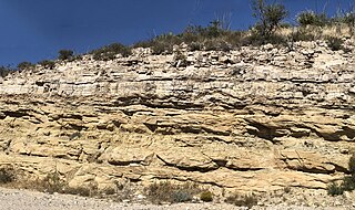
The Cherry Canyon Formation is a geologic formation found in the Delaware Basin of southeastern New Mexico and western Texas. It contains fossils characteristic of the Guadalupian Age of the Permian Period.
The Bell Canyon Formation is a geologic formation found in the Delaware Basin of southeastern New Mexico and western Texas. It contains fossils characteristic of the Guadalupian Age of the Permian Period.
The Capitan Formation is a geologic formation found in western Texas and southeastern New Mexico. It is a fossilized reef dating to the Guadalupian Age of the Permian period.
The Cutoff Formation is a geologic formation in Texas and New Mexico, US. It preserves fossils dating back to the Permian period.
The Seven Rivers Formation is a geologic formation in southeastern New Mexico and west Texas. It preserves fossils dating back to the late Guadalupian Epoch of the Permian period.
The Tansill Formation is a geologic formation in southeastern New Mexico and west Texas, United States. It preserves fossils dating back to the late Guadalupian Age of the Permian period.
The Delaware Mountains are a mountain range in the U.S. state of Texas, spanning part of Culberson County. The highest point in the range is the Delaware Benchmark at an elevation of 5,888 feet (1,795 m) above sea level. The range extends south-southeast from Guadalupe Pass at the southern extent of the Guadalupe Mountains and Guadalupe Mountains National Park. The range is formed by horizontal layers of limestone, sandstone, and shale that were deposited 250 million years ago during the Permian that now encompass the Delaware Mountain Formation. The range is named for the Lenape, who are also known as the Delaware Indians. The Delaware Mountain Wind Energy Center is a 28.5 megawatt wind farm that was constructed on the northern portion of the range in 1999 and is operated by NextEra Energy Resources.
The geology of Arizona began to form in the Precambrian. Igneous and metamorphic crystalline basement rock may have been much older, but was overwritten during the Yavapai and Mazatzal orogenies in the Proterozoic. The Grenville orogeny to the east caused Arizona to fill with sediments, shedding into a shallow sea. Limestone formed in the sea was metamorphosed by mafic intrusions. The Great Unconformity is a famous gap in the stratigraphic record, as Arizona experienced 900 million years of terrestrial conditions, except in isolated basins. The region oscillated between terrestrial and shallow ocean conditions during the Paleozoic as multi-cellular life became common and three major orogenies to the east shed sediments before North America became part of the supercontinent Pangaea. The breakup of Pangaea was accompanied by the subduction of the Farallon Plate, which drove volcanism during the Nevadan orogeny and the Sevier orogeny in the Mesozoic, which covered much of Arizona in volcanic debris and sediments. The Mid-Tertiary ignimbrite flare-up created smaller mountain ranges with extensive ash and lava in the Cenozoic, followed by the sinking of the Farallon slab in the mantle throughout the past 14 million years, which has created the Basin and Range Province. Arizona has extensive mineralization in veins, due to hydrothermal fluids and is notable for copper-gold porphyry, lead, zinc, rare minerals formed from copper enrichment and evaporites among other resources.
The Artesia Group is a group of geologic formations found in southeastern New Mexico and west Texas. These preserve fossils from the Leonardian to Guadalupian Epochs of the Permian Period.
The Grayburg Formation is a geologic formation in west Texas and southern New Mexico. It preserves fossils dating back to the Guadalupian Epoch of the Permian Period.
The Goat Seep Formation is a geologic formation found in western Texas and southeastern New Mexico. It is a fossilized reef dating to the Guadalupian Age of the Permian period.
This page is based on this Wikipedia article Text is available under the CC BY-SA 4.0 license; additional terms may apply. Images, videos and audio are available under their respective licenses.