
Pen-y-clawdd is a village in Monmouthshire, south east Wales, situated between Raglan and Monmouth. The village is the site of a medieval fortification and there is a historic church with an ancient cross in the churchyard which is a scheduled monument.
Monmouth Rugby Football Club is a rugby union club, from Monmouth in South Wales. The club is a member of the Welsh Rugby Union and is a feeder club for the Newport Gwent Dragons.

The Nelson Garden, on 13 Chippenhamgate Street, at the rear of No.18 Monnow Street, Monmouth, Monmouthshire is a 19th-century garden that was the scene of a tea party held to honour Lord Nelson in 1802. The garden is one of 24 sites on the Monmouth Heritage Trail. It is bounded on the south by the line of the medieval town wall through which it is entered via a short underground passageway. The garden has limited public access and is now managed by a trust. It is included on the Cadw/ICOMOS Register of Parks and Gardens of Special Historic Interest in Wales.

The Robin Hood Inn, Nos. 124 and 126, Monnow Street, Monmouth, Monmouthshire, Wales, is a public house of late medieval origins. It was Grade II* listed in 1952.

Hyam's Mineral Water Works is a nineteenth century building at 23 Glendower Street, Monmouth, Wales. Formerly a mineral water works, it is currently used as residential apartments. The building holds one of the 24 blue plaques awarded by the Monmouth Civic Society to buildings of especial historical and social interest, and features on the Monmouth Heritage Trail.
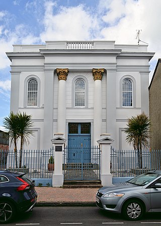
Glendower House, Glendower Street, Monmouth, Wales, is a Victorian former Congregational chapel constructed in a Classical style. The Royal Commission on the Ancient and Historical Monuments of Wales describes it as "a chapel of exceptional sophistication and elaboration of design and one of the earliest Italianate chapels in Wales". It is named after Prince Owain Glyndŵr.
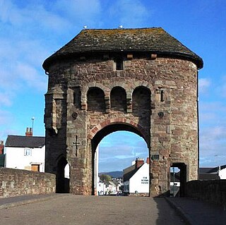
The Monmouth town walls and defences comprise the defensive system of town walls and gates built in Monmouth, Wales between 1297 and the early part of the following century. Wye Bridge Gate, East Gate, Monk's Gate, and Monnow Bridge Gate were access points to the town. West Gate, across Monnow Street, also provided access. Only the Monnow Bridge Gatehouse survives intact, albeit in a substantially modified version from the original.

The Masonic Hall is a grade II listed building on Monk Street in Monmouth, Monmouthshire, Wales. It was designed by architect George Vaughan Maddox. The building is believed to mark the site of Monk's Gate, part of the original defences of the town of Monmouth. Before its 1846 conversion to the Masonic Hall, the building served as the Monk Street Theatre. After more than 150 years of housing the Loyal Monmouth Lodge No. 457, the Masonic Hall sustained fire and smoke damage from suspected arson. The Lodge of Freemasons housed in the building is the oldest surviving Masonic Lodge in Monmouthshire.

Kingsley House and Hendre House are a pair of 19th-century, semi-detached houses on the North Parade section of Monk Street in Monmouth, Monmouthshire, Wales. The grade II listed houses were designed by noted Monmouth architect and builder George Vaughan Maddox, who also designed at least two of the twenty-four blue plaque buildings on the Monmouth Heritage Trail, including the Market Hall and the Monmouth Methodist Church. Hendre House should be distinguished from The Hendre, the estate of the Rolls family.
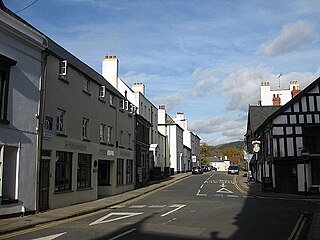
St James Street is a historic street in the town centre of Monmouth, Monmouthshire, Wales. It appears as a segment of Whitecross Street on the 1610 map of the town by cartographer John Speed and is within the medieval town walls. On more recent maps, it extends from St James Square southwest to Almshouse Street. In 2010, the street was the site of discovery of Mesolithic era artefacts. St James Street is lined with numerous listed buildings.

The Grange consists of three attached, grade II listed buildings in Monmouth, Monmouthshire, Wales. It is in the historic St James Street neighbourhood, within the medieval town walls. The Grange was originally built by Captain Charles Philipps at the site of a former farm house. It was the residence of the Kane family and, later, the Windsor family. The buildings also served as a preparatory school, one of the schools of the Haberdashers' Company, until 2009. In 2011, the buildings were converted into a boarding house for students of Monmouth School, another Haberdashers' Company school.

St James House is a grade II listed building in Monmouth, Monmouthshire, Wales. It is in the historic St James Square neighbourhood, within the Medieval town walls. While the house currently has an attractive, 18th-century facade, it originated as a burgage tenement. In addition, behind the house, evidence of a kiln has been unearthed, with both Medieval and Post-medieval pottery. In 2010, archaeological excavation in the square revealed the first evidence of Mesolithic human settlement in Monmouth. Recent residents of St James House have included boarding students from Monmouth School.

Glendower Street is a historic street in the town centre of Monmouth, Monmouthshire, Wales. It extends to the southeast from the intersection of Agincourt Street and St John's Street, within the medieval town walls. Glendower Street is lined with numerous listed buildings, including one of the 24 blue plaque buildings on the Monmouth Heritage Trail.

The Nelson Rooms is a grade II listed building in Monmouth, Monmouthshire, Wales. It is in the historic Glendower Street and Agincourt Street neighbourhood, within the medieval town walls. The building initially served as a gymnasium and was a gift from Lady Llangattock to the town of Monmouth. In 1924, after the benefactor's death, it reopened as the Nelson Museum, and showcased the collection of memorabilia related to Admiral Horatio Nelson that had been amassed by the baroness. The Nelson Museum moved to new quarters at the Market Hall in 1969. The former gymnasium and museum is now an apartment building.

The Crown and Thistle Inn was a public house in Monmouth, Monmouthshire, Wales. It was in the historic Agincourt Square neighbourhood. Prior to its conversion to a public house, the building served as the premises of an apothecary. During the early nineteenth century, the Crown and Thistle Inn briefly housed one of the earliest Masonic Lodges in Monmouthshire.

The Monmouth Police Station is a Grade II listed building in the town centre of Monmouth, Monmouthshire, Wales. It is located in Glendower Street, within the medieval town walls. In March 2012, it was announced that the Monmouth Police Station was one of seventeen police stations in South East Wales that would no longer be open to the public.

St John's is a grade II listed building in the town centre of Monmouth, Wales. It is located in Glendower Street within the medieval town walls. The house is most remarkable for the rear of the property which features a Coalbrookdale verandah and formal walled garden that have been separately grade II listed with the Cadw/ICOMOS Register of Parks and Gardens of Special Historic Interest in Wales. The villa's garden is also registered with the Welsh Historic Gardens Trust.
Wye Bridge Ward was one of four wards in the town of Monmouth, Monmouthshire, Wales. Streets in the ward included St Mary's Street, Almshouse Street, St James Street, St James Square, Whitecross Street and Monk Street. The ward existed as a division of the town by the early seventeenth century, and continued into the twentieth century.
Newton Court is a neoclassical house, completed in 1802, situated on the hillside above Dixton, 1 mi (1.6 km) north-east of the town on Monmouth, in Monmouthshire, Wales. It is a Grade II* listed building. The stable block is listed as a Site of Special Scientific Interest (SSSI), noted for as a breeding site for lesser horseshoe bats.

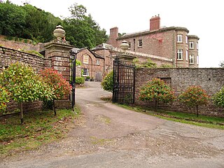
Great Manson Farm is a property on the northern outskirts of Monmouth, Monmouthshire, Wales, in the Buckholt area. It is in the Manson Lane neighbourhood, within the electoral division of Dixton with Osbaston. During the course of the nineteenth and twentieth centuries, members of the Clarke, Goode, Clark, Dampier, and Morgan families resided at Great Manson Farm, at which time the reported size of the farm varied from 170 to 200 acres. The property is remarkable for the presence of three grade II listed buildings, including a barn with medieval origins.

