Southern California is a geographic and cultural region that generally comprises the southern portion of the U.S. state of California. It includes the Los Angeles metropolitan area, the second most populous urban agglomeration in the United States. The region generally contains ten of California's 58 counties: Imperial, Kern, Los Angeles, Orange, Riverside, San Bernardino, San Diego, Santa Barbara, San Luis Obispo and Ventura counties.

The Santa Rosa Mountains are a short mountain range in the Peninsular Ranges system, located east of the Los Angeles Basin and northeast of the San Diego metropolitan area of southern California, in the southwestern United States.

State Route 74, part of which forms the Palms to Pines Scenic Byway or Pines to Palms Highway, and the Ortega Highway, is a state highway in the U.S. state of California. It runs from Interstate 5 in San Juan Capistrano in Orange County to the city limits of Palm Desert in Riverside County. Stretching about 111 miles (179 km), it passes through several parks and National Forests between the Pacific coast and the Coachella Valley.

The Angeles National Forest (ANF) of the U.S. Forest Service is located in the San Gabriel Mountains and Sierra Pelona Mountains, primarily within Los Angeles County in southern California. The ANF manages a majority of the San Gabriel Mountains National Monument.

The Victor Valley is a valley in the Mojave Desert and subregion of the Inland Empire, in San Bernardino County in Southern California.

The San Bernardino Valley is a valley in Southern California located at the south base of the Transverse Ranges. It is bordered on the north by the eastern San Gabriel Mountains and the San Bernardino Mountains; on the east by the San Jacinto Mountains; on the south by the Temescal Mountains and Santa Ana Mountains; and on the west by the Pomona Valley. Elevation varies from 590 feet (180 m) on valley floors near Chino to 1,380 feet (420 m) near San Bernardino and Redlands. The valley floor is home to over 80% of the more than 4 million people in the Inland Empire region.
The Imperial Highway is a west-east thoroughfare in the counties of Los Angeles, Orange, Riverside, San Diego, and Imperial in California. The main portion of the existing route begins at Vista Del Mar in Los Angeles near the Los Angeles International Airport and ends at the Anaheim–Orange city line at Via Escola where it becomes Cannon Street. Historically, the Imperial Highway extended from Vista Del Mar to Calexico, where a portion of the highway still exists. The original route was replaced with other highways, leading the older portions of the Imperial Highway to fall out of use.

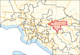
California's 35th congressional district is a U.S. congressional district in California. The district is currently represented by Democrat Norma Torres.

San Timoteo Canyon is a river valley canyon southeast of Redlands, in the far northwestern foothills of the San Jacinto Mountains in the Inland Empire region of Southern California.

The San Jacinto Fault Zone (SJFZ) is a major strike-slip fault zone that runs through San Bernardino, Riverside, San Diego, and Imperial Counties in Southern California. The SJFZ is a component of the larger San Andreas transform system and is considered to be the most seismically active fault zone in the area. Together they relieve the majority of the stress between the Pacific and North American tectonic plates.
Rancho El Rincón was a 4,431-acre (17.93 km2) Mexican land grant in present-day San Bernardino County and Riverside County, California given in 1839 to Juan Bandini by Governor Juan Alvarado. El rincón means "the corner" in Spanish. The grant, located south of present-day Chino, was bounded on the east by Rancho Jurupa, on the south by the Santa Ana River, on the west by Rancho Cañón de Santa Ana, and extending northerly from the river one league. The rancho lands include Prado Regional Park.

San Mateo Creek is a stream in Southern California in the United States, whose watershed mostly straddles the border of Orange and San Diego Counties. It is about 22 miles (35 km) long, flowing in a generally southwesterly direction. Draining a broad valley bounded by the Santa Ana Mountains and Santa Margarita Mountains, San Mateo Creek is notable for being one of the last unchannelized streams in Southern California.

Riverside County is a county located in the southern portion of the U.S. state of California. As of the 2020 census, the population was 2,418,185, making it the fourth-most populous county in California and the 10th-most populous in the United States. The name was derived from the city of Riverside, which is the county seat.
Rancho Potreros de San Juan Capistrano was a 1,168-acre (4.73 km2) Mexican land grant in present-day Orange County and Riverside County, California given in 1845 by Governor Pío Pico to John Forster. The grant was composed of three detached tracts, called, Rancho Potrero los Pinos, Rancho Potrero el Cariso, and Rancho Potrero de la Cienega. The grants were located in the Santa Ana Mountains in the present-day Cleveland National Forest in the southeast corner of the Orange County and western Riverside County.
Bell Mountain is an unincorporated community in the Victor Valley region of the Mojave Desert, within San Bernardino County, southern California.

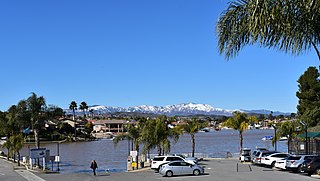
The Elsinore Mountains are a ridge of mountains within the larger range of the Santa Ana Mountains, in the Cleveland National Forest, Riverside County, California, United States. the tallest peaks within the range is the unofficially named San Mateo Peak at 3,591 ft (1,095 m). Second is officially named Elsinore Peak at 3,536 ft (1,078 m). The Elsinore Mountanins run in a ridge from just east of El Cariso, southeast to Elsinore Peak. Beyond that peak the ridge begins to descend and curves to the east. From Elsinore Peak, a ridge runs to the west and then northwest to San Mateo Peak, enclosing the Morrell Potrero on the south and west.
Temescal Valley in California is a graben rift valley in western Riverside County, California, a part of the Elsinore Trough. The Elsinore Trough is a graben between the Santa Ana Mountain Block to the southwest and the Perris Block on the northeast. It is a complex graben, divided lengthwise into several smaller sections by transverse faults. The Temescal Valley is one of these graben, at the northern end of the trough. The Temescal Valley graben is bounded northeast side by the Lee Lake longitudinal fault and similarly on the southeast by the Glen Ivy Fault.
Gavilan Hills, sometimes called the Gavilan Mountains, are a range of the Temescal Mountains, in Riverside County, California. The name given them came from local New Mexican and Californio miners of the mountains and Gavilan Plateau. In Spanish Gavilan, means "sparrow hawk".

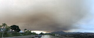
The Holy Fire was a wildfire that burned in the Cleveland National Forest in Orange and Riverside Counties, California. The wildfire started on August 6, 2018 at around 1:15 PM PDT, in the vicinity of Trabuco Canyon. The suspected arsonist, Forrest Gordon Clark, was booked into the Orange County jail in Santa Ana, California. The blaze burned 23,136 acres (94 km2) and destroyed 18 buildings, before it was fully contained on September 13, 2018. While the fire was actively spreading in early and mid-August, residents of the nearby cities of Corona, Temescal Valley, and Lake Elsinore were placed under evacuation orders.

The Loop Fire was a wildfire in Angeles National Forest, above Sylmar, California. Twelve members of the El Cariso Hotshots were killed: 10 died at the scene November 1, 1966; two died later as a result of their injuries while hospitalized.


