Featherstone, Staffordshire

Last updated

Featherstone
Very Patriotic 'Red White and Blue' Public House - geograph.org.uk - 236636.jpg
Red, White and Blue public house
Staffordshire UK location map.svg
Red pog.svg
Featherstone
Location within Staffordshire
Population4,725 (2011 Census) [1]
OS grid reference SJ937050
District
Shire county
Region
Country England
Sovereign state United Kingdom
Post town Wolverhampton
Postcode district WV10
Police Staffordshire
Fire Staffordshire
Ambulance West Midlands
List of places
UK
England
Staffordshire
52°38′36″N2°05′37″W / 52.64347°N 2.09349°W / 52.64347; -2.09349

Featherstone is a town in the district of South Staffordshire, England, near to the border with Wolverhampton.

Contents

History

Originally a farming community consisting of a few scattered farms, it is mentioned in the Domesday Book of 1086 and was owned by the clergy of Wolverhampton Church. It is possible that the population numbers were fairly static until the opening of a new mine, Hilton Main, in the 1920s, it closed in 1969.

The Duke of Cleveland was lord of the manor of this small township of 550 acres and just 34 souls in 1851. This was once the residence of John Huntbach, the noted antiquary. The principal inhabitants were Joshua Price and Edward Tunycliffe, farmers, John Perry the lock manufacturer and Thomas Hill a vermin killer. [2]

The village's population at the time of the 1851 census was 35. By 1921 this had risen to 39. By the time of the 2001 census it was 3,948. [3]

Today

The village has one primary school, Featherstone Academy and a pub, the Red, White and Blue. The latter has recently been closed down and is now available to be rented by new investors.

Recently controversy was sparked over the proposed building of 1,500 houses on green belt land, although many people believed the extra facilities proposed would make the village a better place to live. After much public opposition, this plan was rejected in early 2009.

Featherstone also has a Methodist church and some small shops. There are three off licences, a hairdresser and a chemist. In 2008 there was some concern over the future of the post office, but it was not one of those closed.

On the outskirts of the village are three prisons; HM Prison Featherstone, HM Prison Oakwood and HM Prison Brinsford, which is also a Youth Offender Institution (YOI).

Nearby is the site of the former Brinsford Lodge Teachers' Training College and Polytechnic Hall of Residence. The site of the old college, which stood near Oakwood Prison, is rich in history. There are traces of several old Second World War shelters and tiles from the kitchens.

Schools

Featherstone Academy, the Avenue (formerly Whitgreave Primary School)

Churches

Featherstone is part of the ecclesiastical Parish of Shareshill, where the Parish Church of St Mary & St Luke is situated.

There is a Methodist chapel sited at the junction of the Avenue and the A460.

The village has a regular hourly bus service (service 70, Mon-Sat) to Wolverhampton and Cannock. The bus service is run by D&G Bus trading as Chaserider. In addition Select Bus service 67 runs three times daily Mon-Fri between Wolverhampton and Cannock via Wedge Mills and Bushbury. This latter service also serves Featherstone Prison.

The nearest active railway station to Featherstone is Landywood on the Chase Line and Wolverhampton on the West Coast Main Line.

Political representation

Featherstone has a parish council with two wards.

Featherstone is represented in the House of Commons by Member of Parliament Gavin Williamson, Conservative member for South Staffordshire.

Media

Local news and television programmes are provided by BBC West Midlands and ITV Central. Television signals are received from either the Wrekin [4] or Sutton Coldfield TV transmitters. [5]

Radio stations are served by BBC Radio WM, Heart West Midlands, Smooth West Midlands, Greatest Hits Radio Black Country & Shropshire, Free Radio Black Country & Shropshire, and WCR FM, a community based station which broadcast from nearby Wolverhampton.

The town is served by the local newspaper, Express & Star .

Notable people

See also

Related Research Articles

<span class="mw-page-title-main">West Midlands (county)</span> County of England

West Midlands is a metropolitan and ceremonial county in the larger West Midlands region of England. A landlocked county, it is bordered by Staffordshire to the north and west, Worcestershire to the south, and is surrounded by Warwickshire to the east. The largest settlement is the city of Birmingham.

<span class="mw-page-title-main">Telford</span> Town in Shropshire, England

Telford is a town in Shropshire, England. It is the administrative centre of Telford and Wrekin borough, a unitary authority which covers the town, its suburbs and surrounding settlements. The town is close to the county's eastern boundary, and near the River Severn.

<span class="mw-page-title-main">West Midlands (region)</span> Region of England

The West Midlands is one of nine official regions of England at the first level of International Territorial Level for statistical purposes. It covers the western half of the area traditionally known as the Midlands. The region consists of the counties of Herefordshire, Shropshire, Staffordshire, Warwickshire, West Midlands and Worcestershire. The region has seven cities; Birmingham, Coventry, Hereford, Lichfield, Stoke-on-Trent, Wolverhampton and Worcester.

<span class="mw-page-title-main">Market Drayton</span> Town and civil parish in England

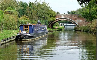
Market Drayton is a market town and civil parish on the banks of the River Tern in Shropshire, England. It is close to the Cheshire and Staffordshire borders. It is located between the towns of Whitchurch, Wem, Nantwich, Newcastle-under-Lyme, Newport and the city of Stoke on Trent. The town is on the Shropshire Union Canal and bypassed by the A53 road.

<span class="mw-page-title-main">Cannock</span> Market town in Staffordshire, England

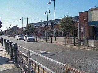
Cannock is a town in the Cannock Chase district in the county of Staffordshire, England. It had a population of 29,018. Cannock is not far from the towns of Walsall, Burntwood, Stafford and Telford. The cities of Lichfield and Wolverhampton are also nearby.

<span class="mw-page-title-main">Willenhall</span> Human settlement in England

Willenhall is a historic market town and civil parish in the Metropolitan Borough of Walsall, and partly in Wolverhampton, in the West Midlands, England, with a population taken at the 2011 census of 28,480. It is situated between Wolverhampton and Walsall, historically in the county of Staffordshire. It lies upon the River Tame, and is part of the Black Country.

<span class="mw-page-title-main">East Staffordshire</span> Non-metropolitan district and Borough in England

East Staffordshire is a local government district with borough status in Staffordshire, England. The council is based in Burton upon Trent. The borough also contains the town of Uttoxeter and numerous villages and surrounding rural areas.

<span class="mw-page-title-main">South Derbyshire</span> Non-metropolitan district in England

South Derbyshire is a local government district in Derbyshire, England. The district covers the towns of Melbourne and Swadlincote as well as numerous villages and hamlets such as Hilton, Hatton, Etwall, Aston-on-Trent, Repton, Weston-on-Trent and Willington. About a third of the National Forest lies within the district.

<span class="mw-page-title-main">South Staffordshire</span> Non-metropolitan district in England

South Staffordshire is a local government district in Staffordshire, England. Its council is based in Codsall. Other notable settlements include Brewood, Cheslyn Hay, Coven, Essington, Featherstone, Four Ashes, Great Wyrley, Huntington, Kinver, Landywood, Penkridge, Perton, Wedge Mills, Weston-under-Lizard and Wombourne. The district covers a largely rural area lying immediately to the west and north-west of the West Midlands conurbation.

<span class="mw-page-title-main">Burntwood</span> Human settlement in England

Burntwood is a former mining town and civil parish in the Lichfield District in Staffordshire, England, approximately 4 miles (6 km) west of Lichfield and north east of Brownhills. The town had a population of 26,049 and forms part of Lichfield district. The town forms one of the largest urbanised parishes in England. Samuel Johnson opened an academy in nearby Edial in 1736. The town is home to the smallest park in the UK, Prince's Park, which is located next to Christ Church on the junction of Farewell Lane and Church Road. The town expanded in the nineteenth century around the coal mining industry.

<span class="mw-page-title-main">Borough of Newcastle-under-Lyme</span> Non-metropolitan district and borough in England

The Borough of Newcastle-under-Lyme is a local government district with borough status in Staffordshire, England.

<span class="mw-page-title-main">Cannock Chase District</span> Non-metropolitan district in England

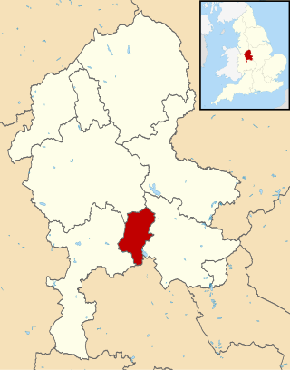
Cannock Chase is a local government district in Staffordshire, England. It is named after and covers a large part of Cannock Chase, a designated Area of Outstanding Natural Beauty. The council is based in the town of Cannock. The district also contains the towns of Hednesford and Rugeley, as well as a number of villages and surrounding rural areas.

<span class="mw-page-title-main">Hednesford</span> Market town in Staffordshire, England

Hednesford is a market town and civil parish in the Cannock Chase district of Staffordshire, England. The Cannock Chase area of natural beauty is to the north of the town. Hednesford is also 1 mile (1.6 km) to the north of Cannock and 5 miles (8.0 km) to the south of Rugeley. The population at the 2011 census was 17,343.

<span class="mw-page-title-main">Kingswinford</span> Human settlement in England

Kingswinford is a town of the Metropolitan Borough of Dudley in the English West Midlands, situated 5 miles (8.0 km) west-southwest of central Dudley. In 2011 the area had a population of 25,191, down from 25,808 at the 2001 Census.

<span class="mw-page-title-main">Cleobury Mortimer</span> Human settlement in England

Cleobury Mortimer is a market town and civil parish in south-east Shropshire, England, which had a population of 3,036 at the 2011 census. It was granted a market charter by King Henry III in 1226.

<span class="mw-page-title-main">Shenstone, Staffordshire</span> Human settlement in England

Shenstone is a village and civil parish in The Lichfield District, Staffordshire, England, located between Lichfield and Sutton Coldfield. The parish also contains the village of Stonnall.

HMP & YOI Prison Brinsford is an adult male Category B & C prison and Young Offenders Institution (YOI), located in the village of Featherstone, in Staffordshire, England. The prison is operated by His Majesty's Prison Service.

<span class="mw-page-title-main">Essington</span> Human settlement in England

Essington is a village and civil parish in South Staffordshire, England, located near the city of Wolverhampton and towns of Walsall, Bloxwich, Cannock and Brewood. The villages of Cheslyn Hay, Great Wyrley, Coven, Penkridge and Featherstone are also nearby. The village forms part of the Staffordshire/West Midlands border.

<span class="mw-page-title-main">Cheslyn Hay</span> Human settlement in England

Cheslyn Hay is a former mining village and civil parish in the South Staffordshire district of Staffordshire, England. It is 3 miles south of Cannock, 10 miles north of Walsall, 9 miles northeast of Wolverhampton, and 13 miles south of Stafford. The village forms a built-up area with the villages and areas of Great Wyrley, Landywood, and Churchbridge.

<span class="mw-page-title-main">HM Prison Oakwood</span>

HM Prison Oakwood is a Category C prison in Featherstone, Staffordshire, England. First opened in April 2012, the prison is operated by G4S and was primed to be in full operation by autumn 2012. Originally called Featherstone 2 and designed to be a titan prison, it was downsized to hold up to 1,605 prisoners with construction starting in August 2009. It was built in a modular fashion, the first time this had been done in the UK.

References

  1. "Civil Parish population 2011" . Retrieved 7 December 2015.
  2. William White, History, Gazetteer and Directory of Staffordshire, 1851, p.154
  3. "KS01 Usual resident population: Census 2001, Key Statistics for urban areas". Office for National Statistics. Archived from the original on 20 August 2011. Retrieved 24 March 2009.
  4. "Full Freeview on the The[sic] Wrekin (Telford and Wrekin, England) transmitter". UK Free TV. 1 May 2004. Retrieved 15 March 2024.
  5. "Sutton Coldfield (Birmingham, England) Full Freeview transmitter". UK Free TV. 1 May 2004. Retrieved 15 March 2024.
  6. SoccerBase Database retrieved 12 August 2018

Commons-logo.svg Media related to Featherstone, Staffordshire at Wikimedia Commons