Folkestone and Hythe is a local government district in Kent, England. It lies in the south-east of the county, on the coast of the English Channel. The district was formed in 1974 and was originally named Shepway after one of the ancient lathes of Kent, which had covered a similar area. The district was renamed in 2018. The council is based in Folkestone, the district's largest town. The district also includes the towns of Hawkinge, Hythe, Lydd and New Romney, along with numerous villages and surrounding rural areas.
The neighbouring districts (anti-clockwise from north-east) are Dover, Canterbury, Ashford and Rother. The latter is in East Sussex, the rest are in Kent. To the south-east is the sea.
History
The modern district was created on 1 April 1974 under the Local Government Act 1972, covering the area of six former districts, which were all abolished at the same time:[2]
The new district was originally named Shepway, after one of the lathes of Kent.[3] The lathe had historically covered a similar, but not identical, area to the modern district; some parts from the north-east of the old lathe are in Dover District, some parts from the north-west are in Ashford Borough.[4]
Map showing the lathe of Shepway in 1900 compared with the district of Shepway in 1974, with the parishes now in Dover and Ashford districts indicated
Lathes were administrative and judicial subdivisions of Kent from Anglo-Saxon times.[5] This lathe had probably originated in the 6th century, during the Jutish colonisation, as the territory of the Limenwara people. It was originally named Lympne after the village where its courts were held, but by the 13th century the lathe's name had been changed to Shepway.[6][7] The court of Shepway, which met at Shepway Cross at Lympne, also played an important role in the administration of the Cinque Ports.[8]
The lathes were never formally abolished, but gradually lost their administrative functions from the 17th century onwards. By the end of the 19th century they had no remaining functions.
In 2018 the council voted to change the name of the district, on the basis that the name Shepway only had limited recognition from the public and businesses. It decided to rename the district after its two largest towns, which together have nearly two thirds of the district's population. Supporters of the change argued it would improve awareness of the area and encourage investment and regeneration. The change of name took effect on 1 April 2018.[9][10] The name was already used for the Folkestone and Hythe constituency, created in 1950, which covers a similar area to the district.
The first election to the council was held in 1973, initially operating as a shadow authority before coming into its powers on 1 April 1974. Political control of the council since 1974 has been as follows:[16][17]
Since the last boundary changes in 2015 the council has comprised 30 councillors representing 13 wards, with each ward electing one, two or three councillors. Elections are held every four years.[22]
Premises
The council is based at the Civic Centre on Castle Hill Avenue. The building was completed in 1966 for the old Folkestone Borough Council.[23] In 2020 the council announced that it was considering the possibility of moving to new premises, although it remains at the Civic Centre as at May 2024.[24][25]
Controversies
Undeclared gifts from Lydd Airport
In 2011, Lydd Airport's owners, seeking to expand the airport, gave gifts to councillors that the councillors did not declare.[26]
Otterpool Park planning permission
Folkestone and Hythe District Council was reported to have spent over £50m up to July 2020 on a proposed housing development on the former Folkestone Racecourse site, despite the 10,000 home scheme not having planning permission. The site had been bought for £4m in 2016 by the billionaire Reuben brothers via a British Virgin Islands-registered company 'Cozumel Estates' who then submitted development proposals to the council for approval, in a partnership with the council. The brothers withdrew from the scheme in 2019 and sold the site to the council for £25m in 2020.[27][28] The local authority granted permission for Otterpool Park in 2023.
Geography
Folkestone and Hythe occupies the most southerly part of Kent. It is bounded on the north by Ashford and Canterbury Districts; on the east by Dover District and on the south by the Strait of Dover. The Romney and Walland Marshes cover a good deal of its area to the west; where the North Downs begin to reach the sea there is much more in the way of settlement. Four out of five towns in the District are located along the coast. The district area is the same size as the similarly named Folkestone & Hythe parliamentary constituency, but leaves out the Saxon Shore ward from the neighbouring Borough of Ashford.
Climate
Climate in this area has mild differences between highs and lows, and there is adequate rainfall year-round. The Köppen Climate Classification subtype for this climate is "Cfb" (Marine West Coast Climate/Oceanic climate).[29]
The layout of the main towns is one of Victorian streets interspersed with apartment blocks, including a few tower blocks with otherwise housing in the district formed of low-rise apartments, semi-detached, terraced or (less often) detached homes with typically smallholdings or small gardens.
The number of listed buildings in the district exceeds 200. This includes 18 churches listed in the highest grading in the national listing system (Grade I). Three castles or their bailey towers survive from the medieval period.
An examples at Grade I is Davison's Mill, a large windmill set by a green rolling lawn.
Economy
In economic terms, Folkestone and Hythe is the third most deprived area in Kent, after Thanet and Swale. Like them, it has a high rate of unemployment; poor educational attainment figures; and with the majority of businesses being small operations.[31] The major source of economy is, however, tourism. Events and venues are widely publicised.[32][33]
Stagecoach South East operate all local buses in the district to Dover, Canterbury, Hastings, Maidstone and Ashford. Stagecoach also run coach route 021 to London from the district on behalf of National Express.
The western end of the Channel Tunnel is at Cheriton, just west of Folkestone and trains that carry cars are provided by Eurotunnel. The tunnel is accessed by the M20 and the A20. Eurostar also use the tunnel but its nearest station to the district is next door in Ashford at Ashford International.
There are no longer cross channel ferry services in the district and these are now concentrated at the Port of Dover..
The Royal Military Canal starts at Seabrook, near the sea at Sandgate, and runs through Hythe town centre and the northern edge of the Romney Marsh.
Lydd Airport is also in this district which handles small passenger flights to Le Touquet in France and Cargo flights to Ostend, Belgium. The Airport is served by routes 11 and 101.
The whole district is divided into civil parishes. The parish councils for Folkestone, Hawkinge, Hythe, Lydd and New Romney take the style "town council". Some of the smaller parishes have a parish meeting rather than a parish council.[35]
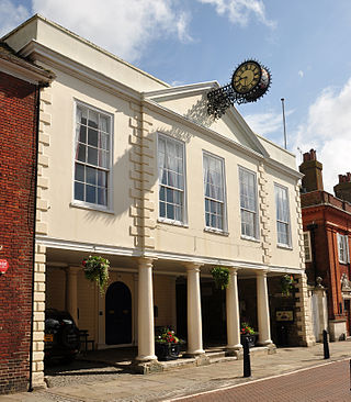
Folkestone is a port town on the English Channel, in Kent, south-east England. The town lies on the southern edge of the North Downs at a valley between two cliffs. It was an important harbour, shipping port and fashionable coastal resort for most part of the 19th and mid 20th centuries.
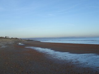
Romney Marsh is a sparsely populated wetland area in the counties of Kent and East Sussex in the south-east of England. It covers about 100 square miles (260 km2). The Marsh has been in use for centuries, though its inhabitants commonly suffered from malaria until the 18th century. Due to its location, geography and isolation, it was a smuggler's paradise between the 1600s and 1800s. The area has long been used for sheep pasture: Romney Marsh sheep are considered one of the most successful and important sheep breeds. Criss-crossed with numerous waterways, and with some areas lying below sea level, the Marsh has over time sustained a gradual level of reclamation, both through natural causes and by human intervention.
The A20 is a major road in south-east England, carrying traffic from London to Dover in Kent. Parts of the route date back to turnpikes established in the early part of the 18th century. The line of the road throughout Kent runs closely in parallel with the M20 motorway.
Hythe is a market town and civil parish on the edge of Romney Marsh, in the district of Folkestone and Hythe in Kent, England. The word Hythe or Hithe is an Old English word meaning haven or landing place.
New Romney is a market town in Kent, England, on the edge of Romney Marsh, an area of flat, rich agricultural land reclaimed from the sea after the harbour began to silt up. New Romney, one of the original Cinque Ports, was once a sea port, with the harbour adjacent to the church, but is now more than a mile from the sea. A mooring ring can still be seen in front of the church. It is the headquarters of the Romney, Hythe and Dymchurch Railway.
Lydd is a town and electoral ward in Kent, England, lying on Romney Marsh. It is one of the larger settlements on the marsh, and the most southerly town in Kent. Lydd reached the height of its prosperity during the 13th century, when it was a corporate member of the Cinque Ports, a "limb" of Romney. Actually located on Denge Marsh, Lydd was one of the first sandy islands to form as the bay evolved into what is now called Romney Marsh.
The Borough of Ashford is a local government district with borough status in Kent, England. It is named after its largest town, Ashford, where the council is based. The borough also includes the town of Tenterden and an extensive surrounding rural area including numerous villages; with an area of 580 square kilometres (220 sq mi), it is the largest district in Kent. Parts of the borough lie within the designated Areas of Outstanding Natural Beauty of High Weald and the Kent Downs.
A lathe formed an administrative country subdivision of the county of Kent, England, from the Anglo-Saxon period, until it fell out of general practical use in the early twentieth century.
Dymchurch is a village and civil parish in the Folkestone and Hythe district of Kent, England. The village is located on the coast five miles (8 km) south-west of Hythe, and on the Romney Marsh.
Folkestone and Hythe is a constituency in Kent represented in the House of Commons of the UK Parliament since 2010 by Damian Collins, a Conservative.
Ashford is a constituency in Kent created in 1885 and represented in the House of Commons of the UK Parliament since 1997 by Damian Green, a Conservative who served as First Secretary of State between 11 June and 20 December 2017.
Ashford is a town in Kent, England, which lies on several major transport routes.
Transportation needs within the county of Kent in South East England has been served by both historical and current transport systems.
Stanford is a village and civil parish in Kent, England. It is part of the Folkestone and Hythe district.
West Hythe is a hamlet and former civil parish, now in the parish of Hythe, in the Folkestone and Hythe district, in Kent, England, near Palmarsh and a few miles west of the cinque port town of Hythe. In 2020 it had an estimated population of 566.
Greatstone is a village on the coast of Romney Marsh in Kent, England. It is east of the town of New Romney and split between the civil parishes of New Romney and Lydd.
Lydd Town was a railway station which served the town of Lydd in Kent, England. Opened on 7 December 1881 by The Lydd Railway Company. It closed to passengers in 1967 but the line through the station remained open for freight.
Folkestone and Hythe District Council is the local authority for the Folkestone and Hythe District in Kent, England. The district was called Shepway prior to 2018. The council is elected every four years. Since the last boundary changes in 2015, 30 councillors have been elected from 13 wards.
KMFM Shepway and White Cliffs Country is an Independent Local Radio station serving the districts of Dover and Folkestone and Hythe and the surrounding areas in Kent, South East England. It is the South Kent region of the KMFM radio network, containing local advertisements and sponsorships for the area amongst a countywide schedule of programming.
↑ See list of parishes by lathe and hundred in the census tables in Victoria County History, Kent Volume 3 (publ.1932, ed William Page, ISBN9780712906081)
↑ "Status details for Lathe". A Vision of Britain through Time. GB Historical GIS / University of Portsmouth. Retrieved 15 May 2024.
This page is based on this Wikipedia article Text is available under the CC BY-SA 4.0 license; additional terms may apply. Images, videos and audio are available under their respective licenses.