Fort Hill State Memorial

Last updated

Fort Hill State Park
Usaohioforthillearthworkssign01.jpg
Entrance sign on SR41
USA Ohio location map.svg
Red pog.svg
Nearest city Sinking Spring, Ohio
Coordinates 39°06′47″N83°24′23″W / 39.1131°N 83.4063°W / 39.1131; -83.4063
Area400 acres (160 ha)
NRHP reference No. 70000500 [1]
Added to NRHPNovember 10, 1970

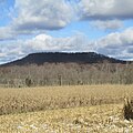
Fort Hill State Memorial is a Native American earthwork located in Highland County, Ohio, United States. Built by the Hopewell culture, it is maintained by the Arc of Appalachia Preserve System and the Ohio History Connection. [2]

Contents

The earthwork, built about 2,000 years ago, is a walled enclosure made of soil on top of a flat summit. It is 500 feet (150 m) higher than nearby portions of Ohio Brush Creek and 800 feet (240 m) higher than the Ohio River. [3] It was made by the Hopewell people. It is over 112 miles in circumference, enclosing 35.3 acres (14.3 ha). Thirty-nine "man-made openings" occur throughout the enclosure: thirty-six that are verified as being made by Indians and three others still unknown as to how they were made. The wall is 6 to 15 feet (1.8 to 4.6 m) high and its total length is 8,619 feet (2,627 m). It is 30 feet (9.1 m) wide at its base in most areas. Archaeologists believe it was not used as a fort, but instead as a religious site. [2]

In 1846, it was excavated by Ephraim George Squier and Edwin Hamilton Davis. It was featured in their book Ancient Monuments of the Mississippi Valley , which was published in 1848. [3]

Fort Hill State Memorial contains excellent outcrops of Silurian, Devonian, and Mississippian sedimentary bedrock and a natural bridge. The site is also an example of glacial stream reversal. It was named a National Natural Landmark in 1974. [4]

See also

Related Research Articles

<span class="mw-page-title-main">Serpent Mound</span> Prehistoric effigy mound in Ohio, United States

The Great Serpent Mound is a 1,348-feet-long (411 m), three-feet-high prehistoric effigy mound located in Peebles, Ohio. It was built on what is known as the Serpent Mound crater plateau, running along the Ohio Brush Creek in Adams County, Ohio. The mound is the largest serpent effigy known in the world.

<span class="mw-page-title-main">Fort Ancient (Lebanon, Ohio)</span> United States historic place

<span class="mw-page-title-main">Hopewell Culture National Historical Park</span> United States national historical park

Hopewell Culture National Historical Park is a United States national historical park with earthworks and burial mounds from the Hopewell culture, indigenous peoples who flourished from about 200 BC to AD 500. The park is composed of four separate sites open to the public in Ross County, Ohio, including the former Mound City Group National Monument. The park includes archaeological resources of the Hopewell culture. It is administered by the United States Department of the Interior's National Park Service.

<i>Ancient Monuments of the Mississippi Valley</i> Book by Ephraim George Squier

Ancient Monuments of the Mississippi Valley (1848) by the Americans Ephraim George Squier and Edwin Hamilton Davis is a landmark in American scientific research, the study of the prehistoric indigenous mound builders of North America, and the early development of archaeology as a scientific discipline. Published in 1848, it was the Smithsonian Institution's first publication and the first volume in its Contributions to Knowledge series. The book had 306 pages, 48 lithographed maps and plates, and 207 wood engravings. The book was reissued in 1998 in paperback, with an introduction by David J. Meltzer, professor of anthropology at Southern Methodist University.

<span class="mw-page-title-main">Fortified Hill Works</span> Archaeological site in Ohio, United States

Fortified Hill Works is a registered historic site near Hamilton, Ohio, listed in the National Register on July 12, 1974.

<span class="mw-page-title-main">Newark Earthworks</span> Archaeological site in Ohio, United States

The Newark Earthworks in Newark and Heath, Ohio, consist of three sections of preserved earthworks: the Great Circle Earthworks, the Octagon Earthworks, and the Wright Earthworks. This complex, built by the Hopewell culture between 100 BCE and 400 CE, contains the largest earthen enclosures in the world, and was about 3,000 acres in total extent. Less than 10 percent of the total site has been preserved since European-American settlement; this area contains a total of 206 acres (83 ha). Newark's Octagon and Great Circle Earthworks are managed by the Ohio History Connection. A designated National Historic Landmark, in 2006 the Newark Earthworks was also designated as the "official prehistoric monument of the State of Ohio."

<span class="mw-page-title-main">Hopeton Earthworks</span> United States historic place

The Hopeton Earthworks are an Ohio Hopewell culture archaeological site consisting of mounds and earthwork enclosures. It is located on the eastern bank of the Scioto River just north of Chillicothe in Ross County, Ohio, about 1 mile (1.6 km) east of the Mound City Group and Shriver Circle on a terrace of the Scioto River. The site is a detached portion of the Hopewell Culture National Historic Park, along with the Mound City Group, Hopewell Mound Group, Seip Earthworks, Spruce Hill Earthworks and the High Bank Works. The site is open to the public.

<span class="mw-page-title-main">Portsmouth Earthworks</span> Archaeological site in Ohio, United States

The Portsmouth Earthworks are a large prehistoric mound complex constructed by the Native American Adena and Ohio Hopewell cultures of eastern North America. The site was one of the largest earthwork ceremonial centers constructed by the Hopewell and is located at the confluence of the Scioto and Ohio Rivers, in present-day Ohio.

<span class="mw-page-title-main">Wolf Plains</span> Archaeological site in Ohio, United States

The Wolf Plains Group is a Late Adena culture group of 30 earthworks including 22 conical mounds and nine circular enclosures. The Plains, originally known as Wolf's Plains, located a few miles to the northwest of Athens, is a relatively flat terrace in an area of hilly terrain in southeastern Ohio's Hocking River valley. The terrace was formed by glacial outwash coming down the Hocking River, which became dammed at The Plains and found a new outlet to the northeast, leaving the terrace in place.

<span class="mw-page-title-main">Mount Horeb Earthworks Complex</span>

The Mount Horeb Earthworks Complex is an Adena culture group of earthworks in Lexington, Kentucky. It consists of two major components, the Mount Horeb Site 1 and the Peter Village enclosure, and several smaller features including the Grimes Village site, Tarleton Mound, and Fisher Mound. The Peter Village and Grimes Village enclosures were mapped by Rafinesque and featured in Squier and Davis's landmark publication Ancient Monuments of the Mississippi Valley in 1848 as Plate XIV Figures 3 and 4.

Highlands Sanctuary, Inc. is a nonprofit organization which operates under the dba of The Arc of Appalachia Preserve System. The Arc of Appalachia has been in operation since 1995, working to create and steward nature preserves in the forested Appalachian counties of southern Ohio. In 2016, The Arc of Appalachia had completed the protection of 4268 acres in 15 preserve regions.

<span class="mw-page-title-main">Marietta Earthworks</span>

The Marietta Earthworks is an archaeological site located at the confluence of the Muskingum and Ohio Rivers in Washington County, Ohio, United States. Most of this Hopewellian complex of earthworks is now covered by the modern city of Marietta. Archaeologists have dated the ceremonial site's construction to approximately 100 BCE to 500 CE.

Howard Baum Site is a Hopewell tradition earthworks site located in Ross County, Ohio, in the United States. The work is located near the north fork of Paint Creek. It was described, in 1848, as "one of the largest and most interesting in the Scioto valley."

<span class="mw-page-title-main">Cedar-Bank Works</span> Archaeological site in Ohio, United States

Cedar-Bank Works is group of Adena culture earthworks located in Ross County, Ohio in the United States. It is located approximately five miles north of the town of Chillicothe, Ohio.

The Junction Group is a site of earthworks located two miles southwest of Chillicothe, Ohio in the United States. The earthworks are associated with the Hopewell tradition. The site has been described as "unusual" by contemporary archaeologists. Excavations in the early 19th-century state that the site was not for fortification, but was used for religious purposes, including for burials.

The Dunlap Works are a group of Hopewell tradition earthworks located in Ross County, Ohio in the United States. It is located approximately 6 miles (9.7 km) north of the city of Chillicothe, Ohio on the left bank of the Scioto River. The site should not be confused with the earthworks in Hamilton County on the Great Miami River near Dunlap's Station, the former site of a pioneer fort.

<span class="mw-page-title-main">Piketon Mounds</span> Archaeological site in Ohio, United States

The Piketon Mounds are a group of earthworks located in Piketon, Ohio in the United States. The site is listed on the National Register of Historic Places. The specific age of the site is unknown. Some mounds were created by the Adena culture, while other mounds were built by the Hopewell culture.

<span class="mw-page-title-main">Cross Mound</span> Archaeological site in Ohio, United States

Cross Mound is an earthwork located near Tarlton, Ohio in the United States. The culture who built it and the time it was built remains unknown. It is listed on the National Register of Historic Places. Contemporary archaeologists have described it as "one of the many enigmatic effigy mounds in Southern Ohio."

<span class="mw-page-title-main">Stubbs Earthworks</span>

The Stubbs Earthworks was a massive Ohio Hopewell culture archaeological site located in Morrow in Warren County, Ohio.

<span class="mw-page-title-main">Shriver Circle Earthworks</span> Ohio Hopewell culture archaeological site

The Shriver Circle Earthworks are an Ohio Hopewell culture archaeological site located in Chillicothe in Ross County, Ohio. At 1,200 feet (370 m) in diameter the site is one of the largest Hopewell circular enclosures in the state of Ohio.

References

  1. "National Register Information System  (#70000500)". National Register of Historic Places . National Park Service. November 2, 2013.
  2. 1 2 "Fort Hill Earthwork - Highland County". Places to Visit. Ohio State University. Retrieved July 29, 2013.
  3. 1 2 Ephraim George Squier; Edwin Hamilton Davis (1848). Ancient Monuments of the Mississippi Valley. Smithsonian Institution. pp. 71–75.
  4. National Registry of Natural Landmarks (June 2009, p. 74. Archived 2011-05-16 at the Wayback Machine Retrieved 25 November 2014.