Fountain Hill, Pennsylvania

Last updated

Borough of Fountain Hill
Lipps & Sutton Silk Mill 02.JPG
Lehigh Valley Silk Mills in Fountain Hill in June 2013
Fountain Hill Seal.png
Motto: 
Lehigh County Pennsylvania Incorporated and Unincorporated areas Fountain Hill Highlighted.svg
Location of Fountain Hill in Lehigh County, Pennsylvania (left) and of Lehigh County in Pennsylvania (right)
USA Pennsylvania location map.svg
Red pog.svg
Fountain Hill
Location of Fountain Hill in Pennsylvania
Usa edcp location map.svg
Red pog.svg
Fountain Hill
Fountain Hill (the United States)
Coordinates: 40°36′03″N75°23′47″W / 40.60083°N 75.39639°W / 40.60083; -75.39639
Country Flag of the United States.svg  United States
State Flag of Pennsylvania.svg  Pennsylvania
County Lehigh
Settled1739
Plotted1866
IncorporatedNovember 13, 1893
Named for Fontainebleau Estate
Government
  MayorMichael Johnson
  Council PresidentStewart McCandless
Area
[1]
   Borough 0.75 sq mi (1.95 km2)
  Land0.73 sq mi (1.90 km2)
  Water0.02 sq mi (0.05 km2)
Elevation
364 ft (111 m)
Population
 (2020) [2]
   Borough 4,832
  Density6,574.15/sq mi (2,536.99/km2)
   Metro
865,310 (US: 68th)
Time zone UTC-5 (EST)
  Summer (DST) UTC-4 (EDT)
ZIP Code
18015
Area codes 610 and 484
FIPS code 42-27008
Primary airport Lehigh Valley International Airport
Major hospital Lehigh Valley Hospital–Cedar Crest
School district Bethlehem Area
Website www.fountainhill.org

Fountain Hill is a borough in Lehigh County, Pennsylvania, United States. The population of Fountain Hill was 4,832 at the 2020 census, an increase over the figure of 4,597 tabulated in 2010. It is part of the Lehigh Valley metropolitan area, which had a population of 861,899 and was the 68th-most populous metropolitan area in the U.S. as of the 2020 census.

Contents

History

The region which would become Fountain Hill was home to Lenape Indians prior to it's acquisition by William Penn for his sons, Thomas, John and Richard in 1681. The Penns would hire a pioneer, Nicholas Doll, to settle the land, building the first structure there in 1739. The deed for the land was passed to several farming families before being sold to the Moravians in the recently established Bethlehem in 1743. [3]

The Moravians would directly own the area which would become Fountain Hill for 32 years, and for 100 years after the purchase the area consisted of non-Moarvian tenant farmer, the largest of which was a 147-acre farm owned by the Hoffert family. The farm house was built in 1755 by Cornelius Weygandt and remains the oldest standing structure in the borough. [3]

In 1846 the Moravians sold 2-acres of the property to Dr. Francis Henry Oppelt who opened a hotel and mineral spa on the site. Oppelt was a staunch believer in balneotherapy, and believed the mineral waters could cure diseases and other ailments. Oppelt's facility would remain open for 25 years from 1846 until 1871. [3]

Oppelt eventually went bankrupt with his resort being sold in a Sheriff Sale to one Tinsley Jeter, who in turn sold it to Asa Packer, founder of Lehigh University in nearby Bethlehem, in 1876. Packer promptly gifted the land to St. Luke's Hospital who moved their hospital from South Bethlehem to the now vacant resort. [3]

In 1848 the Hoffert farm was sold to real estate developers who turned it into a massive mansion named the "Fontainebleau Estate" which would trade ownership several times before 1866 when the estate would also be purchased by Tinsley Jeter who laid a town plot on the property. Jeter at the time was purchasing most of the farms in the region, as well as the mansions built for Lehigh Valley Railroad executives, many of which are preserved in the Fountain Hill Historic District. [3]

In 1866 Jeter was choosing a name for the property and settled on "Fountain Hill", due to the earlier Fontainebleau estate, which stood on a small hill. In 1886 the growing town became the home to several Silk Mills with the birth of the Industrial Revolution. [3]

With the advent of local industry, the regions population surged, however, there was still no incorporated government, with the region operating as a village within Salisbury Township. After a successful petition to the Lehigh County government, Fountain Hill became an incorporated municipality on November 13, 1893. [3]

In 1905 the residents of Fountain Hill rejected a proposal to join the municipality of South Bethlehem (annexed by Bethlehem in 1917) to form an Independent city. [4] In 1919 Fountain Hill annexed some portions of neighboring Salisbury township, and around this time, Fountain Hills most famous resident, Stephen Vincent Benét, began his literary career, publishing his famed poem John Brown's Body in 1929. [3] Through the 1940's Fountain Hill would remain a cultural retreat for Bethlehemites, hosting many operas, playhouses, and theaters. In 1949 Fountain Hill annexed another parcel from Salisbury township, bringing the borough to it's present borders. [5]

Geography

Fountain Hill is located at 40°36′6″N75°23′47″W / 40.60167°N 75.39639°W / 40.60167; -75.39639 (40.601698, -75.396357). [6] According to the U.S. Census Bureau, the borough has a total area of 0.7 square miles (1.8 km2), of which 0.7 square miles (1.8 km2) is land and 1.41% is water. Fountain Hill is approximately 450 acres (1.8 km2), predominantly residential in character, with approximately 1,754 dwelling units. It uses the Bethlehem ZIP code of 18015. [7]

Transportation

Broadway in Fountain Hill 2022-09-26 11 47 29 View southwest along Broadway between Hoffert Street and Bergen Street in Fountain Hill, Lehigh County, Pennsylvania.jpg
Broadway in Fountain Hill
Bridge across the Lehigh River, connecting Fountain Hill with Bethlehem, in June 2013 Railroad Bridge over Lehigh River, Fountain Hill, PA.JPG
Bridge across the Lehigh River, connecting Fountain Hill with Bethlehem, in June 2013

As of 2010, there were 13.60 miles (21.89 km) of public roads in Fountain Hill, of which 0.88 miles (1.42 km) were maintained by the Pennsylvania Department of Transportation (PennDOT) and 12.72 miles (20.47 km) were maintained by the borough. [8]

No numbered highways pass through Fountain Hill. The main thoroughfare through the borough is Broadway, which follows a northeast-southwest alignment through the middle of town. Pennsylvania Route 378 and Pennsylvania Route 412 are the closest numbered highways, both of which pass just to the east of Fountain Hill.

Education

Fountain Hill is served by the Bethlehem Area School District. Fountain Hill Elementary School for kindergarten through grade five is located in Fountain Hill.

Demographics

As of the 2010 census, [9] there were 4,597 people living in the borough. The racial makeup of the borough was 81.4% White, 6.6% African American, 0.1% Native American, 0.8% Asian, 0.0% Pacific Islander, 7.7% from other races, and 3.4% from two or more races. Hispanic or Latino of any race were 22.5% of the population.

Historical population
CensusPop.Note
1900 1,214
1910 1,38814.3%
1920 2,33968.5%
1930 4,56895.3%
1940 4,8045.2%
1950 5,45613.6%
1960 5,428−0.5%
1970 5,384−0.8%
1980 4,805−10.8%
1990 4,637−3.5%
2000 4,614−0.5%
2010 4,597−0.4%
2020 4,8325.1%
2024 (est.)4,690 [10] −2.9%
Sources: [11] [9] [12] [2]

Notable people

Related Research Articles

<span class="mw-page-title-main">Lititz, Pennsylvania</span> Borough in Pennsylvania, United States

Lititz is a borough in Lancaster County, Pennsylvania, United States, 9 miles (14 km) north of the city of Lancaster. As of the 2020 census, it had a population of 9,370.

<span class="mw-page-title-main">Northampton County, Pennsylvania</span> County in Pennsylvania, United States

Northampton County is a county in the Commonwealth of Pennsylvania, United States. As of the 2020 census, the population was 312,951. Its county seat is Easton. The county was formed in 1752 from parts of Bucks County. Its namesake was the county of Northamptonshire in England, and the county seat of Easton was named for Easton Neston, a country house in Northamptonshire.

<span class="mw-page-title-main">Beaver Meadows, Pennsylvania</span> Borough in Pennsylvania, United States

Beaver Meadows is a borough in Carbon County, Pennsylvania, United States. It is part of Northeastern Pennsylvania. The population was 897 at the 2020 U.S. census.

<span class="mw-page-title-main">Lausanne Township, Pennsylvania</span> Place in Pennsylvania, United States

Lausanne Township is a township in Carbon County, Pennsylvania. It is part of Northeastern Pennsylvania. The township dates back to 1808 when the first Lausanne settlement was organized with a local frontier government.

<span class="mw-page-title-main">Lehighton, Pennsylvania</span> Borough in Pennsylvania, United States

Lehighton is a borough in Carbon County, Pennsylvania, United States. It is part of Northeastern Pennsylvania. Lehighton is located 117.2 miles (188.6 km) west of New York City and 77.5 miles (124.7 km) northwest of Philadelphia.

<span class="mw-page-title-main">Emmaus, Pennsylvania</span> Borough in Pennsylvania, United States

Emmaus is a borough in Lehigh County, Pennsylvania. As of the 2020 U.S. census, it had a population of 11,652. Emmaus is located in the Lehigh Valley, the third-largest metropolitan area in Pennsylvania and 68th-largest metropolitan area in the nation.

<span class="mw-page-title-main">Lower Macungie Township, Pennsylvania</span> Township in Pennsylvania, United States

Lower Macungie Township is a township in Lehigh County, Pennsylvania. The township's population was 31,964 as of the 2020 census, making it the second-largest population center in Lehigh County after Allentown and the third-largest population center in the Lehigh Valley metropolitan area after Allentown and Bethlehem.

<span class="mw-page-title-main">Salisbury Township, Lehigh County, Pennsylvania</span> Township in Pennsylvania, United States

Salisbury Township is a township in Lehigh County, Pennsylvania. The township's population was 13,505 at the 2010 census. The township borders Allentown, Pennsylvania's third-largest city, Bethlehem, and Emmaus, in the Lehigh Valley, which had a population of 861,899 and was the 68th-most populous metropolitan area in the U.S. as of the 2020 census.

<span class="mw-page-title-main">Slatington, Pennsylvania</span> Borough in Pennsylvania, United States

Slatington is a borough in Lehigh County, Pennsylvania. As of the 2010 census, it had a population of 4,232. Slatington is located northwest of Allentown and Bethlehem. Slatington is part of the Lehigh Valley metropolitan area, which had a population of 861,899 and was the 68th-most populous metropolitan area in the U.S. as of the 2020 census.

<span class="mw-page-title-main">Upper Saucon Township, Pennsylvania</span> Township in Pennsylvania, United States

Upper Saucon Township is a township in Lehigh County, Pennsylvania. It is part of the Lehigh Valley metropolitan area, which had a population of 861,899 and was the 68th-most populous metropolitan area in the U.S. as of the 2020 census. The township had a population of 16,973 as of the 2020 census.

<span class="mw-page-title-main">Bethlehem Township, Pennsylvania</span> Place in Pennsylvania, United States

Bethlehem Township is a township in Northampton County, Pennsylvania, United States. The population of Bethlehem Township was 23,730 at the 2010 census. It is a suburb of Bethlehem and is part of the Lehigh Valley metropolitan statistical area, which had a population of 861,899 and was the 68th-most populous metropolitan area in the U.S. as of the 2020 census.

<span class="mw-page-title-main">Freemansburg, Pennsylvania</span> Place in Pennsylvania, United States

Freemansburg is a borough in Northampton County, Pennsylvania. The population of Freemansburg was 2,875 as of the 2020 census. The Lehigh River, a 109-mile-long (175 km) tributary of the Delaware River, flows through Freemansburg.

<span class="mw-page-title-main">Hanover Township, Northampton County, Pennsylvania</span> Place in Pennsylvania, United States

Hanover Township is a township in Northampton County, Pennsylvania. The population of Hanover Township was 10,866 at the 2010 census.

<span class="mw-page-title-main">Nazareth, Pennsylvania</span> Place in Pennsylvania, United States

Nazareth is a borough in Northampton County, Pennsylvania, United States. The borough's population was 6,053 at the 2020 census. Nazareth is part of the Lehigh Valley metropolitan area, which had a population of 861,899 and was the 68th-most populous metropolitan area in the U.S. as of 2020.

<span class="mw-page-title-main">Walnutport, Pennsylvania</span> Place in Pennsylvania, United States

Walnutport is a borough in Northampton County, Pennsylvania. It was first incorporated in 1909. The population of Walnutport was 2,067 at the 2020 census.

<span class="mw-page-title-main">West Easton, Pennsylvania</span> Borough in Pennsylvania, United States

West Easton is a borough in Northampton County, Pennsylvania. The population of West Easton was 1,257 at the 2010 U.S. census. West Easton is part of the greater Easton area and the Lehigh Valley metropolitan area, which had a population of 861,899 and was the 68th-most populous metropolitan area in the U.S. as of the 2020 census.

<span class="mw-page-title-main">Bethlehem, Pennsylvania</span> City in Pennsylvania, United States

Bethlehem is a city in Northampton and Lehigh Counties in the Lehigh Valley region of eastern Pennsylvania, United States. As of the 2020 census, Bethlehem had a total population of 75,781, making it the second-largest city in the Lehigh Valley after Allentown and the seventh-largest city in the state. Among its total population as of 2020, 55,639 were in Northampton County and 19,343 were in Lehigh County. The city is located along the Lehigh River, a 109-mile-long (175 km) tributary of the Delaware River.

<span class="mw-page-title-main">Bethlehem Area School District</span> School district in Pennsylvania

Bethlehem Area School District is a large public school district serving the city of Bethlehem and it surrounding boroughs of Fountain Hill and Freemansburg, and Bethlehem and Hanover townships across both Lehigh and Northampton Counties in the Lehigh Valley region of eastern Pennsylvania.

<span class="mw-page-title-main">Gauff Hill, Pennsylvania</span> Unincorporated community in Pennsylvania, U.S.

Gauff Hill is an unincorporated community in the extreme eastern Salisbury Township in Lehigh County, Pennsylvania. It is part of the Lehigh Valley, which has a population of 861,899 and was the 68th-most populous metropolitan area in the U.S. as of the 2020 census.

<span class="mw-page-title-main">Archibald Johnston (Bethlehem)</span>

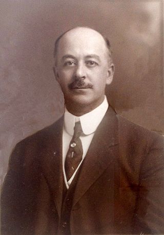
Archibald Johnston was a mechanical engineer who, favored by Bethlehem Iron Company management and senior Bethlehem Steel Company president Charles M. Schwab, became president of Bethlehem Steel Company. He was subsequently appointed as first vice president of the Bethlehem Steel Corporation in charge of foreign sales. While first vice president, he led a municipal consolidation campaign to create the modern city of Bethlehem, Pennsylvania, from the boroughs of Bethlehem and South Bethlehem.

References

  1. "ArcGIS REST Services Directory". United States Census Bureau. Retrieved October 12, 2022.
  2. 1 2 "Census Population API". United States Census Bureau. Retrieved October 12, 2022.
  3. 1 2 3 4 5 6 7 8 "About Fountain Hill". fountainhill.org. Retrieved February 19, 2024.
  4. "Fountain Hill". bapl.org. Retrieved February 19, 2024.
  5. "Fountain Hill's Rich History". bapl.org. Retrieved February 19, 2024.
  6. "US Gazetteer files: 2010, 2000, and 1990". United States Census Bureau. February 12, 2011. Retrieved April 23, 2011.
  7. "18015 ZIPCode Map Bethlehem Pennsylvania - HipCodes.com". www.hipcodes.com. Archived from the original on March 24, 2012. Retrieved August 18, 2022.
  8. "Fountain Hill Borough map" (PDF). PennDOT. Retrieved March 17, 2023.
  9. 1 2 "U.S. Census website". United States Census Bureau . Retrieved January 31, 2008.
  10. "Fountain Hill, Pennsylvania Population 2024 (Demographics, Maps, Graphs)".
  11. "Census of Population and Housing". U.S. Census Bureau. Retrieved December 11, 2013.
  12. "Incorporated Places and Minor Civil Divisions Datasets: Subcounty Resident Population Estimates: April 1, 2010 to July 1, 2012". Population Estimates. U.S. Census Bureau. Archived from the original on June 11, 2013. Retrieved December 11, 2013.