Fogelsville is a village in Lehigh County, Pennsylvania. It is a suburb of Allentown, in Upper Macungie Township, and is part of the Lehigh Valley, which has a population of 861,899 and was the 68th-most populous metropolitan area in the U.S. as of the 2020 census.
Dorneyville is a census-designated place in Lehigh County, Pennsylvania. As of the 2020 census the population was 4,850. Dorneyville is located just west of Allentown in South Whitehall Township and Salisbury Township.

New Tripoli is an unincorporated community and census-designated place (CDP) in Lynn Township in Lehigh County, Pennsylvania. As of the 2020 census, the population was 840. New Tripoli is part of the Lehigh Valley, which had a population of 861,899 and was the 68th-most populous metropolitan area in the U.S. as of the 2020 census.

Summit Lawn is a small unincorporated village that is located in Lehigh County, Pennsylvania. It is part of the Lehigh Valley, which has a population of 861,899 and is the 68th-most populous metropolitan area in the U.S. as of the 2020 census.

Wescosville is a census-designated place located in Lehigh County, Pennsylvania. It is located between Allentown and Trexlertown in Lower Macungie Township. It is part of the Lehigh Valley, which had a population of 861,899 and was the 68th-most populous metropolitan area in the U.S. as of the 2020 census.
Cetronia is a census-designated place (CDP) in South Whitehall Township in Lehigh County, Pennsylvania, located near Allentown. As of the 2020 census, its population was 2,421.

Old Zionsville is an unincorporated community in Upper Milford Township in Lehigh County, Pennsylvania. It is part of the Lehigh Valley, which has a population of 861,899 and is the 68th-most populous metropolitan area in the U.S. as of the 2020 census.
East Texas is a village in Lower Macungie Township in Lehigh County, Pennsylvania. It is part of the Lehigh Valley, which had a population of 861,899 and was the 68th-most populous metropolitan area in the U.S. as of the 2020 census.
Hensingersville, also known as New Hensingersville, is an unincorporated community located mostly in southwestern Lower Macungie Township in Lehigh County, Pennsylvania. It also extends into Longswamp Township in Berks Township near the intersections of Pennsylvania Route 201, Pennsylvania Route 3001, Chestnut Road, and Reservoir Hill Road.
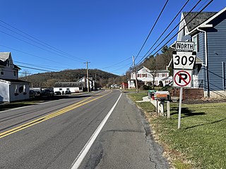
Snyders is an unincorporated community in West Penn Township, Pennsylvania, United States, located at the junction of Routes 309 and 895. The Lizard Creek flows eastward through the village to the Lehigh River. Snyders lies at the northern foot of Blue Mountain and is split between the Andreas ZIP Code 18211 and the New Ringgold ZIP Code 17960. Snyders is served by the Mantzville (386) exchange in Area Code 570.
Andreas is a village in the southeast corner of Schuylkill County, Pennsylvania, in West Penn Township on Route 895. A small part of Andreas is also in East Penn Township in Carbon County. The Lizard Creek flows eastward through the village to the Lehigh River. Andreas lies at the northern foot of Blue Mountain in ZIP Code 18211.
Flicksville is a village located in Northampton County, Pennsylvania. It is located 75 miles (121 km) west of New York City and is part of the Lehigh Valley metropolitan area, which had a population of 861,899 and was the 68th-most populous metropolitan area in the U.S. as of the 2020 census.

Butztown is an unincorporated community in Bethlehem Township, Pennsylvania. It is located northeast of Bethlehem. The village is part of the Lehigh Valley metropolitan area, which had a population of 861,899 and was the 68th-most populous metropolitan area in the U.S. as of the 2020 census.

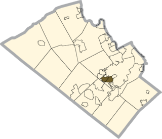
Gauff Hill is an unincorporated community in the extreme eastern Salisbury Township in Lehigh County, Pennsylvania. It is part of the Lehigh Valley, which has a population of 861,899 and was the 68th-most populous metropolitan area in the U.S. as of the 2020 census.

Ackermanville is a census-designated place located on PA Route 191 in Washington Township, Pennsylvania. As of the 2020 census, the village's population was 572. Ackermanville is part of the Lehigh Valley metropolitan area, which had a population of 861,899 and was the 68th-most populous metropolitan area in the U.S. as of the 2020 census. It was named for the Ackerman family.
Beersville, originally known as Falmers, is an exurban unincorporated village in southwestern Moore Township, Pennsylvania near the Lehigh Township line on Route 248. It is part of the Lehigh Valley metropolitan area, which had a population of 861,899 and which was thus the 68th-most populous metropolitan area in the U.S. as of the 2020 census.
Sun Valley is a census-designated place in NW Chestnuthill Township, Monroe County, Pennsylvania on the west side of Route 115 and the south flank of Pohopoco Mountain. The Pohopoco Creek starts in Sun Valley and flows south to Gilbert then west to Beltzville Lake and the Lehigh River. New Jersey Camp Jaycee for people with special needs is located in the CDP, which uses the Effort zip code of 18330. As of the 2010 census the population was 2,399 residents.

Sumneytown is an unincorporated community that is situated on Route 63 in Marlborough Township, Montgomery County, Pennsylvania, United States.
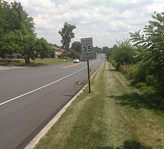
Maxatawny is an unincorporated community located on U.S. Route 222 in Maxatawny Township, Berks County, Pennsylvania, United States, five miles east of Kutztown. It is in the Lehigh watershed and Schaefer Run flows through it to the Little Lehigh Creek. Maxatawny has a post office, with the ZIP code of 19538. Traffic speed on US 222 is reduced to 35 miles-per-hour passing through the village, which borders Lehigh County.
Wysox is an unincorporated community in Bradford County, Pennsylvania, United States. The community is located at the intersection of U.S. Route 6 and Pennsylvania Route 187, 2.3 miles (3.7 km) east of Towanda. Wysox has a post office with ZIP code 18854.


