Gail, Texas

Last updated
Gail, Texas
Borden County Texas Courthouse 2010.jpg
Borden County Courthouse in Gail
Relief map of Texas.png
Red pog.svg
Gail
Coordinates: 32°46′13″N101°26′43″W / 32.77028°N 101.44528°W / 32.77028; -101.44528
Country United States
State Texas
County Borden
Area
  Total2.02 sq mi (5.23 km2)
  Land2.01 sq mi (5.21 km2)
  Water0.008 sq mi (0.02 km2)
Elevation
2,556 ft (779 m)
Population
 (2010)
  Total231
  Density115/sq mi (44.3/km2)
Time zone UTC-6 (Central (CST))
  Summer (DST) UTC-5 (CDT)
ZIP codes
79738
Area code 806

Gail is a census-designated place in and the county seat of Borden County, Texas, United States, that is ocated at the junction of U.S. Route 180 and Farm to Market Road 669. [1] As of the 2010 Census, the population was 231. [2]

Contents

The town and county are named for Gail Borden, Jr., the inventor of condensed milk.

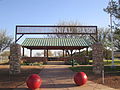
Gail Mountain is located on the southwestern edge of town. The 20th annual Christmas lighting of the star atop Gail Mountain was held on November 29, 2013. [3]

Mushaway Peak, a small but conspicuous butte, is located 4 miles (6 km) southeast.

History

Founded in 1891 to coincide with the organization of Borden County, Gail has served as county seat for the duration of its existence. Borden County had remained quite sparsely populated until 1903, when the locally famed "War of Ribbons", inspired by a state-sanctioned land grab, took place. The conflict took its name from the practice of established ranchers displaying their affiliation and identity by way of a blue ribbon on their sleeves, whereas new settlers to the area designated theirs with a similarly placed red ribbon. By 1910, Gail was home to more than 700 residents, and though this would decline to 600 by 1912, the community remained the economic and administrative hub of Borden County. Changes in agricultural practices and patterns, coupled with the impact of the Great Depression, hindered the town and county's prosperity. By 1936, Gail's population had dwindled to 250 residents, and by 1980, it had fallen to approximately 190. [4] The census of 2010 counted 231 residents in Gail. [2]

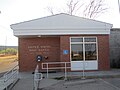
The Borden County Jail opened in 1896. Built at a cost of $4,500 by the Diebold Safe and Lock Company, it had 2-foot-thick (0.61 m) outside walls made of stone from Gail Mountain, and 0.3-foot (0.091 m) hardened steel plates in the cell walls and floor. [5] In 1956, two prisoners objected to Sheriff Sid Reeder's attempt to place them into one of the jail's cells when they noticed a rattlesnake sleeping inside. [6] A historic marker was placed outside the jail in 1967.

John R. "Rich" Anderson, owner of the 64,000-acre (26,000 ha) Muleshoe Ranch near Gail, won the 1992 National Cattleman's Association Environmental Stewardship Award. [7] His achievement was also recognized by the Texas House of Representatives.
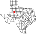
Geography

Gail is located near the center of Borden County. U.S. Route 180 passes through the town, leading east 31 miles (50 km) to Snyder and west 31 miles to Lamesa. Big Spring along FM 669 is 40 miles (64 km) to the south, and Lubbock is 72 miles (116 km) to the north.

According to the U.S. Census Bureau, Gail has an area of 2.0 square miles (5.2 km2), of which 0.008 square miles (0.02 km2), or 0.38%, is covered by water. [2]

Climate

This climate type occurs primarily on the periphery of the true deserts in low-latitude semiarid steppe regions. The Köppen climate classification subtype for this climate is BSk (tropical and subtropical steppe climate). [8]

Climate data for Gail, Texas, 1991–2020 normals, extremes 1912–present
MonthJanFebMarAprMayJunJulAugSepOctNovDecYear
Record high °F (°C)87
(31)
92
(33)
98
(37)
104
(40)
111
(44)
116
(47)
113
(45)
112
(44)
106
(41)
103
(39)
91
(33)
85
(29)
116
(47)
Mean maximum °F (°C)78.1
(25.6)
82.0
(27.8)
88.5
(31.4)
93.9
(34.4)
99.9
(37.7)
102.7
(39.3)
102.5
(39.2)
101.7
(38.7)
97.3
(36.3)
92.4
(33.6)
82.9
(28.3)
76.8
(24.9)
105.7
(40.9)
Mean daily maximum °F (°C)57.1
(13.9)
62.0
(16.7)
70.1
(21.2)
78.8
(26.0)
85.6
(29.8)
91.4
(33.0)
93.6
(34.2)
92.9
(33.8)
85.5
(29.7)
77.2
(25.1)
65.7
(18.7)
57.4
(14.1)
76.4
(24.7)
Daily mean °F (°C)44.6
(7.0)
48.8
(9.3)
56.4
(13.6)
64.4
(18.0)
72.7
(22.6)
79.3
(26.3)
81.9
(27.7)
81.2
(27.3)
73.9
(23.3)
64.3
(17.9)
53.1
(11.7)
45.3
(7.4)
63.8
(17.7)
Mean daily minimum °F (°C)32.2
(0.1)
35.6
(2.0)
42.6
(5.9)
50.0
(10.0)
59.7
(15.4)
67.3
(19.6)
70.2
(21.2)
69.6
(20.9)
62.3
(16.8)
51.5
(10.8)
40.5
(4.7)
33.3
(0.7)
51.2
(10.7)
Mean minimum °F (°C)16.4
(−8.7)
19.4
(−7.0)
24.8
(−4.0)
33.8
(1.0)
44.1
(6.7)
58.3
(14.6)
63.2
(17.3)
62.7
(17.1)
49.1
(9.5)
35.0
(1.7)
24.4
(−4.2)
17.3
(−8.2)
12.1
(−11.1)
Record low °F (°C)3
(−16)
0
(−18)
9
(−13)
24
(−4)
33
(1)
45
(7)
57
(14)
52
(11)
36
(2)
20
(−7)
8
(−13)
−1
(−18)
−1
(−18)
Average precipitation inches (mm)0.55
(14)
0.69
(18)
1.08
(27)
1.36
(35)
2.52
(64)
2.39
(61)
2.00
(51)
2.69
(68)
2.54
(65)
1.78
(45)
1.26
(32)
0.59
(15)
19.45
(495)
Average snowfall inches (cm)0.2
(0.51)
0.2
(0.51)
0.0
(0.0)
0.0
(0.0)
0.0
(0.0)
0.0
(0.0)
0.0
(0.0)
0.0
(0.0)
0.0
(0.0)
0.0
(0.0)
0.0
(0.0)
0.9
(2.3)
1.3
(3.32)
Average precipitation days (≥ 0.01 in)2.02.22.52.94.94.93.63.84.02.71.81.737.0
Average snowy days (≥ 0.1 in)0.00.20.00.00.00.00.00.00.00.00.00.30.5
Source 1: NOAA [9]
Source 2: National Weather Service [10]

Demographics

2020 census

Note: the US Census treats Hispanic/Latino as an ethnic category. This table excludes Latinos from the racial categories and assigns them to a separate category. Hispanics/Latinos can be of any race. [11] [12]

Gail racial composition [13]
(NH = Non-Hispanic)
RaceNumberPercentage
White (NH)20180.72%
Mixed/Multi-Racial (NH)41.61%
Hispanic or Latino 4417.67%
Total249

As of the 2020 United States census, there were 249 people, 38 households, and 24 families residing in the CDP.

Education

Gail is served by the Borden County Independent School District, and is home to the Borden County High School Coyotes. The school's Coyote Stadium is a six-man football venue and can seat 350.

Places of interest

Notable person

Trivia

Gail, Texas, is also the name given to a Census Designated Place which includes the town proper. The town is additionally the locus of the United States Postal Service's Zip Code of 79738.

See also

Related Research Articles

<span class="mw-page-title-main">Borden County, Texas</span> County in Texas, United States

Borden County is a rural county located in the U.S. state of Texas. It is in West Texas and its county seat is Gail.

<span class="mw-page-title-main">Archer City, Texas</span> City in Texas, United States

Archer City is a city in and the county seat of Archer County, Texas, United States. The city lies at the junction of State Highway 79 and State Highway 25. It is located 25 miles (40 km) south of Wichita Falls, and is part of the Wichita Falls metropolitan statistical area. Its population was 1,834 at the 2010 census.

<span class="mw-page-title-main">Claude, Texas</span> City in Texas, United States

Claude is a city in and the county seat of Armstrong County, Texas, United States. The population was 1,196 at the 2010 census. It is located east of Amarillo in the south Texas Panhandle. Claude is part of the Amarillo Metropolitan Statistical Area but is some thirty miles east of Amarillo.

<span class="mw-page-title-main">Burnet, Texas</span> City in Texas, United States

Burnet is a city in and the county seat of Burnet County, Texas, United States. Its population was 6,436 at the 2020 census.

<span class="mw-page-title-main">Baird, Texas</span> City in Texas, United States

Baird is a city and the county seat of Callahan County, Texas, United States. Its population was 1,479 at the 2020 census. The city is named after Matthew Baird, the owner and director of the Texas and Pacific Railway. The railway depot is now operated as the visitor center and a transportation museum.

<span class="mw-page-title-main">Paducah, Texas</span> Town in Texas, United States

Paducah is a town in Cottle County, Texas, United States. The population was 1,186 at the 2010 census, down from 1,498 in 2000. It is the county seat of Cottle County. It is just south of the Texas Panhandle and east of the Llano Estacado.

<span class="mw-page-title-main">Ozona, Texas</span> Census-designated place in Texas, United States

Ozona is an unincorporated community and census-designated place (CDP) that serves as the county seat of Crockett County, Texas, United States. The population was 3,225 at the time of the 2010 census. Ozona is the only Census Bureau–recognized community in Crockett County, which is named for Colonel Davy Crockett, a hero of the Alamo.

<span class="mw-page-title-main">Roby, Texas</span> City in Texas, United States

Roby is a city in and the county seat of Fisher County, Texas, United States. The population was 591 at the 2020 census.

<span class="mw-page-title-main">Pearsall, Texas</span> City in Texas, United States

Pearsall is a city in and the county seat of Frio County, Texas, United States. The population was 7,325 at the 2020 census, down from 9,146 at the 2010 census.

<span class="mw-page-title-main">Hamilton, Texas</span> City in Texas, United States

Hamilton is a city in and the county seat of Hamilton County, Texas, United States, located in the state's central region. Its population was 2,895 at the 2020 census.

<span class="mw-page-title-main">Crosby, Texas</span> Census-designated place in Texas, United States

Crosby is a census-designated place in Harris County, Texas, United States. The population was 3,417 at the 2020 census.

<span class="mw-page-title-main">Sierra Blanca, Texas</span> County Seat & Unincorporated community in Texas, United States

Sierra Blanca is an unincorporated area in Hudspeth County, Texas, United States. It is also the county seat of the county and the namesake of a census-designated place (CDP) in which it is located. The town is part of the Trans-Pecos region of far West Texas, is located northeast of the Mexican border and is within the Mountain Time Zone. As of the 2020 census, its population was 315.

<span class="mw-page-title-main">Fort Davis, Texas</span> Census-designated place in Texas, United States

Fort Davis is an unincorporated community and census-designated place (CDP) in Jeff Davis County, Texas, United States. The population was 1,201 at the 2010 census, up from 1,050 at the 2000 census. It is the county seat of Jeff Davis County.

<span class="mw-page-title-main">Hebbronville, Texas</span> County seat and Census-designated place in Texas, United States

Hebbronville is a census-designated place (CDP) in and the county seat of Jim Hogg County, Texas, United States. The population was 4,558 at the 2010 census.

<span class="mw-page-title-main">Trent, Texas</span> Town in Texas, United States

Trent is a town in Taylor County, Texas, United States, that was established in 1881. The population was 337 at the 2010 census. It is part of the Abilene, Texas Metropolitan Statistical Area. Trent, Texas was named in honor of West Texas pioneer and cattleman, Isaac Riley Trent.

<span class="mw-page-title-main">Sarita, Texas</span> County seat & Unincorporated community in Texas, United States

Sarita is a census-designated place (CDP) in, and the county seat of Kenedy County, Texas, United States. It is the only settlement of note in the county, and as of the 2010 census had a population of 238.

Garden City is an unincorporated community and census-designated place (CDP) in Glasscock County, Texas, United States. It lies near the center of the county, 27 miles (43 km) south of Big Spring. Garden City serves as the Glasscock county seat, and at the 2020 census had a population of 334. The ZIP code is 79739.

<span class="mw-page-title-main">Mentone, Texas</span> Census-designated place in Texas, United States

Mentone is an unincorporated town in and the county seat of Loving County, Texas, United States. As of 2020, the population was 22, up from a population of 19 in 2010, almost one-quarter of the county's 82 people at the time.

<span class="mw-page-title-main">Knoxville, Georgia</span> Place in Georgia, United States

Knoxville is an unincorporated community and census-designated place in Crawford County, Georgia, United States. It is the county seat of Crawford County. The community is part of the Macon Metropolitan Statistical Area. As of the 2020 census, Knoxville had a population of 65.

<span class="mw-page-title-main">Palo Pinto, Texas</span> CDP in Texas, United States

Palo Pinto is a census-designated place (CDP) and unincorporated community and county seat in Palo Pinto County, Texas, United States. This was a new CDP for the 2010 census with a population of 333.

References

  1. "Find a County". National Association of Counties. Archived from the original on 2011-05-31. Retrieved 2011-06-07.
  2. 1 2 3 "Geographic Identifiers: 2010 Demographic Profile Data (G001): Gail CDP, Texas". U.S. Census Bureau, American Factfinder. Archived from the original on February 12, 2020. Retrieved April 15, 2014.
  3. Tai Kreidler, executive director, West Texas Historical Association, "The Twentieth Annual Lighting of the Star on Gail Mountain", November 11, 2013
  4. Hunt, William R. "GAIL, TX". Texas State Historical Association.
  5. "Borden County Jail". AllAcrossTexas.com.[ permanent dead link ]
  6. "Rattler Killed in Texas Jail". St. Joseph News-Press. Oct 14, 1956.
  7. Sasser, Ray (Feb 21, 1993). "Texas Cattleman's Land Management has Wide-Ranging Effect". Dallas News.
  8. Climate Summary for Gail, Texas
  9. "U.S. Climate Normals Quick Access – Station: Gail, TX". National Oceanic and Atmospheric Administration. Retrieved May 3, 2023.
  10. "NOAA Online Weather Data – NWS Midland". National Weather Service. Retrieved May 3, 2023.
  11. https://www.census.gov/ [ not specific enough to verify ]
  12. "About the Hispanic Population and its Origin". www.census.gov. Retrieved 18 May 2022.
  13. "Explore Census Data". data.census.gov. Retrieved 2022-05-18.

Commons-logo.svg Media related to Gail, Texas at Wikimedia Commons