Fort Davis, Texas

Last updated

Fort Davis, Texas
The Jeff Davis County Courthouse, Fort Davis, Texas 2.JPG
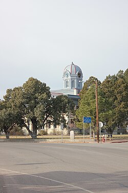
Jeff Davis County Courthouse, located in Fort Davis
JeffDavis County FortDavis.svg
Location of Fort Davis, Texas
Coordinates: 30°35′34″N103°53′31″W / 30.59278°N 103.89194°W / 30.59278; -103.89194
Country United States
State Texas
County Jeff Davis
Area
  Total10.1 sq mi (26.1 km2)
  Land10.1 sq mi (26.1 km2)
  Water0.0 sq mi (0.0 km2)
Elevation
4,892 ft (1,491 m)
Population
 (2010)
  Total1,201
  Density119/sq mi (46.0/km2)
Time zone UTC-6 (Central (CST))
  Summer (DST) UTC-5 (CDT)
ZIP code
79734
Area code 432
FIPS code 48-26688 [1]
GNIS feature ID1357584 [2]

Fort Davis is an unincorporated community and census-designated place (CDP) in Jeff Davis County, Texas, United States. The population was 1,201 at the 2010 census, [3] up from 1,050 at the 2000 census. It is the county seat of Jeff Davis County. [4]

Contents

History

It was the site of Fort Davis, established in 1854 on the San Antonio–El Paso Road through west Texas and named after Jefferson Davis, who was then the Secretary of War under President Franklin Pierce. [5] It was reestablished in 1867 following the civil war. [6] [7]

Geography

Fort Davis is located in southeastern Jeff Davis County at the southeastern foot of the Davis Mountains. Texas State Highway 17 (State Street) passes through the center of town, leading northeast 38 miles (61 km) to Interstate 10 at Balmorhea and southwest 21 miles (34 km) to Marfa. Texas State Highway 118 joins Highway 17 through the center of Fort Davis, but leads northwest through the Davis Mountains 52 miles (84 km) to Interstate 10 and southeast 23 miles (37 km) to Alpine.

According to the United States Census Bureau, the CDP has a total area of 10.1 square miles (26.1 km2), all land. [3]

Fort Davis has the highest elevation above sea level of any county seat in Texas; the elevation is 4,900 feet (1,500 m).

Climate

Fort Davis experiences a semi-arid climate (Köppen BSk) with cool, dry winters and hot, wet summers. There is a large degree of diurnal temperature variation due to the high elevation of the area.

Climate data for Fort Davis, Texas, 1991–2020 normals, extremes 1902–present
MonthJanFebMarAprMayJunJulAugSepOctNovDecYear
Record high °F (°C)90
(32)
86
(30)
90
(32)
97
(36)
102
(39)
107
(42)
103
(39)
104
(40)
101
(38)
100
(38)
95
(35)
79
(26)
107
(42)
Mean maximum °F (°C)74.4
(23.6)
78.0
(25.6)
84.2
(29.0)
88.9
(31.6)
95.6
(35.3)
99.7
(37.6)
97.5
(36.4)
95.8
(35.4)
92.9
(33.8)
88.8
(31.6)
80.5
(26.9)
74.6
(23.7)
100.8
(38.2)
Average high °F (°C)61.8
(16.6)
66.5
(19.2)
72.6
(22.6)
80.2
(26.8)
86.9
(30.5)
91.8
(33.2)
90.0
(32.2)
88.8
(31.6)
84.4
(29.1)
79.3
(26.3)
69.2
(20.7)
62.3
(16.8)
77.8
(25.5)
Daily mean °F (°C)46.3
(7.9)
50.4
(10.2)
56.3
(13.5)
63.4
(17.4)
71.0
(21.7)
77.6
(25.3)
77.2
(25.1)
75.9
(24.4)
71.0
(21.7)
63.6
(17.6)
53.5
(11.9)
47.2
(8.4)
62.8
(17.1)
Average low °F (°C)30.8
(−0.7)
34.4
(1.3)
39.9
(4.4)
46.6
(8.1)
55.1
(12.8)
63.4
(17.4)
64.4
(18.0)
63.1
(17.3)
57.6
(14.2)
47.9
(8.8)
37.7
(3.2)
32.1
(0.1)
47.8
(8.7)
Mean minimum °F (°C)14.7
(−9.6)
16.5
(−8.6)
22.2
(−5.4)
29.7
(−1.3)
39.9
(4.4)
51.9
(11.1)
56.0
(13.3)
54.1
(12.3)
44.3
(6.8)
29.6
(−1.3)
20.1
(−6.6)
14.1
(−9.9)
11.0
(−11.7)
Record low °F (°C)2
(−17)
0
(−18)
10
(−12)
20
(−7)
26
(−3)
40
(4)
47
(8)
46
(8)
36
(2)
18
(−8)
8
(−13)
0
(−18)
0
(−18)
Average precipitation inches (mm)0.53
(13)
0.41
(10)
0.40
(10)
0.54
(14)
1.19
(30)
2.28
(58)
2.99
(76)
2.65
(67)
2.08
(53)
1.28
(33)
0.57
(14)
0.59
(15)
15.51
(393)
Average snowfall inches (cm)0.8
(2.0)
0.5
(1.3)
0.0
(0.0)
0.0
(0.0)
0.0
(0.0)
0.0
(0.0)
0.0
(0.0)
0.0
(0.0)
0.0
(0.0)
0.1
(0.25)
0.4
(1.0)
0.7
(1.8)
2.5
(6.35)
Average precipitation days (≥ 0.01 in)3.12.42.52.35.18.110.99.78.45.02.83.463.7
Average snowy days (≥ 0.1 in)0.40.20.00.00.00.00.00.00.00.10.20.41.3
Source 1: NOAA [8]
Source 2: National Weather Service [9]

Demographics

Historical population
CensusPop.Note
2000 1,050
2010 1,20114.4%
2020 1,024−14.7%
U.S. Decennial Census [10]

2020 census

Fort Davis racial composition
(NH = Non-Hispanic) [11] [lower-alpha 1]
RaceNumberPercentage
White (NH)54753.42%
Native American or Alaska Native (NH)40.39%
Asian (NH)50.49%
Some Other Race (NH)60.59%
Mixed/Multi-Racial (NH)242.34%
Hispanic or Latino 43842.77%
Total1,024

As of the 2020 United States census, there were 1,024 people, 415 households, and 317 families residing in the CDP.

2000 census

As of the census [1] of 2000, 1,050 people, 415 households, and 298 families resided in the CDP. The population density was 188.2 inhabitants per square mile (72.7/km2). The 525 housing units averaged 94.1 per square mile (36.3/km2). The racial makeup of the CDP was 88.29% White, 0.19% African American, 0.48% Native American, 7.62% from other races, and 3.43% from two or more races. Hispanics or Latinos of any race were 49.33% of the population.

Of the 415 households, 32.0% had children under the age of 18 living with them, 57.6% were married couples living together, 10.6% had a female householder with no husband present, and 28.0% were not families. About 24.3% of all households were made up of individuals, and 9.9% had someone living alone who was 65 years of age or older. The average household size was 2.53 and the average family size was 3.02.

In the CDP, the population was spread out, with 24.7% under the age of 18, 7.4% from 18 to 24, 26.9% from 25 to 44, 25.4% from 45 to 64, and 15.6% who were 65 years of age or older. The median age was 39 years. For every 100 females, there were 102.3 males. For every 100 females age 18 and over, there were 97.3 males.

The median income for a household in the CDP was $25,882, and for a family was $27,955. Males had a median income of $22,500 versus $20,000 for females. The per capita income for the CDP was $14,249. About 20.7% of families and 21.6% of the population were below the poverty line, including 26.3% of those under age 18 and 26.0% of those age 65 or over.

Arts and culture

Points of interest

Education

Dirks-Anderson Elementary School DirksAndersonElementary.JPG
Dirks-Anderson Elementary School

Fort Davis is served by the Fort Davis Independent School District.

All of Jeff Davis County is zoned to Odessa College. [14]

Related Research Articles

<span class="mw-page-title-main">Jeff Davis County, Texas</span> County in Texas, United States

Jeff Davis County is a county in the U.S. state of Texas. As of the 2020 census, its population was 1,996. Its county seat is Fort Davis. The county is named for Jefferson Davis, who served as the 23rd United States Secretary of War in the 1850s, and as President of the Confederate States of America.

<span class="mw-page-title-main">Lakehills, Texas</span> CDP in Texas, United States

Lakehills is a census-designated place (CDP) in Bandera County, Texas, United States. The population was 5,150 at the 2010 census, making it the most populous place in Bandera county. It is part of the San Antonio Metropolitan Statistical Area.

<span class="mw-page-title-main">Cross Mountain, Texas</span> Census-designated place in Texas, United States

Cross Mountain is a census-designated place (CDP) in Bexar County, Texas, United States. The population was 3,944 at the 2020 census, up from 3,124 at the 2010 census. It is part of the San Antonio Metropolitan Statistical Area.

<span class="mw-page-title-main">Scenic Oaks, Texas</span> Census-designated place in Texas, United States

Scenic Oaks is a census-designated place (CDP) in Bexar County, Texas, United States. It is part of the San Antonio Metropolitan Statistical Area. The population was 10,458 at the 2010 census, up from 4,957 at the 2010 census.

<span class="mw-page-title-main">Marathon, Texas</span> CDP in Texas, United States

Marathon is a census-designated place (CDP) in Brewster County, Texas, United States. The population was 470 in 2007, after growing from 455 in 2000, but had decreased to 430 by 2010.

<span class="mw-page-title-main">Stowell, Texas</span> Census-designated place in Texas, United States

Stowell is an unincorporated community and census-designated place (CDP) in Chambers County, Texas, United States. The population was 1,743 at the 2020 census.

<span class="mw-page-title-main">West Odessa, Texas</span> Census-designated place in Texas, United States

West Odessa is an unincorporated area and census-designated place (CDP) in Ector County, Texas, United States, on the west side of the city of Odessa. The population was 22,707 at the 2010 census, up from 17,799 at the 2000 census. It is part of the Odessa metropolitan area.

<span class="mw-page-title-main">Canutillo, Texas</span> Census-designated place in Texas, United States

Canutillo is a census-designated place (CDP) in El Paso County, Texas, United States. The population was 6,321 at the 2010 census. It is part of the El Paso Metropolitan Statistical Area. The ZIP Codes encompassing the CDP area are 79835 and 79932.

<span class="mw-page-title-main">Liberty City, Texas</span> Census-designated place in Texas, United States

Liberty City is a census-designated place (CDP) in Gregg County, Texas, United States. The population was 2,721 at the 2020 census, an increase over the figure of 2,351 tabulated in 2010.

<span class="mw-page-title-main">Redwood, Texas</span> Unincorporated community in Texas, United States

Redwood is an unincorporated community and census-designated place (CDP) in Guadalupe County, Texas, United States. The population was 4,003 at the 2020 census, down from 4,338 at the 2010 census. It is part of the San Antonio Metropolitan Statistical Area.

<span class="mw-page-title-main">Hartley, Texas</span> CDP in Texas, United States

Hartley is a census-designated place (CDP) in Hartley County, Texas, United States. The population was 540 at the 2010 census.

<span class="mw-page-title-main">Oak Trail Shores, Texas</span> Census-designated place in Texas, United States

Oak Trail Shores is an unincorporated community and census-designated place (CDP) in Hood County, Texas, United States. Its population was 2,755 at the 2010 census. It is part of the Granbury micropolitan area as well as the Dallas–Fort Worth metroplex.

<span class="mw-page-title-main">Sierra Blanca, Texas</span> County Seat & Unincorporated community in Texas, United States

Sierra Blanca is an unincorporated area in Hudspeth County, Texas, United States. It is also the county seat of the county and the namesake of a census-designated place (CDP) in which it is located. The town is part of the Trans-Pecos region of far West Texas, is located northeast of the Mexican border and is within the Mountain Time Zone. As of the 2010 census, its population was 553.

<span class="mw-page-title-main">Valentine, Texas</span> Town in Texas, United States

Valentine is a town in Jeff Davis County, Texas, United States. Its population was 134 at the 2010 census, down from 187 at the 2000 census.

<span class="mw-page-title-main">Lipscomb, Texas</span> Census-designated place in Texas, United States

Lipscomb is an unincorporated community and census-designated place (CDP) in Lipscomb County, Texas, United States. It is the Lipscomb county seat. The population was 37 at the 2010 census.

<span class="mw-page-title-main">Deweyville, Texas</span> CDP in Texas, United States

Deweyville is a census-designated place (CDP) in Newton County, on the central eastern border of Texas, United States. The population was 571 at the 2020 census, down from 1,023 at the 2010 census.

<span class="mw-page-title-main">Las Lomas, Texas</span> CDP in Texas, United States

Las Lomas is a census-designated place (CDP) in Starr County, Texas, United States. The population was 3,147 at the 2010 census. Las Lomas is one of several colonias in Starr County, within the Rio Grande Valley region. The name is derived from the community's terrain.

<span class="mw-page-title-main">Inez, Texas</span> CDP in Texas, United States

Inez is a census-designated place (CDP), on Interstate 69/U.S. Highway 59 fifteen miles northeast of Victoria, Texas, near the Jackson County, Texas line in Victoria County, Texas, United States. The population was 2,098 at the 2010 census. It is included in the Victoria, Texas, Metropolitan Statistical Area. The name is that of a daughter of a railroad developer.

<span class="mw-page-title-main">Horseshoe Bay, Texas</span> City in Texas, United States

Horseshoe Bay is a city in Llano and Burnet counties in the U.S. state of Texas.

<span class="mw-page-title-main">Mission Bend, Texas</span> Census-designated place in Texas, United States

Mission Bend is a census-designated place (CDP) around Texas State Highway 6 within the extraterritorial jurisdiction of Houston in Fort Bend and Harris counties in the U.S. state of Texas; Mission Bend is 4 miles (6 km) northwest of the city hall of Sugar Land and 20 miles (32 km) southwest of Downtown Houston. The population was 36,914 at the 2020 census.

References

  1. 1 2 "U.S. Census website". United States Census Bureau . Retrieved January 31, 2008.
  2. "US Board on Geographic Names". United States Geological Survey. October 25, 2007. Retrieved January 31, 2008.
  3. 1 2 "Geographic Identifiers: 2010 Census Summary File 1 (G001): Fort Davis CDP, Texas". American Factfinder. U.S. Census Bureau. Archived from the original on February 13, 2020. Retrieved December 7, 2018.
  4. "Find a County". National Association of Counties. Archived from the original on May 31, 2011. Retrieved June 7, 2011.
  5. "The Davis Mountains of Texas" Archived September 18, 2010, at the Wayback Machine , accessed September 13, 2010
  6. "The First Fort Davis: 1854-1862".
  7. "CIVILIAN EMPLOYEES AT FORT DAVIS" (PDF).
  8. "U.S. Climate Normals Quick Access – Station: FT Davis, TX". National Oceanic and Atmospheric Administration. Retrieved September 2, 2023.
  9. "NOAA Online Weather Data – NWS Midland". National Weather Service. Retrieved September 2, 2023.
  10. "Census of Population and Housing". Census.gov. Retrieved June 4, 2015.
  11. "Explore Census Data". data.census.gov. Retrieved March 5, 2022.
  12. https://www.census.gov/ [ not specific enough to verify ]
  13. "About the Hispanic Population and its Origin". www.census.gov. Retrieved May 18, 2022.
  14. "Sec. 130.193. ODESSA COLLEGE DISTRICT SERVICE AREA".
  1. Note: the US Census treats Hispanic/Latino as an ethnic category. This table excludes Latinos from the racial categories and assigns them to a separate category. Hispanics/Latinos can be of any race. [12] [13]