Rockport, Texas

Last updated

Rockport, Texas
Rockport, Texas.jpg
Rockport flag.png
Nickname: 
The Texas Riviera
TXMap-doton-Rockport.PNG
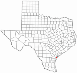
Location of Rockport, Texas
Aransas Rockport.svg
Coordinates: 28°2′55″N97°2′28″W / 28.04861°N 97.04111°W / 28.04861; -97.04111
Country United States
State Texas
County Aransas
IncorporatedAugust 18, 1870 [1]
Government
  MayorLowell Timothy Jayroe
Area
[2]
  Total21.09 sq mi (54.63 km2)
  Land16.55 sq mi (42.85 km2)
  Water4.55 sq mi (11.78 km2)
Elevation
7 ft (2 m)
Population
 (2010)
  Total8,766
  Estimate 
(2019) [3]
10,604
  Density640.88/sq mi (247.45/km2)
Time zone UTC-6 (Central (CST))
  Summer (DST) UTC-5 (CDT)
ZIP codes
78381-78382
Area code 361
FIPS code 48-62804 [4]
GNIS feature ID1345420 [5]
Website www.cityofrockport.com

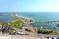
Rockport is a city and county seat of Aransas County, Texas, United States. The population was 8,766 at the 2010 census. [6] [7]

Contents

Rockport is adjacent to the town of Fulton, and many refer to the combined communities as "Rockport-Fulton"; however, Rockport and Fulton are legally separate municipalities.

History

19th Century

Following the Civil War, a number of people considered developing the Live Oak Peninsula. Joseph F. Smith, who had founded the nearby town of St. Mary's in 1850, joined with Thomas H. Mathis and his cousin J.M. Mathis, who were agents of the Morgan Steamship line, and built a wharf at the site of what would later become the town of Rockport, in 1867. The same year, George W. Fulton and his wife, Texas heiress, and Joseph Smith's cousin, Harriet Smith Fulton moved to her extensive land holdings on the peninsula. Fulton also took an interest in the development of Rockport, as well as creating the town of Fulton farther up the coastline. In response, a nascent cattle-slaughtering and packing operation at the wharf expanded rapidly, allowing Rockport to be officially incorporated as a town in 1870; its name arising from the rock ledge that runs along the shore. Thomas Mathis became Rockport's first mayor after being appointed by the governor. [8] A year later in 1871, the town achieved "city" status after continued growth. [9]

In 1871, the Mathis cousins teamed up with local ranching families of George W. Fulton and Thomas M. Coleman to raise and slaughter cattle for shipment out of the city's wharf on their steamship line. The partnership proved highly successful and continued to draw people and businesses to the city. The national Panic of 1873 took its share of the town's prosperity and caused a slump for the next few years. The meatpacking market was slow to recover, and the Mathis cousins abandoned the ranching partnership in 1879. Fulton and Coleman then re-formed their ranching partnership, an organization that continued into the 1930s. For many years Fulton and others petitioned for the railroad to extend their lines to Rockport to provide a second source of transportation and break the Morgan Line's monopoly on the Coastal Bend ports. After offering free rights of way across the Coleman-Fulton ranch, and hundreds of acres in town lots, finally, in 1888 the railroad arrived. The Morgan Steamship company now had competition, and as the local cattle ranchers began shipping live cattle by train, The Morgan Line withdrew from serving the Coastal Bend. Another brief growth spurt began and soon ended, here and across Texas, due to some bad winters and the development of the cattle industry in the mid-west. The railroad, however, brought tourists, and the city's economy grew with several large hotels catering to that industry. Rockport's economy soon came to be dominated by shipbuilding and tourism toward the end of the 19th century. At the same time, the railroad offered speedy transportation for crops, and a land boom caused by farming followed until brought to a halt with the national Panic of 1893. [9]

20th Century

Rockport's economy continued struggling into the early 20th century and took another hit in 1919 when a major hurricane decimated the region. A slow recovery ensued stalling additional development. The city's fortunes however began to improve in 1925 following the establishment of a lucrative shrimping industry which grew further during the 1930s and benefited from the construction of a harbor in 1935. Shrimping activity decreased during World War II but recovered thereafter, boosting the town along with an important boat-building industry that developed in this period as well. By the century's end, shrimping continued to be an important part of the Rockport economy alongside fishing and tourism. [9]

21st Century

On August 25, 2017 Hurricane Harvey (name now retired) [10] made landfall near the city as a Category 4 storm on the Saffir–Simpson scale. [11] Harvey caused one death and catastrophic damage. [12] One person died in a house fire in the city, unable to be rescued due to the extreme weather conditions, [13] entire blocks were destroyed by the hurricane's violent eyewall winds, the city's courthouse was severely damaged when a cargo trailer was hurled into it, coming to a stop halfway through the structure, the gymnasium of the Rockport-Fulton High School lost multiple walls while the school itself suffered considerable damage, [14] many homes, apartment buildings, and businesses sustained major structural damage from the intense winds, and several were completely destroyed. Numerous boats were damaged or sunk at a marina in town, airplanes and structures were destroyed at the Aransas County Airport, and the Fairfield Inn was severely damaged as well, [15] About 20 percent of Rockport's population was displaced, as they were still unable to return to their homes a year after the hurricane. [16]

Geography

Rockport is located on the Live Oak Peninsula, which divides the western shore of Aransas Bay, an arm of the Gulf of Mexico, and the eastern shore of Copano Bay. According to the United States Census Bureau, the city has a total area of 18.5 square miles (47.9 km2), of which 13.9 square miles (36.1 km2) is land and 4.6 square miles (11.8 km2), or 28.84%, is water. [17]

Climate

The climate in this area is characterized by hot, humid summers and generally mild-to-cool winters. According to the Köppen Climate Classification system, Rockport has a humid subtropical climate, abbreviated "Cfa" on climate maps. [18]

Climate data for Rockport, Texas (1981–2010 normals, extremes 1959–2013, 2023–present)
MonthJanFebMarAprMayJunJulAugSepOctNovDecYear
Record high °F (°C)87
(31)
90
(32)
99
(37)
100
(38)
98
(37)
102
(39)
100
(38)
102
(39)
105
(41)
97
(36)
96
(36)
87
(31)
105
(41)
Mean daily maximum °F (°C)65.2
(18.4)
67.2
(19.6)
72.6
(22.6)
78.8
(26.0)
84.5
(29.2)
89.8
(32.1)
91.6
(33.1)
92.5
(33.6)
90.1
(32.3)
83.7
(28.7)
75.3
(24.1)
67.5
(19.7)
80.0
(26.7)
Daily mean °F (°C)55.6
(13.1)
58.3
(14.6)
64.2
(17.9)
71.7
(22.1)
78.4
(25.8)
83.5
(28.6)
85.3
(29.6)
85.6
(29.8)
82.4
(28.0)
75.1
(23.9)
66.1
(18.9)
57.7
(14.3)
72.0
(22.2)
Mean daily minimum °F (°C)46.0
(7.8)
49.3
(9.6)
55.8
(13.2)
64.5
(18.1)
72.3
(22.4)
77.3
(25.2)
79.1
(26.2)
78.7
(25.9)
74.7
(23.7)
66.5
(19.2)
57.0
(13.9)
47.8
(8.8)
64.1
(17.8)
Record low °F (°C)14
(−10)
22
(−6)
23
(−5)
38
(3)
48
(9)
57
(14)
64
(18)
64
(18)
50
(10)
29
(−2)
27
(−3)
12
(−11)
12
(−11)
Average precipitation inches (mm)2.42
(61)
2.20
(56)
2.40
(61)
1.76
(45)
3.10
(79)
3.17
(81)
3.46
(88)
2.57
(65)
5.08
(129)
4.22
(107)
3.02
(77)
1.78
(45)
35.18
(894)
Average snowfall inches (cm)0.0
(0.0)
0.0
(0.0)
0.0
(0.0)
0.0
(0.0)
0.0
(0.0)
0.0
(0.0)
0.0
(0.0)
0.0
(0.0)
0.0
(0.0)
0.0
(0.0)
0.0
(0.0)
0.2
(0.51)
0.2
(0.51)
Average precipitation days (≥ 0.01 in)7.36.85.55.15.36.15.55.68.76.55.76.574.6
Average snowy days (≥ 0.1 in)0.00.00.00.00.00.00.00.00.00.00.00.00.0
Source: NOAA [19] [20]

Demographics

Historical population
CensusPop.Note
1890 1,069
1900 1,1537.9%
1910 1,38219.9%
1920 1,54511.8%
1930 1,140−26.2%
1940 1,72951.7%
1950 2,26631.1%
1960 2,98931.9%
1970 3,87929.8%
1980 3,686−5.0%
1990 4,75328.9%
2000 7,38555.4%
2010 8,76618.7%
2020 10,07014.9%
2021 (est.)10,436 [3] 3.6%
U.S. Decennial Census [21]

2020 Census data

Rockport racial composition [22]
(NH = Non-Hispanic) [lower-alpha 1]
RaceNumberPercentage
White (NH)7,07070.21%
Black or African American (NH)1211.2%
Native American or Alaska Native (NH)360.36%
Asian (NH)2682.66%
Pacific Islander (NH)70.07%
Some Other Race (NH)240.24%
Mixed/Multi-Racial (NH)3603.57%
Hispanic or Latino 2,18421.69%
Total10,070

As of the 2020 United States census, there were 10,070 people, 4,205 households, and 2,886 families residing in the city.

2018 Census data

As of 2018 (estimated) there are 10,759 people, an undisclosed number of households and 3,651 families residing in the city. [25]

Arts and culture

The Hoopes-Smith House in Rockport is listed on the National Register of Historic Places. Hoopes smith house 2006.jpg
The Hoopes-Smith House in Rockport is listed on the National Register of Historic Places.

Area attractions

Rockport is a popular tourist destination for its access to various forms of marine recreation and attractions such as boating, fishing (bay, offshore, wade, beach, and pier), duck hunting, waterskiing, swimming, birdwatching, and seafood. The city's largest public beach, Rockport Beach Park, [26] offers an array of community facilities including a playground and two beach pavilions.

The city hosts several fairs and expositions each year including the Seafair, and a Wine Festival. The Rockport Art Festival, held annually since 1970, is a major event with art exhibitions, auctions, and vendors congregating in the city around the Fourth of July holiday. The Rockport Film Festival is another yearly festival that has screened and judged entries since its founding in 2007. Another event taking place in Rockport is the Rockport-Fulton Market Days which occurs on the third Saturday-Sunday of every month. Vendors travel from around the state of Texas to showcase their handmade art, crafts, and more. Featuring live music, 10 or more food trucks, and over 160 vendors each month, this event attracts tourists from around the country. The newest festival taking place in Rockport is the annual Pirate Fest which is in its third year. [27] [28] [29]

Rockport is also home to an aquarium and multiple historic sites such as the Fulton Mansion and the city's heritage district. The community also hosts the Texas Maritime Museum, [30] as well as numerous art galleries, restaurants, and shops. Area visitor accommodations are provided by a wide range of lodgings, from small bed and breakfasts to major hotels and RV facilities.

Library

The Aransas County Public Library is located at 701 E. Mimosa Street in Rockport.

Parks and recreation

The Big Tree Big tree.jpg
The Big Tree

The Big Tree

Large windswept live oaks are a dominating feature of the area, and the state's oldest live oak, the "Big Tree", resides on nearby Lamar Peninsula.

Rockport Beach Park [26]

Rockport Beach Park is a large public beach fronting Aransas Bay. It features two pavilions, a saltwater pool, boat-launching ramps, and various other amenities.

Boating and marinas

There are a number of marinas, boat-launching ramps, marine service businesses, and ship chandlers in the area (catering to both recreational and commercial vessels of either the sail or power variety). Several marinas are operated by the Aransas County Navigation District. [31] The Key Allegro Marina, with its home-lined canals and party atmosphere, is a popular destination among visitors. There is also a large ski basin called Little Bay that provides an area for water skiing, boating, and jet skiing.

The Big Blue Crab

The Big Blue Crab is a local park and attraction located on the banks of Little Bay next to the historic Sea View Motel. It features an elevated blue crab sculpture that is the world's largest. Originally constructed in the 1950s, the crab fell apart in the 1970s, but the city rebuilt the attraction in 2012 to even larger proportions. The crab suffered major damage five years later in Hurricane Harvey. As the community got well on its way to restoring and cleaning up the damage left from the storm a group was formed and begin plans to have a new Crab Built and set in the place of the old one. The new Crab would need to be built to be able to withstand not only the ravages of time but also to sustain any future storms that may impact the area. Proposals for artists were sent out and a renowned artist named Joe Barrington was selected for the project. The crab arrived in Aransas County on Tuesday, July 27 and installation began July 28th, 2021. [32]

Birdwatching

The area around and in Rockport is noted as a prime birdwatching center, located on a major North American migratory bird route, the Central Flyway.

Whooping cranes

Whooping cranes winter in the large Aransas National Wildlife Refuge located nearby. Local organizations such as the Aransas Bird and Nature Club have helped preserve unique birdwatching reserves like the Connie Hagar sanctuary and Aransas Woods that are easily accessible. Located along the migration route of several species of hummingbirds, the city hosts an annual "Hummer and Birding Expo" which includes tours of local residences where hundreds of ruby-throated hummingbirds can be viewed at feeders.

Education

Former Rockport school, 2014 Former rockport school 2014.jpg
Former Rockport school, 2014

Public schools

Almost all of Rockport is served by the Aransas County Independent School District, and the city is home to the Rockport-Fulton High School Pirates. Sacred Heart School, a private school, also serves the community. [33]

A small section of Rockport is in the Aransas Pass Independent School District. [34]

Notable people

Notes

  1. Note: the US Census treats Hispanic/Latino as an ethnic category. This table excludes Latinos from the racial categories and assigns them to a separate category. Hispanics/Latinos can be of any race. [23] [24]

Related Research Articles

<span class="mw-page-title-main">Aransas County, Texas</span> County in Texas, United States

Aransas County is a county located in the U.S. state of Texas. It is in South Texas and its county seat is Rockport.

<span class="mw-page-title-main">Fulton, Texas</span> Town in Texas, United States

Fulton is a town in Aransas County, Texas, United States. As of the 2010 census, this South Texas coastal fishing community had a population of 1,358. The town is named for George Ware Fulton, a land developer in the area.

<span class="mw-page-title-main">Port Lavaca, Texas</span> City in Texas, United States

Port Lavaca is a city in Calhoun County, located in the U.S. state of Texas. The population was 12,248 at the 2010 census and 11,557 at the 2020 census. It is the county seat of Calhoun County and part of the Port Lavaca, Texas micropolitan statistical area. Port Lavaca is 130 miles (210 km) southwest of Houston.

<span class="mw-page-title-main">Port Aransas, Texas</span> City in Texas, United States

Port Aransas is a city in Nueces County, Texas, United States. This city is 180 miles southeast of San Antonio. The population was 2,904 at the 2020 census. Port Aransas is the only established town on Mustang Island. It is located north of Padre Island and is one of the longest barrier islands along the Texas coast. Corpus Christi Bay, the Gulf of Mexico, the Lydia Ann Ship Channel, and the Corpus Christi Ship Channel make up the surrounding waters.

<span class="mw-page-title-main">Mathis, Texas</span> City in Texas, United States

Mathis is a city in San Patricio County, Texas, United States. The population was 4,942 at the 2010 census.

<span class="mw-page-title-main">Aransas Pass, Texas</span> City in Texas, United States

Aransas Pass is a city in Aransas, Nueces, and San Patricio Counties in the U.S. state of Texas. The population was 8,011 at the 2021 Census.

<span class="mw-page-title-main">Corpus Christi, Texas</span> City in Texas, United States

Corpus Christi is a coastal city in the South Texas region of the U.S. state of Texas and the county seat and largest city of Nueces County with portions extending into Aransas, Kleberg, and San Patricio counties. It is 130 miles (210 km) southeast of San Antonio and 208 miles (335 km) southwest of Houston. Its political boundaries encompass Nueces Bay and Corpus Christi Bay. Its zoned boundaries include small land parcels or water inlets of three neighboring counties.

<span class="mw-page-title-main">Hurricane Celia</span> Category 4 Atlantic hurricane in 1970

Hurricane Celia was the costliest tropical cyclone in Texas history until Hurricane Alicia in 1983. The third named storm, second hurricane, and first major hurricane of the 1970 Atlantic hurricane season, Celia developed from a tropical wave in the western Caribbean Sea on July 31. Initially, the depression tracked north-northwestward without significantly strengthening, and crossed over western Cuba on August 1. Heavy rains on the island caused severe flooding, leading to five fatalities. The depression entered the Gulf of Mexico and was upgraded to Tropical Storm Celia later on August 1. Due to warm sea surface temperatures, Celia rapidly intensified into a major hurricane on August 1 and after the creation of the Saffir–Simpson hurricane wind scale in 1971 it was estimated to have been a Category 3 storm. Storm surge and swells lashed the west coast of Florida, especially the Panhandle, causing eight people to drown. Early on August 2, Celia began to weaken. However, the storm underwent rapid deepening again and peaked as a Category 4 hurricane with winds of 140 mph (220 km/h) on August 3.

<span class="mw-page-title-main">Aransas Bay</span> Bay on the Gulf Coast in Texas, United States

Aransas Bay is a bay on the Texas Gulf Coast, approximately 30 miles (48 km) northeast of Corpus Christi, and 173 miles (278 km) south of San Antonio. It is separated from the Gulf of Mexico by San José Island. Aransas Pass is the most direct navigable outlet into the Gulf of Mexico from the bay. The cities of Aransas Pass and Port Aransas are located at the southern end, and Rockport is found on the central western shore. The bay is oriented laterally northeast–southwest, and is extended by Redfish Bay to the southwest, Copano Bay to the west, Saint Charles Bay to the north, and Mesquite Bay to the northeast. Aransas Bay is part of the Mission-Aransas National Estuarine Research Reserve.

<span class="mw-page-title-main">The Big Tree, Rockport</span>

The "Big Tree", near the town of Rockport, Texas, is one of the most famous live oaks in the world after being named "Texas State Champion Virginia Live Oak" in 1969. The tree retained that title until 2003, when a larger oak was discovered in Brazoria County, Texas. The "Big Tree" is still thought to be one of the largest live oak specimens in the United States.

<span class="mw-page-title-main">1916 Texas hurricane</span> Category 4 Atlantic hurricane

The 1916 Texas hurricane was an intense and quick-moving tropical cyclone that caused widespread damage in Jamaica and South Texas in August 1916. A Category 4 hurricane upon landfall in Texas, it was the strongest tropical cyclone to strike the United States in three decades. Throughout its eight-day trek across the Caribbean Sea and Gulf of Mexico, the hurricane caused 37 fatalities and inflicted $11.8 million in damage.

Rockport-Fulton Independent School District, formerly Aransas County Independent School District, is an independent county-wide school district based in Rockport, Texas, United States. The district serves a 486-square-mile (1,260 km2) area that covers most of Aransas County, including the city of Rockport, the town of Fulton, and the unincorporated communities of Holiday Beach and Lamar.

<span class="mw-page-title-main">Corpus Christi metropolitan area</span>

The Corpus Christi metropolitan statistical area is a metropolitan area in South Texas that covers two counties, Nueces, and San Patricio. As of the 2000 census, the MSA had a population of 413,280.

The Corpus Christi–Kingsville–Alice Combined Statistical Area is made up of six counties in South Texas. The statistical area consists of the Corpus Christi Metropolitan Statistical Area, the Kingsville Micropolitan Statistical Area, and the Alice Micropolitan Statistical Area. As of the 2010 census, the CSA had a population of 501,500.

<span class="mw-page-title-main">Copano Bay</span> Bay in Texas on the Gulf of Mexico fed by the two rivers and a creek

Copano Bay is a northwestern extension of Aransas Bay, west of Rockport, Texas in Refugio and Aransas counties. It is supplied with seawater from the Gulf of Mexico via Aransas Bay, and fed freshwater from the Aransas River, Mission River and Copano Creek. As an estuary, the bay is home to a diverse ecosystem consisting of various birds including the endangered whooping crane, and numerous finfish including the redfish as well as shellfish such as oysters. It is classified as a nursery for shrimp, which prohibits production from the bay. Copano Bay is also a historic location for human usage and settlement that dates back to the 18th century, beginning with the historic port of El Copano and the 19th century settlements of St. Mary's of Aransas and Copano. The present-day towns of Bayside, Copano Village and Holiday Beach were all founded in the 20th century. Oil and natural gas are pumped from below the bay's surface, and contribute to the livelihood of the local economies. Recently, areas around the bay were affected by Hurricane Harvey which crossed over the bay as a Category 3 hurricane.

Lamar is a small, unincorporated community and census-designated place (CDP) in Aransas County, Texas, United States, 10 miles (16 km) north of Rockport and 40 miles (64 km) north of Corpus Christi. As of the 2010 census it had a population of 636. The community was named for Mirabeau B. Lamar, the second president of the Republic of Texas. This was a new CDP for the 2010 census.

Holiday Beach is an unincorporated community and census-designated place in Aransas County, Texas, United States. As of the 2010 census it had a population of 514. This was a new CDP for the 2010 census.

St. Mary's of Aransas is a ghost town near the present community of Bayside in Refugio County, Texas, United States. It served as a settlement and major port until the emergence of Rockport in the late 19th century.

<span class="mw-page-title-main">Hurricane Harvey</span> Category 4 Atlantic hurricane in 2017

Hurricane Harvey was a devastating Category 4 hurricane that made landfall on Texas and Louisiana in August 2017, causing catastrophic flooding and more than 100 deaths. It is tied with 2005's Hurricane Katrina as the costliest tropical cyclone on record, inflicting $125 billion in damage, primarily from catastrophic rainfall-triggered flooding in the Houston metropolitan area and Southeast Texas; this made the storm the costliest natural disaster recorded in Texas at the time. It was the first major hurricane to make landfall in the United States since Wilma in 2005, ending a record 12-year span in which no hurricanes made landfall at the intensity of a major hurricane throughout the country. In a four-day period, many areas received more than 40 inches (1,000 mm) of rain as the system slowly meandered over eastern Texas and adjacent waters, causing unprecedented flooding. With peak accumulations of 60.58 in (1,539 mm), in Nederland, Texas, Harvey was the wettest tropical cyclone on record in the United States. The resulting floods inundated hundreds of thousands of homes, which displaced more than 30,000 people and prompted more than 17,000 rescues.

<span class="mw-page-title-main">Effects of Hurricane Harvey in Texas</span>

Hurricane Harvey caused major flooding in southern Texas for four days in August 2017. Hurricane Harvey formed on August 17, 2017 in the open Atlantic. Six days later, after degenerating back into a tropical wave and moving through the Caribbean Sea, Harvey reformed and rapidly intensified in the Gulf of Mexico. Early on August 26, Harvey made landfall in San José Island, Texas at peak intensity as a Category 4 hurricane with winds of 130 mph and a pressure of 937 mb. A couple of hours Harvey made another landfall in Holiday Beach as a slightly weaker high-end Category 3 storm. After that, Harvey rapidly weakened and stalled for multiple days over Texas, dropping torrential rainfall. Harvey eventually moved back into the Gulf on August 28, and a day later, Harvey made a fifth and final landfall west of Cameron, Louisiana.

References

  1. "Archived copy". Archived from the original on April 13, 2017. Retrieved April 12, 2017.{{cite web}}: CS1 maint: archived copy as title (link)
  2. "2019 U.S. Gazetteer Files". United States Census Bureau. Retrieved August 7, 2020.
  3. 1 2 "Population and Housing Unit Estimates". United States Census Bureau. May 24, 2020. Retrieved May 27, 2020.
  4. "QuickFacts: Rockport city, Texas; Aransas County, Texas; United States". US Census Bureau . Retrieved July 10, 2019.
  5. "US Board on Geographic Names". United States Geological Survey. October 25, 2007. Retrieved January 31, 2008.
  6. "Geographic Identifiers: 2010 Demographic Profile Data (G001): Rockport city, Texas". U.S. Census Bureau, American Factfinder. Archived from the original on February 12, 2020. Retrieved August 9, 2013.
  7. "Find a County". National Association of Counties. Retrieved June 7, 2011.
  8. "Mathis, Thomas Henry". Texas State Historical Association. Retrieved September 9, 2017.
  9. 1 2 3 "Rockport, Tx". Texas State Historical Association. Retrieved August 9, 2012.
  10. Feltgen, Dennis (April 12, 2018). "Harvey, Irma, Maria and Nate retired by the World Meteorological Organization". NOAA . Retrieved June 27, 2019.
  11. Beven, John L. (August 25, 2017). "Bulletin Hurricane Harvey Advisory Number 23". National Hurricane Center . Retrieved August 26, 2017.
  12. Chavez, Nicole; Levenson, Eric; Almasy, Steve (August 25, 2017). "Powerful Hurricane Harvey makes landfall in Texas". CNN . Archived from the original on September 10, 2019. Retrieved June 27, 2019.
  13. McCausland, Phil; Arkin, Daniel (August 27, 2017). "Hurricane Harvey: At Least 2 Dead After Storm Hits Texas Coast". NBC News . Retrieved June 27, 2019.
  14. Lavner, Ryan (March 27, 2018). "Harvey's Ground Zero: Search Continues for Missing Along Texas Coast". NBC Golf Channel . Retrieved June 27, 2019.
  15. Breslin, Sean (August 26, 2017). "Hurricane Harvey Damages Buildings in Rockport; At Least 10 Injured". The Weather Channel . Retrieved June 27, 2019.
  16. Walters, Edgar (August 24, 2018). "No place back home: A year after Harvey, Rockport can't house all its displaced residents". The Texas Tribune . Archived from the original on April 30, 2019. Retrieved April 30, 2019.
  17. "US Gazetteer Files 2016-Places-Texas". US Census. Retrieved January 11, 2017.
  18. "Rockport, Texas Köppen Climate Classification (Weatherbase)". Weatherbase. Retrieved August 26, 2017.
  19. "NOWData - NOAA Online Weather Data". National Oceanic and Atmospheric Administration. Retrieved February 28, 2024.
  20. "Summary of Monthly Normals 1991-2020". National Oceanic and Atmospheric Administration. Retrieved February 28, 2024.
  21. "Census of Population and Housing". United States Census Bureau . Retrieved June 27, 2019.
  22. "Explore Census Data". data.census.gov. Retrieved May 21, 2022.
  23. "Census.gov". Census.gov.
  24. "About the Hispanic Population and its Origin". www.census.gov. Retrieved May 18, 2022.
  25. "QuickFacts: Rockport city, Texas; Aransas County, Texas; United States". United States Census Bureau . 2018. Retrieved July 10, 2019.
  26. 1 2 "Rockport Texas Beach". www.rockportbeach-texas.com. Retrieved August 26, 2017.
  27. "Fulton Oysterfest".
  28. "Rockport Film Festival". Rockport Film Festival.
  29. "Calendar | ROCKPORT CENTER for the ARTS". www.rockportartcenter.com. Archived from the original on September 4, 2017.
  30. "Texas Maritime Museum". Texas Maritime Museum. Retrieved August 26, 2017.
  31. "Aransas County Navigation District". www.acnd.org. Retrieved August 26, 2017.
  32. "The Big Blue Crab of Rockport, Texas". RockportFulton.com. Retrieved July 28, 2021.
  33. "Sacred Heart School". Sacred Heart School. Retrieved August 26, 2017.
  34. "2020 CENSUS - SCHOOL DISTRICT REFERENCE MAP: Aransas County, TX" (PDF). U.S. Census Bureau . Retrieved June 28, 2022.
  35. "Guy Clark remembers his wife Susanna and their best friend, Townes van Zandt".