Monahans, Texas

Last updated

Monahans, Texas
Monahanstx.jpg
Air photo of part of Monahans facing northeast in 2012
Ward County Monahans.svg
Location of Monahans, Texas
Coordinates: 31°35′16″N102°53′26″W / 31.58778°N 102.89056°W / 31.58778; -102.89056
Country Flag of the United States.svg United States
State Flag of Texas.svg  Texas
Counties Ward, Winkler
Government
   Mayor Adam Steen
Area
[1]
  Total28.93 sq mi (74.93 km2)
  Land28.92 sq mi (74.90 km2)
  Water0.01 sq mi (0.03 km2)
Elevation
2,621 ft (799 m)
Population
 (2010)
  Total6,953
  Estimate 
(2019) [2]
7,816
  Density270.26/sq mi (104.35/km2)
Time zone UTC−6 (Central (CST))
  Summer (DST) UTC−5 (CDT)
ZIP code
79756
Area code 432
FIPS code 48-48936 [3]
GNIS feature ID1363045 [4]
Website www.cityofmonahans.org

Monahans is a city in and the county seat of Ward County, Texas, United States. [5] A very small portion of the city extends into Winkler County. The population was 6,953 at the 2010 census. In 2018, the population was estimated at 7,669.

Contents

History

Ward County Courthouse in Monahans Ward county courthouse 2009.jpg
Ward County Courthouse in Monahans

The Permian Basin, home to Monahans and Midland-Odessa combined statistical area, is 250 miles (400 km) wide and 300 miles (480 km) long; Monahans is "The Center of the Permian Basin". The basin was formed during the Permian period, the final portion of the Paleozoic era. At the time, it was an ocean filled with abundant aquatic life.

In 1583, Spanish explorer Antonio de Espejo crossed this area on his way through present-day New Mexico. The Indians in the Monahans region were called vaqueros by these Spanish explorers because they hunted the "hump-backed cattle" or bison. Records of Spanish exploring the Los Medanos (the sand dunes) outside Monahans can be traced to the early 1770s.

Located in a region where native Comanches, Mescalero, and Lipan Apache Indians once roamed, Monahans' history as a community extends back to the late 1880s with the expansion of the Texas and Pacific Railway across the South Plains. For the few people living in West Texas, the building of a transcontinental railroad through the area meant the arrival of civilization. In the summer of 1881, Texas and Pacific Railroad contracted with surveyor John Thomas Monahan, who discovered that the lack of water for the laying crew and their animals would slow down construction of the rail. Monahan's digging of a water well produced an abundance of good water (250,000 US gal (950,000 L) a day) and was instrumental in the success of the city. Prior to this solution, water had to be hauled to the area from Big Spring, Texas.

The availability of cheap land encouraged settlers to form a small community on the track known as Monahans Well. When oil was discovered in the area in 1926, though, the community changed directions. Oil discovery brought people of many occupations and of varied interests to Monahans. The local economy began to change from an agricultural to an industrial economy.

In June 1994, a temperature of 120 °F was recorded in Monahans, a still-standing record-holder for highest-ever Texan temperature. [6]

Monahans Sandhills State Park

Thousands of tourists each year visit Monahans Sandhills State Park near Monahans. Sand surfing and sand football games can be seen year round, but particularly between March and November. Monahans Sandhills State Park is host to many family picnics and youth activities.

Geography

Climate

Climate data for Monahans, Texas (1981–2010)
MonthJanFebMarAprMayJunJulAugSepOctNovDecYear
Record high °F (°C)87
(31)
91
(33)
100
(38)
106
(41)
114
(46)
120
(49)
115
(46)
110
(43)
108
(42)
104
(40)
92
(33)
86
(30)
120
(49)
Average high °F (°C)61.8
(16.6)
66.5
(19.2)
74.4
(23.6)
83.4
(28.6)
91.5
(33.1)
97.5
(36.4)
98.6
(37.0)
97.0
(36.1)
91.1
(32.8)
82.5
(28.1)
70.7
(21.5)
61.8
(16.6)
81.4
(27.4)
Average low °F (°C)28.6
(−1.9)
33.0
(0.6)
39.5
(4.2)
48.2
(9.0)
58.0
(14.4)
67.0
(19.4)
69.2
(20.7)
68.5
(20.3)
61.7
(16.5)
50.5
(10.3)
37.7
(3.2)
29.1
(−1.6)
49.3
(9.6)
Record low °F (°C)−9
(−23)
−8
(−22)
12
(−11)
25
(−4)
35
(2)
45
(7)
50
(10)
50
(10)
33
(1)
22
(−6)
10
(−12)
5
(−15)
−9
(−23)
Average precipitation inches (mm)0.54
(14)
0.71
(18)
0.53
(13)
0.57
(14)
1.60
(41)
1.35
(34)
1.61
(41)
1.73
(44)
2.03
(52)
1.63
(41)
0.58
(15)
0.67
(17)
13.54
(344)
Average snowfall inches (cm)0.2
(0.51)
0.0
(0.0)
0.1
(0.25)
0.0
(0.0)
0.0
(0.0)
0.0
(0.0)
0.0
(0.0)
0.0
(0.0)
0.0
(0.0)
0.0
(0.0)
0.1
(0.25)
0.3
(0.76)
0.8
(2.0)
Source: NOAA [7]

Demographics

Historical population
CensusPop.Note
1930 816
1940 3,944383.3%
1950 6,31160.0%
1960 8,56735.7%
1970 8,333−2.7%
1980 8,3970.8%
1990 8,101−3.5%
2000 6,821−15.8%
2010 6,9531.9%
2019 (est.)7,816 [2] 12.4%
1930-2000, [8] 2010 [9]

2020 census

Monahans racial composition [10]
(NH = Non-Hispanic) [lower-alpha 1]
RaceNumberPercentage
White (NH)2,78335.52%
Black or African American (NH)3744.77%
Native American or Alaska Native (NH)300.38%
Asian (NH)540.69%
Pacific Islander (NH)20.03%
Some Other Race (NH)180.23%
Mixed/Multi-Racial (NH)1632.08%
Hispanic or Latino 4,41256.3%
Total7,836

As of the 2020 United States census, there were 7,836 people, 2,571 households, and 1,799 families residing in the city.

2000 census

As of the census [3] of 2000, 6,821 people, 2,496 households, and 1,837 families were residing in the city. The population density was 274.9 inhabitants per square mile (106.1/km2). The 3,015 housing units averaged 121.5 per square mile (46.9/km2). The racial makeup of the city was 79.30% White, 5.16% African American, 0.35% Native American, 0.35% Asian, 12.55% from other races, and 2.29% from two or more races. Hispanics or Latinos of any race were 43.66% of the population.

Of the 2,496 households, 38.3% had children under the age of 18 living with them, 56.4% were married couples living together, 13.5% had a female householder with no husband present, and 26.4% were not families. About 24.3% of all households were made up of individuals, and 12.7% had someone living alone who was 65 years of age or older. The average household size was 2.68, and the average family size was 3.19.

In the city, the age distribution was 30.3% under 18, 8.2% from 18 to 24, 25.7% from 25 to 44, 21.5% from 45 to 64, and 14.3% who were 65 years of age or older. The median age was 36 years. For every 100 females, there were 93.1 males. For every 100 females age 18 and over, there were 89.4 males.

The median income for a household in the city was $30,349, and for a family was $36,726. Males had a median income of $31,307 versus $18,086 for females. The per capita income for the city was $14,100. About 14.7% of families and 16.5% of the population were below the poverty line, including 17.1% of those under age 18 and 18.1% of those age 65 or over.

In December 2015, the Seattle Post-Intelligencer voted Monahans fifth among the 10 "most conservative" cities in the United States in regard to campaign contributions. Other West Texas communities in the most conservative lineup are Hereford (first), Dalhart (fifth, tie), and Childress (9th). Princeton in Collin County north of Dallas ranked second. [13]

Government and infrastructure

The Texas Department of Criminal Justice operates the Monahans District Parole Office in Monahans. [14]

The United States Postal Service operates the Monahans Post Office. [15]

Education

Public education in the city of Monahans is provided by the Monahans-Wickett-Pyote Independent School District.

All of Ward County and all of Winkler County are zoned to Odessa College. [16]

Notable people

Transportation

The Texas-New Mexico Railroad operates a 111-mile (179 km) branch line from a connection with the Union Pacific at Monahans. The branch line was constructed between 1928 and 1930 and terminates at Lovington, New Mexico.

Major highways

Related Research Articles

<span class="mw-page-title-main">Wichita County, Texas</span> County in Texas, United States

Wichita County is a county located in the U.S. state of Texas. As of the 2020 census, its population was 129,350. The county seat is Wichita Falls. The county was created in 1858 and organized in 1882. Wichita County is part of the Wichita Falls, Texas, TX metropolitan statistical area.

<span class="mw-page-title-main">Ward County, Texas</span> County in Texas, United States

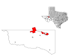
Ward County is a county located in the U.S. state of Texas. As of the 2020 census, its population was 11,644. The county seat is Monahans. The county was created in 1887 and organized in 1892. It is named for Thomas W. Ward, a soldier in the Texas Revolution.

<span class="mw-page-title-main">Upton County, Texas</span> County in Texas, United States

Upton County is a county located on the Edwards Plateau in the U.S. state of Texas. As of the 2020 census, its population was 3,308. Its county seat is Rankin. The county was created in 1887 and later organized in 1910. It is named for two brothers: John C. and William F. Upton, both colonels in the Confederate Army.

<span class="mw-page-title-main">Ector County, Texas</span> County in Texas, United States

Ector County is a county located in the U.S. state of Texas. In the 2020 census, its population was 165,171. Its county seat is Odessa. The county was founded in 1887 and organized in 1891. It is named for Mathew Ector, a Confederate general in the American Civil War.

<span class="mw-page-title-main">Crane County, Texas</span> County in Texas, United States

Crane County is a county located in the U.S. state of Texas. As of the 2020 census, its population was 4,675. The county seat is Crane. The county was created in 1887 and later organized in 1927. It was named for William Carey Crane, a president of Southern Baptist-affiliated Baylor University in Waco, Texas.

<span class="mw-page-title-main">Andrews County, Texas</span> County in Texas, United States

Andrews County is a county in the U.S. state of Texas. It is in West Texas and its county seat is Andrews.

<span class="mw-page-title-main">Seymour, Texas</span> City in Texas, United States

Seymour is a city in and the county seat of Baylor County, Texas, United States. Its population was 2,575 as of the 2020 Census.

<span class="mw-page-title-main">Robert Lee, Texas</span> City in Texas, United States

Robert Lee is a city in and the county seat of Coke County, Texas, United States. The population was 1,049 at the 2010 census.

<span class="mw-page-title-main">Crane, Texas</span> City in Texas, United States

Crane is a city in and the county seat of Crane County, Texas, United States. Its population is about 3,680 as of 2018. An oil boomtown since the 1920s, Crane is still in the center of a prominent oil-producing region. It is the only significant town in sparsely populated Crane County, and contains the only post office in the county.

<span class="mw-page-title-main">West Odessa, Texas</span> Census-designated place in Texas, United States

West Odessa is an unincorporated area and census-designated place (CDP) in Ector County, Texas, United States, on the west side of the city of Odessa. The population was 22,707 at the 2010 census, up from 17,799 at the 2000 census. It is part of the Odessa metropolitan area.

<span class="mw-page-title-main">Fairfield, Texas</span> City in Texas, United States

Fairfield is a city in Freestone County, Texas, United States. The population was 2,850 at the 2020 census, down from 3,094 at the 2000 census. It is the county seat of Freestone County and was founded as such in 1851.

<span class="mw-page-title-main">Haskell, Texas</span> City in Texas, United States

Haskell is a city in central Haskell County, Texas, United States. As of the 2010 census, the city population was 3,322. It is the Haskell county seat.

<span class="mw-page-title-main">Mertzon, Texas</span> City in Texas, United States

Mertzon is a city in and the county seat of Irion County, Texas, United States. Its population was 781 according to the 2010 census. It is part of the San Angelo, Texas, metropolitan statistical area.

<span class="mw-page-title-main">Pyote, Texas</span> Town in Texas, United States

Pyote is a town in Ward County, Texas, United States. Its population was 114 at the 2010 census.

<span class="mw-page-title-main">Thorntonville, Texas</span> Town in Texas, United States

Thorntonville is a town in Ward County, Texas, United States. The population was 476 according to the 2010 census.

<span class="mw-page-title-main">Wickett, Texas</span> Town in Texas, United States

Wickett is a town in Ward County, Texas, United States. The population was 498 at the 2010 census.

<span class="mw-page-title-main">Kermit, Texas</span> City in Texas, United States

Kermit is a city in and the county seat of Winkler County, Texas, United States. The population was 5,708 at the 2010 census. The city was named after Kermit Roosevelt following a visit by his father, President Theodore Roosevelt, to the county.

<span class="mw-page-title-main">Wink, Texas</span> City in Texas, United States

Wink is a city in Winkler County, Texas, United States. The population was 940 at the 2010 census. Wink was a temporary childhood home to singer and songwriter Roy Orbison, although he was born in Vernon, Texas. Orbison later described the major components of life in Wink as "football, oil fields, oil, grease and sand", and in later years expressed relief that he was able to leave the desolate town.

<span class="mw-page-title-main">Odessa, Texas</span> City in Texas

Odessa is a city in and the county seat of Ector County, Texas, United States. It is located primarily in Ector County, although a small section of the city extends into Midland County.

Southwest Sandhill is an unincorprated area and census-designated place (CDP) in Ward County, Texas, United States. It was first listed as a CDP prior to the 2020 census.

References

  1. "2019 U.S. Gazetteer Files". United States Census Bureau. Retrieved August 7, 2020.
  2. 1 2 "Population and Housing Unit Estimates". United States Census Bureau. May 24, 2020. Retrieved May 27, 2020.
  3. 1 2 "U.S. Census website". United States Census Bureau. Retrieved January 31, 2008.
  4. "US Board on Geographic Names". United States Geological Survey. October 25, 2007. Retrieved January 31, 2008.
  5. "Find a County". National Association of Counties. Retrieved June 7, 2011.
  6. "Record Heat Scorches Texas". ABC News .
  7. "NOWData - NOAA Online Weather Data". National Oceanic and Atmospheric Administration . Retrieved May 6, 2013.
  8. Texasalmanac (PDF-Datei; 1,13 MB). Retrieved 2013-08-01
  9. U.S. Census Archived 2013-07-08 at the Wayback Machine . Retrieved 2013-08-01
  10. "Explore Census Data". data.census.gov. Retrieved May 19, 2022.
  11. https://www.census.gov/ [ not specific enough to verify ]
  12. "About the Hispanic Population and its Origin". www.census.gov. Retrieved May 18, 2022.
  13. Daniel DeMay (December 17, 2015). "The most liberal and most conservative cities in the US". The Connecticut Post . Bridgeport, Connecticut . Retrieved December 20, 2015.
  14. "DIRECTORY - REGIONAL AND DISTRICT PAROLE OFFICES REGION V Archived 2010-01-25 at the Wayback Machine ." Texas Department of Criminal Justice. Retrieved on July 28, 2010.
  15. "Post Office Location - MONAHANS Archived 2011-07-16 at the Wayback Machine ." United States Postal Service. Retrieved on July 28, 2010.
  16. "Sec. 130.193. ODESSA COLLEGE DISTRICT SERVICE AREA".
  1. Note: the US Census treats Hispanic/Latino as an ethnic category. This table excludes Latinos from the racial categories and assigns them to a separate category. Hispanics/Latinos can be of any race. [11] [12]