
Kelling Heath is an 89.4-hectare (221-acre) biological Site of Special Scientific Interest between Holt and Weybourne in Norfolk. It is in the Norfolk Coast Area of Outstanding Natural Beauty.

Bilsey Hill is a 3-hectare (7.4-acre) geological Site of Special Scientific Interest south of Blakeney in Norfolk. It is a Geological Conservation Review site and it is in the Norfolk Coast Area of Outstanding Natural Beauty.

Dersingham Bog is a 159.1-hectare (393-acre) biological and geological Site of Special Scientific Interest in Norfolk, England. It is a Nature Conservation Review site, Grade 2, a National Nature Reserve and a Ramsar site It is part of the Norfolk Coast Area of Outstanding Natural Beauty, and the Roydon Common & Dersingham Bog Special Area of Conservation Part of it is a Geological Conservation Review site.
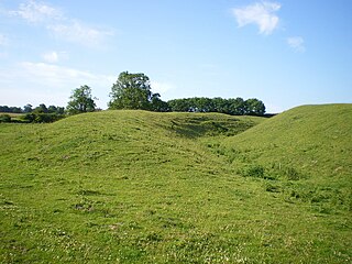
Warham Camp is an Iron Age circular hill fort with a diameter of 212 metres near Warham, south of Wells-next-the-Sea in Norfolk. It is a Scheduled Monument and a 5.1-hectare (13-acre) biological Site of Special Scientific Interest. It is in the Norfolk Coast Area of Outstanding Natural Beauty.

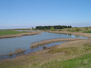
Salthouse Marshes is a 66-hectare (160-acre) nature reserve west of Sheringham in Norfolk. It is managed by the Norfolk Wildlife Trust. It is part of the North Norfolk Coast Site of Special Scientific Interest, Geological Conservation Review site, Nature Conservation Review site, Grade I. Ramsar site, Special Areas of Conservation and Special Protection Area. It is also in the Norfolk Coast Area of Outstanding Natural Beauty.
Holme Dunes is a 192-hectare (470-acre) nature reserve near Holme-next-the-Sea in Norfolk. It is managed by the Norfolk Wildlife Trust, and is a National Nature Reserve. It is part of the North Norfolk Coast Site of Special Scientific Interest, Geological Conservation Review site, Nature Conservation Review site, Grade I, Ramsar site, Special Areas of Conservation and Special Protection Area. It is also in the Norfolk Coast Area of Outstanding Natural Beauty.

Ringstead Downs is a 6.9-hectare (17-acre) biological Site of Special Scientific Interest east of Hunstanton in Norfolk. It is in the Norfolk Coast Area of Outstanding Natural Beauty, and it is the western part of the 11-hectare (27-acre) Ringstead Downs nature reserve, which is managed by the Norfolk Wildlife Trust.

Holkham Brick Pit is a 0.5-hectare (1.2-acre) geological Site of Special Scientific Interest west of Wells-next-the-Sea in Norfolk. It is a Geological Conservation Review site, and it is in the Norfolk Coast Area of Outstanding Natural Beauty.

Morston Cliff is a 1-hectare (2.5-acre) geological Site of Special Scientific Interest east of Wells-next-the-Sea in Norfolk. It is a Geological Conservation Review site. It is part of Blakeney National Nature Reserve, which is managed by the National Trust, and of the Norfolk Coast Area of Outstanding Natural Beauty.

Stiffkey Valley is a 44.4-hectare (110-acre) biological Site of Special Scientific Interest east of Wells-next-the-Sea in Norfolk. It is in the Norfolk Coast Area of Outstanding Natural Beauty.

Wells Chalk Pit is a 4-hectare (9.9-acre) biological and geological Site of Special Scientific Interest on the eastern outskirts of Wells-next-the-Sea in Norfolk. It is a Geological Conservation Review site, and it is in the Norfolk Coast Area of Outstanding Natural Beauty.
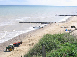
Mundesley Cliffs is a 29.3-hectare (72-acre) geological Site of Special Scientific Interest north-east of North Walsham in Norfolk. It is a Geological Conservation Review site and it is in the Norfolk Coast Area of Outstanding Natural Beauty.

Sheringham and Beeston Regis Commons is a 24.9-hectare (62-acre) biological Site of Special Scientific Interest in Sheringham in Norfolk. It is a Nature Conservation Review site, and part of the Norfolk Valley Fens Special Area of Conservation. and Norfolk Coast Area of Outstanding Natural Beauty.

Sidestrand and Trimingham Cliffs is a 133.9-hectare (331-acre) biological and geological Site of Special Scientific Interest south-east of Cromer in Norfolk. It is a Geological Conservation Review site. It is in the Norfolk Coast Area of Outstanding Natural Beauty.

Snettisham Carstone Quarry is an 11-hectare (27-acre) biological Site of Special Scientific Interest north of King's Lynn in Norfolk. It is in the Norfolk Coast Area of Outstanding Natural Beauty.

Winterton-Horsey Dunes is a 427-hectare (1,060-acre) biological and geological Site of Special Scientific Interest north of Great Yarmouth in Norfolk. It is a Special Area of Conservation and a Nature Conservation Review site, Grade I. Winterton Dunes is a National Nature Reserve Winterton Ness is a Geological Conservation Review site. The whole site is in the Norfolk Coast Area of Outstanding Natural Beauty.

Briton's Lane Gravel Pit is a 21.5-hectare (53-acre) geological Site of Special Scientific Interest east of Sheringham in Norfolk. It is a Geological Conservation Review site and it is in the Norfolk Coast Area of Outstanding Natural Beauty.

Glandford (Hurdle Lane) is a 9.4-hectare (23-acre) geological Site of Special Scientific Interest west of Sheringham in Norfolk. It is a Geological Conservation Review site and it is in the Norfolk Coast Area of Outstanding Natural Beauty.
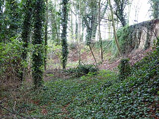
Weybourne Town Pit is a 0.7-hectare (1.7-acre) geological Site of Special Scientific Interest west of Sheringham in Norfolk. It is a Geological Conservation Review site and it is in the Norfolk Coast Area of Outstanding Natural Beauty.
