
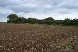
Swanscombe Skull Site or Swanscombe Heritage Park is a 3.9-hectare (9.6-acre) geological Site of Special Scientific Interest in Swanscombe, north-west Kent, England. It contains two Geological Conservation Review sites and a National Nature Reserve. The park lies in a former gravel quarry, Barnfield Pit, which is the most important site in the Swanscombe complex, alongside several other nearby pits.

Brimpton Pit is a 1.6-hectare (4.0-acre) geological Site of Special Scientific Interest west of Aldermaston in Berkshire. It is a Geological Conservation Review site.

Upper Common Pits is a 3-hectare (7.4-acre) geological Site of Special Scientific Interest in the north of Gomshall in Surrey. It is a Geological Conservation Review site.

Little Heath Pit is a 0.3-hectare (0.74-acre) geological Site of Special Scientific Interest at Little Heath near Potten End in Hertfordshire. It is part of the Ashridge Estate, owned by the National Trust, and the local planning authority is Dacorum Borough Council. It is listed in the Geological Conservation Review.

Fern House Gravel Pit is a 1.3-hectare (3.2-acre) geological Site of Special Scientific Interest in Fern, near Bourne End in Buckinghamshire. It is also a Geological Conservation Review site.
Eye Gravel Pit is a 0.4-hectare (0.99-acre) geological Site of Special Scientific Interest in Eye Green in Cambridgeshire. It is a Geological Conservation Review site, and part of it overlaps Eye Green Local Nature Reserve.

Holton Pit is a 1.6-hectare (4.0-acre) geological Site of Special Scientific Interest east of Halesworth in Suffolk. It is a Geological Conservation Review site.

Chillesford Church Pit is a 1.1-hectare (2.7-acre) geological Site of Special Scientific Interest in Chillesford, south of Saxmundham in Suffolk. It is a Geological Conservation Review site, and it is in the Suffolk Coast and Heaths Area of Outstanding Natural Beauty.

Neutral Farm Pit, Butley is a 1.1-hectare (2.7-acre) geological Site of Special Scientific Interest in Butley, east of Woodbridge in Suffolk. It is a Geological Conservation Review site, and is in the Suffolk Coast and Heaths Area of Outstanding Natural Beauty.

Valley Farm Pit, Sudbourne is a 0.5-hectare (1.2-acre) geological Site of Special Scientific Interest north of Orford in Suffolk. It is a Geological Conservation Review site, and in the Suffolk Coast and Heaths Area of Outstanding Natural Beauty.

Bawdsey Cliff is a 17.4-hectare (43-acre) geological Site of Special Scientific Interest north-east of Felixstowe in Suffolk. It is a Geological Conservation Review site, and is in the Suffolk Coast and Heaths Area of Outstanding Natural Beauty.

Aldeburgh Brick Pit is a 0.9-hectare (2.2-acre) geological Site of Special Scientific Interest in Aldeburgh in Suffolk. It is a Geological Conservation Review site, and it is in the Suffolk Coast and Heaths Area of Outstanding Natural Beauty.

Waldringfield Pit is a 0.8-hectare (2.0-acre) geological Site of Special Scientific Interest between Martlesham Heath and Waldringfield in Suffolk. It is a Geological Conservation Review site.

Sturry Pit is a 0.7 hectares geological Site of Special Scientific Interest north-east of Canterbury in Kent. It is a Geological Conservation Review site.
Heacham Brick Pit is a 0.8-hectare (2.0-acre) geological Site of Special Scientific Interest in Heacham, north of King's Lynn in Norfolk, England. It is a Geological Conservation Review site.

Sidestrand and Trimingham Cliffs is a 133.9-hectare (331-acre) biological and geological Site of Special Scientific Interest south-east of Cromer in Norfolk, England. It is a Geological Conservation Review site. It is in the Norfolk Coast Area of Outstanding Natural Beauty.

Wretton SSSI is a 20.6-hectare (51-acre) geological Site of Special Scientific Interest north-east of Downham Market in Norfolk, England. It is a Geological Conservation Review site.

Broome Heath Pit is a 1.2-hectare (3.0-acre) geological Site of Special Scientific Interest east of Ditchingham in Norfolk, England. It is a Geological Conservation Review site and part of Broome Heath Local Nature Reserve
Weybourne Town Pit is a 0.7-hectare (1.7-acre) geological Site of Special Scientific Interest west of Sheringham in Norfolk, England. It is a Geological Conservation Review site and it is in the Norfolk Coast Area of Outstanding Natural Beauty.
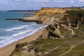
Highcliffe to Milford Cliffs is a 110.1-hectare (272-acre) geological Site of Special Scientific Interest which stretches along the south coast of England from Christchurch in Dorset to Milford on Seain Hampshire. It includes several Geological Conservation Review sites.
