
The Norfolk Wildlife Trust (NWT) is one of 46 wildlife trusts covering Great Britain, Northern Ireland, Isle of Man and Alderney. Founded in 1926, it is the oldest of all the trusts. It has over 35,500 members and eight local groups and it manages more than fifty nature reserves and other protected sites. It also gives conservation advice to individuals and organisations, provides educational services to young people on field trips and organises entertainment and information events at nature reserves. The NWT reserves include twenty-six Sites of Special Scientific Interests, nine national nature reserves, twelve Nature Conservation Review sites, sixteen Special Areas of Conservation, twelve Special Protection Areas, eleven Ramsar sites, two local nature reserves, four Geological Conservation Review sites and five which are in Areas of Outstanding Natural Beauty.

Alderfen Broad is a 21.3-hectare (53-acre) biological Site of Special Scientific Interest north-east of Norwich in Norfolk. It is managed by the Norfolk Wildlife Trust. It is part of the Broadland Ramsar site and Special Protection Area and The Broads Special Area of Conservation,

Hickling Broad is a 600-hectare (1,500-acre) nature reserve 4 km south-east of Stalham, north-east of Norwich in Norfolk. It is managed by the Norfolk Wildlife Trust. It is a National Nature Reserve and part of the Upper Thurne Broads and Marshes Site of Special Scientific Interest and Hickling Broad and Horsey Mere Nature Conservation Review site, Grade I. It is in the Norfolk Coast Area of Outstanding Natural Beauty, and part of the Broadland Ramsar site and Special Protection Area, and The Broads Special Area of Conservation.

Breydon Water is a 514.4-hectare (1,271-acre) biological Site of Special Scientific Interest at Great Yarmouth, Norfolk. It is a Local Nature Reserve, a Ramsar site and a Special Protection Area. It is part of the Berney Marshes and Breydon Water nature reserve, which is managed by the Royal Society for the Protection of Birds (RSPB).

Martham Broad is a 60-hectare (150-acre) national nature reserve north of Great Yarmouth in Norfolk. It is managed by the Norfolk Wildlife Trust, and is part of the Upper Thurne Broads and Marshes Site of Special Scientific Interest. It is also part of the Broadland Ramsar site and Special Protection Area, and The Broads Special Area of Conservation.
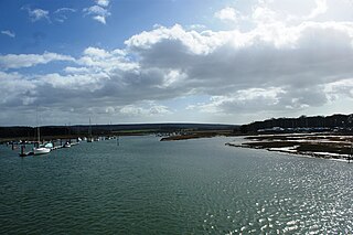
The River Yar on the Isle of Wight, England, rises near the beach at Freshwater Bay, on the south coast, and flows only a few miles north to Yarmouth where it meets the Solent. Most of the river is a tidal estuary. Its headwaters have been truncated by erosion of the south coast.

Hardley Flood is a 49.8-hectare (123-acre) biological Site of Special Scientific Interest near Loddon, between Norwich, Lowestoft and Great Yarmouth in Norfolk. It is part of the Broadland Ramsar site and Special Protection Area, and The Broads Special Area of Conservation.

Wangford Warren and Carr is a 67.8-hectare (168-acre) biological Site of Special Scientific Interest between Brandon and Lakenheath in Suffolk. It is a Nature Conservation Review site, Grade I, and part of the Breckland Special Area of Conservation, and Special Protection Area An area of 15 hectares is managed as a nature reserve by the Suffolk Wildlife Trust

Sutton and Hollesley Heaths is a 483.3-hectare (1,194-acre) biological Site of Special Scientific Interest south-east of Woodbridge in Suffolk. Most of the site is managed by the Suffolk Wildlife Trust as Sutton and Hollesley Commons. It is part of the Sandlings Special Protection Area under the European Union Directive on the Conservation of Wild Birds, and the Suffolk Coast and Heaths Area of Outstanding Natural Beauty.
Holme Dunes is a 192-hectare (470-acre) nature reserve near Holme-next-the-Sea in Norfolk. It is managed by the Norfolk Wildlife Trust, and is a National Nature Reserve. It is part of the North Norfolk Coast Site of Special Scientific Interest, Geological Conservation Review site, Nature Conservation Review site, Grade I, Ramsar site, Special Areas of Conservation and Special Protection Area. It is also in the Norfolk Coast Area of Outstanding Natural Beauty.

Tunstall Common is a 36.6 hectares biological Site of Special Scientific Interest east of Tunstall in Suffolk. It is part of the Sandlings Special Protection Area under the European Union Directive on the Conservation of Wild Birds, and the Suffolk Coast and Heaths Area of Outstanding Natural Beauty.

Bridgham and Brettenham Heaths is a 439.9-hectare (1,087-acre) biological Site of Special Scientific Interest north-east of Thetford in Norfolk, England. It is a Nature Conservation Review site, Grade I, and part of the Breckland Special Area of Conservation and Special Protection Area. Brettenham Heath is a National Nature Reserve.

Damgate Marshes, Acle is a 64.7-hectare (160-acre) biological Site of Special Scientific Interest between Norwich and Great Yarmouth in Norfolk. It is part of the Broadland Ramsar site and The Broads Special Area of Conservation.
Priory Meadows, Hickling is a 23.9-hectare (59-acre) biological Site of Special Scientific Interest south-east of North Walsham in Norfolk. It is part of the Broadland Ramsar site and Special Protection Area, and The Broads Special Area of Conservation.

Thetford Golf Course and Marsh is a 122.3-hectare (302-acre) biological Site of Special Scientific Interest on the western outskirts of Thetford in Norfolk. It is a Nature Conservation Review site, Grade 2, and part of the Breckland Special Area of Conservation and Special Protection Area.
Upper Thurne Broads and Marshes is a 1,185.9-hectare (2,930-acre) biological Site of Special Scientific Interest north of Great Yarmouth in Norfolk. Part of it is a Nature Conservation Review site, Grade I, and it is in the Norfolk Coast Area of Outstanding Natural Beauty. It is part of the Broadland Ramsar site and Special Protection Area, and The Broads Special Area of Conservation. Two areas, Hickling Broad and Martham Broad, are national nature reserves managed by the Norfolk Wildlife Trust.

Winterton-Horsey Dunes is a 427-hectare (1,060-acre) biological and geological Site of Special Scientific Interest north of Great Yarmouth in Norfolk. It is a Special Area of Conservation and a Nature Conservation Review site, Grade I. Winterton Dunes is a National Nature Reserve Winterton Ness is a Geological Conservation Review site. The whole site is in the Norfolk Coast Area of Outstanding Natural Beauty.
Crostwick Marsh is an 11.6-hectare (29-acre) biological Site of Special Scientific Interest in Crostwick, north of Norwich in Norfolk. It is part of the Broadland Ramsar site and Special Protection Area, and The Broads Special Area of Conservation.
