
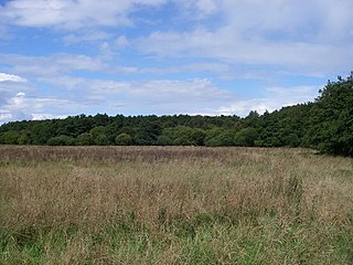
Breckland in Norfolk and Suffolk is a 39,433 hectare Special Protection Area (SPA) under the European Union Directive on the Conservation of Wild Birds. The SPA partly overlaps the 7,544 hectare Breckland Special Area of Conservation. As a landscape region it is an unusual natural habitat of England. It comprises the gorse-covered sandy heath that lies mostly in the south of the county of Norfolk but also in the north of Suffolk. An area of considerable interest for its unusual flora and fauna, it lies to the east of another unusual habitat, the Fens, and to the south west of the Broads. The typical tree of this area is the Scots pine. Breckland is one of the driest areas in England.

Great Eastern Pingo Trail is 9.2 kilometres long footpath along a disused railway line north of Thetford in Norfolk. It is a 4.2-hectare (10-acre) Local Nature Reserve, and it crosses three Sites of Special Scientific Interest, Thompson Water, Carr and Common, Breckland Forest and Cranberry Rough, Hockham. It also crosses Thompson Common, which is a nature reserve managed by the Norfolk Wildlife Trust and is a Nature Conservation Review site, Grade I. It further crosses Norfolk Valley Fens Special Area of Conservation and Breckland Special Protection Area.

Foxhole Heath is an 85.2-hectare (211-acre) biological Site of Special Scientific Interest east of Eriswell in Suffolk. It is a Nature Conservation Review site, Grade I, and part of Breckland Special Area of Conservation and Breckland Special Protection Area under the European Union Directive on the Conservation of Wild Birds.

Wangford Warren and Carr is a 67.8-hectare (168-acre) biological Site of Special Scientific Interest between Brandon and Lakenheath in Suffolk. It is a Nature Conservation Review site, Grade I, and part of the Breckland Special Area of Conservation, and Special Protection Area An area of 15 hectares is managed as a nature reserve by the Suffolk Wildlife Trust

East Wretham Heath is a 141.1-hectare (349-acre) biological Site of Special Scientific Interest south-east of Thetford in Norfolk, England. It is a Nature Conservation Review site, Grade I, and it is managed by the Norfolk Wildlife Trust. it is part of the Breckland Special Area of Conservation and Special Protection Area.

Weeting Heath is a 141.8-hectare (350-acre) biological Site of Special Scientific Interest west of Thetford in Norfolk, England, which is managed by the Norfolk Wildlife Trust. It is a Nature Conservation Review site, Grade I, and a National Nature Reserve. It is also part of the Breckland Special Area of Conservation and Special Protection Area.

Barnham Heath is a 78.6-hectare (194-acre) biological Site of Special Scientific Interest near Barnham, a village south of Thetford in Suffolk. It is a Nature Conservation Review site, Grade 2, and part of the Breckland Special Protection Area under the European Union Directive on the Conservation of Wild Birds

Cavenham–Icklingham Heaths is a 419 hectare biological Site of Special Scientific Interest west of Icklingham in Suffolk. It is a Nature Conservation Review site, Grade I, and part of Breckland Special Area of Conservation and Breckland Special Protection Area under the European Union Directive on the Conservation of Wild Birds. Cavenham Heath is a 203.1 hectare National Nature Reserve.

Deadman's Grave, Icklingham is a 127.3-hectare (315-acre) biological Site of Special Scientific Interest north-east of Icklingham in Suffolk. It is a Nature Conservation Review site, Grade I, and part of Breckland Special Area of Conservation and Breckland Special Protection Area under the European Union Directive on the Conservation of Wild Birds.

Little Heath, Barnham lies south-west of Barnham, Suffolk. Much of the area is now a Site of Special Scientific Interest, which almost surrounds the former chemical weapon store and filling station (FFD1)

Eriswell Low Warren is a 7.4-hectare (18-acre) biological Site of Special Scientific Interest north-east of Eriswell in Suffolk. It is a Nature Conservation Review site, Grade I, and part of the Breckland Special Protection Area under the European Union Directive on the Conservation of Wild Birds.

Thetford Heaths is a 270.6-hectare (669-acre) biological and geological Site of Special Scientific Interest in Suffolk. It is a Nature Conservation Review site, Grade I, and parts of it are a national nature reserve, and a Geological Conservation Review, It is part of the Breckland Special Area of Conservation, and Special Protection Area A large part of this dry heathland site is calcareous grassland, and some areas are grazed by sheep or rabbits. There are several nationally rare plants and an uncommon heathland bird, and many lichens and mosses.

Weather and Horn Heaths, Eriswell is a 133.3-hectare (329-acre) biological Site of Special Scientific Interest east of Eriswell in Suffolk. It is a Nature Conservation Review site, Grade I, and part of the Breckland Special Area of Conservation, and Special Protection Area

Ant Broads and Marshes is a 745.3-hectare (1,842-acre) biological Site of Special Scientific Interest north-east of Norwich in Norfolk, England. Most of it is a Nature Conservation Review site, Grade 1, and it is part of the Broadland Ramsar and Special Protection Area, and The Broads Special Area of Conservation. Part of it is the Barton Broad nature reserve, which is managed by the Norfolk Wildlife Trust, and two areas are National Nature Reserves.

Barnham Cross Common is a 69.1-hectare (171-acre) biological Site of Special Scientific Interest on the southern outskirts of Thetford in Norfolk, England. It is owned by Thetford Town Council and is registered common land. It is also a Local Nature Reserve and a Nature Conservation Review site, Grade 1. It is part of the Breckland Special Area of Conservation and Special Protection Area.

Bridgham and Brettenham Heaths is a 439.9-hectare (1,087-acre) biological Site of Special Scientific Interest north-east of Thetford in Norfolk, England. It is a Nature Conservation Review site, Grade I, and part of the Breckland Special Area of Conservation and Special Protection Area. Brettenham Heath is a National Nature Reserve.
Cranberry Rough is an 81.1-hectare (200-acre) biological and geological Site of Special Scientific Interest in the parish of Hockham, east of Attleborough in Norfolk, England. It is a Nature Conservation Review site, Grade 2, and the Great Eastern Pingo Trail, which is a Local Nature Reserve, goes through the site. Part of it is a Geological Conservation Review site, and it is part of the Breckland Special Protection Area.
Cranwich Camp is a 13.1-hectare (32-acre) biological Site of Special Scientific Interest north-west of Thetford in Norfolk, England. It is part of the Breckland Special Area of Conservation and Special Protection Area.
Stanford Training Area SSSI is part of the British Army Stanford Training Area. It is a 4,678-hectare (11,560-acre) biological and geological Site of Special Scientific Interest north of Thetford in Norfolk, England. It is a Nature Conservation Review site and part of it is a Geological Conservation Review site. It is also part of the Breckland Special Area of Conservation and Special Protection Area.
