Hammondville, Alabama

Last updated

Hammondville, Alabama
HammondvilleAlFireDept.jpg
The Volunteer Fire Department in Hammondville, Alabama
Flag of Hammondville, Alabama.png
DeKalb County Alabama Incorporated and Unincorporated areas Hammondville Highlighted 0132896.svg
Location of Hammondville in DeKalb County, Alabama.
Coordinates: 34°34′10″N85°38′18″W / 34.56944°N 85.63833°W / 34.56944; -85.63833
Country United States
State Alabama
County DeKalb
Area
[1]
  Total4.86 sq mi (12.59 km2)
  Land4.85 sq mi (12.56 km2)
  Water0.01 sq mi (0.03 km2)
Elevation
[2]
1,007 ft (307 m)
Population
 (2020)
  Total425
  Density87.67/sq mi (33.85/km2)
Time zone UTC-6 (Central (CST))
  Summer (DST) UTC-5 (CDT)
ZIP code
35989
Area code 256
FIPS code 01-32896
GNIS feature ID2406640 [2]

Hammondville is a town in DeKalb County, Alabama, United States. It was incorporated in 1937. As of the 2010 census, the population of the town is 488.

Contents

Geography

Hammondville is located at 34°34′10″N85°38′18″W / 34.56944°N 85.63833°W / 34.56944; -85.63833 (34.569414, -85.638305). [3]

According to the U.S. Census Bureau, the town has a total area of 4.9 square miles (13 km2), all land.

Demographics

Historical population
CensusPop.Note
1940 93
1950 941.1%
1960 13442.6%
1970 22164.9%
1980 36967.0%
1990 42013.8%
2000 48615.7%
2010 4880.4%
2020 425−12.9%
U.S. Decennial Census [4]
2013 Estimate [5]

As of the 2010 census Hammondville had a population of 488. The racial and ethnic composition of the population was 88.3% non-Hispanic white, 0.8% black or African American, 0.2% Native American, 0.6% Asian, 5.1% from some other race, 3.3% from two or more races and 6.8% Hispanic or Latino or any race. [6]

As of the census [7] of 2000, there were 486 people, 193 households, and 150 families residing in the town. The population density was 99.0 inhabitants per square mile (38.2/km2). There were 216 housing units at an average density of 44.0 per square mile (17.0/km2). The racial makeup of the town was 95.27% White, 1.65% Black or African American, 0.21% Native American, 0.41% Asian, 0.62% from other races, and 1.85% from two or more races. 2.67% of the population were Hispanic or Latino of any race.

There were 193 households, out of which 34.7% had children under the age of 18 living with them, 62.7% were married couples living together, 10.9% had a female householder with no husband present, and 21.8% were non-families. 18.1% of all households were made up of individuals, and 9.3% had someone living alone who was 65 years of age or older. The average household size was 2.52 and the average family size was 2.83.

In the town, the population was spread out, with 25.7% under the age of 18, 6.4% from 18 to 24, 28.6% from 25 to 44, 25.5% from 45 to 64, and 13.8% who were 65 years of age or older. The median age was 39 years. For every 100 females, there were 98.4 males. For every 100 females age 18 and over, there were 92.0 males.

The median income for a household in the town was $33,056, and the median income for a family was $34,500. Males had a median income of $33,542 versus $17,045 for females. The per capita income for the town was $20,582. About 8.0% of families and 10.7% of the population were below the poverty line, including 14.2% of those under age 18 and 20.0% of those age 65 or over.

Related Research Articles

<span class="mw-page-title-main">Henagar, Alabama</span> City in Alabama, United States

Henagar is a city in DeKalb County, Alabama, United States. At the 2020 census, the population was 2,292.

<span class="mw-page-title-main">Sylvania, Alabama</span> Town in Alabama, United States

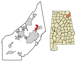
Sylvania is a town in DeKalb County, Alabama, United States. It incorporated in October 1967. At the 2010 census the population was 1,837, up from 1,186 in 2000. Sylvania is located atop Sand Mountain. Sylvania was incorporated in 1967. The post office /town hall was built in 1977.

<span class="mw-page-title-main">Greensboro, Florida</span> Town in the state of Florida, United States

Greensboro is a town in Gadsden County, Florida, United States. The Town of Greensboro is part of the Tallahassee Metropolitan Statistical Area. The population was 461 at the 2020 US census, down from 602 at the 2010 US census.

<span class="mw-page-title-main">Lyerly, Georgia</span> Town in Georgia, United States

Lyerly is a town in Chattooga County, Georgia, United States. As of the 2020 census, the town had a population of 454.

<span class="mw-page-title-main">Crystal Lawns, Illinois</span> Census designated place

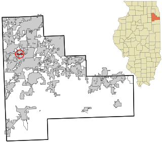
Crystal Lawns is a census-designated place (CDP) in Will County, Illinois, United States. The population was 1,830 at the 2020 census.

<span class="mw-page-title-main">Cassoday, Kansas</span> City in Butler County, Kansas

Cassoday is a city in Butler County, Kansas, United States. It is known as the "Prairie Chicken Capital of the World". As of the 2020 census, the population of the city was 113.

<span class="mw-page-title-main">Melvern, Kansas</span> City in Osage County, Kansas

Melvern is a city in Osage County, Kansas, United States, along the Marais des Cygnes River. As of the 2020 census, the population of the city was 356.

Princeton is a town in Washington County, Maine, United States. The town was named after Princeton, Massachusetts. The population was 745 at the 2020 census.

<span class="mw-page-title-main">Norwood Court, Missouri</span> Village in Missouri, United States

Norwood Court is a village in St. Louis County, Missouri, United States. The population was 959 at the 2010 census.

<span class="mw-page-title-main">Richland, New York</span> Town in New York, United States

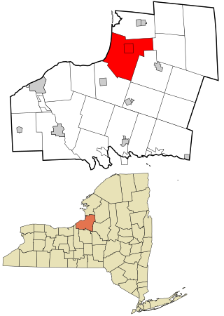
Richland is a town in the northeastern part of Oswego County, New York, United States. The population was 5,718 at the 2010 census.

<span class="mw-page-title-main">Economy, Pennsylvania</span> Borough in Pennsylvania, United States

Economy is a borough in Beaver County, Pennsylvania, United States. The population was 9,098 at the 2020 census. It is a part of the Pittsburgh metropolitan area.

<span class="mw-page-title-main">Midland, Pennsylvania</span> Borough in Pennsylvania, United States

Midland is a borough located along the Ohio River in western Beaver County, Pennsylvania, United States. As of the 2020 census, the population was 2,433. It is part of the Pittsburgh metropolitan area. Founded in 1906, it was initially a company town surrounding the Crucible Steel Company's Midland Works.

<span class="mw-page-title-main">Jonesville, South Carolina</span> City in South Carolina, United States

Jonesville is a town in Union County, South Carolina, United States. The population was 911 at the 2010 United States Census.

<span class="mw-page-title-main">Port Orchard, Washington</span> City in Washington, United States

Port Orchard is a city in and the county seat of Kitsap County, Washington, United States. It is located 13 miles (21 km) due west of West Seattle and is connected to Seattle and Vashon Island via the Washington State Ferries run to Southworth. It is named after Port Orchard, the strait that separates Bainbridge Island from the Kitsap Peninsula.

<span class="mw-page-title-main">Summitview, Washington</span> CDP in Washington, United States

Summitview is a census-designated place (CDP) in Yakima County, Washington, United States. The population was 967 at the 2010 census.

<span class="mw-page-title-main">La Farge, Wisconsin</span> Village in Wisconsin, United States

La Farge is a village along the Kickapoo River in Vernon County, Wisconsin, United States. Its population was 730 at the 2020 census.

<span class="mw-page-title-main">Holland (CDP), New York</span> Census-designated place in New York, United States

Holland is a hamlet and census-designated place (CDP) in Erie County, New York, United States. The population was 1,206 at the 2010 census. It is in the town of Holland and is part of the Buffalo–Niagara Falls Metropolitan Statistical Area.

<span class="mw-page-title-main">Westerly (CDP), Rhode Island</span> CDP in Rhode Island, United States

Westerly is a census-designated place (CDP) in the town of Westerly in Washington County, Rhode Island, United States. The population was 17,682 at the 2000 census. The CDP includes the majority of the town of Westerly's population, with only the rural eastern and coastal southern portions of towns excluded.

<span class="mw-page-title-main">Monroe (town), Green County, Wisconsin</span> Township in Wisconsin, United States

Monroe is a town in Green County, Wisconsin, United States. The population was 10,142 at the 2000 census. The City of Monroe is located partially within the town. The unincorporated community of Stearns is also located in the town.

Milford is a census-designated place (CDP) consisting of the main area of settlement within the town of Milford in Penobscot County, Maine, United States. The population was 2,233 at the 2010 census.

References

  1. "2020 U.S. Gazetteer Files". United States Census Bureau. Retrieved October 29, 2021.
  2. 1 2 U.S. Geological Survey Geographic Names Information System: Hammondville, Alabama
  3. "US Gazetteer files: 2010, 2000, and 1990". United States Census Bureau. February 12, 2011. Retrieved April 23, 2011.
  4. "U.S. Decennial Census". Census.gov. Retrieved June 6, 2013.
  5. "Annual Estimates of the Resident Population: April 1, 2010 to July 1, 2013". Archived from the original on May 22, 2014. Retrieved June 3, 2014.
  6. 2010 general profile of population and housing characteristics of Hammondville from the US census
  7. "U.S. Census website". United States Census Bureau . Retrieved January 31, 2008.

34°34′10″N85°38′18″W / 34.569414°N 85.638305°W / 34.569414; -85.638305