Hart's Location, New Hampshire

Last updated

Hart's Location, New Hampshire
Town
Harts Location US 302 March 2017.jpg
Looking north along U.S. Route 302 in Hart's Location
Carroll-Hart's-Location-NH.svg
Coordinates: 44°05′11″N71°21′07″W / 44.08639°N 71.35194°W / 44.08639; -71.35194
CountryUnited States
State New Hampshire
County Carroll
Incorporated 1795
Government
   Board of Selectmen
  • Mark R. Dindorf
  • Guy Putnam
  • John Gallagher
Area
[1]
  Total18.78 sq mi (48.65 km2)
  Land18.68 sq mi (48.38 km2)
  Water0.10 sq mi (0.27 km2)  0.56%
Elevation
897 ft (273 m)
Population
 (2020) [2]
  Total68
  Density4/sq mi (1.4/km2)
Time zone UTC−5 (Eastern)
  Summer (DST) UTC−4 (Eastern)
ZIP Code
03812
Area code 603
FIPS code 33-34500
GNIS feature ID0872015
Website www.hartslocation.com

Hart's Location is a town in Carroll County, New Hampshire, United States. Since 1948, the town has frequently been one of the first places to declare its results for the New Hampshire presidential primary and U.S. presidential elections. [3]

Contents

The population was 68 in the 2020 census. [2] It was incorporated in 1795. [4] Hart's Location maintains a board of selectmen, but is otherwise dependent on the town of Bartlett and Carroll County for services. Home to Crawford Notch State Park, which is noted for its rugged mountain beauty, the town is crossed by the Appalachian Trail.

History

Old Willey House (1793-1898) Old Willey House, Crawford Notch, NH.jpg
Old Willey House (1793–1898)

Hart's Location was named after Colonel John Hart of Portsmouth, New Hampshire. In 1772, the land was granted to Thomas Chadbourne, also of Portsmouth. [5] Native Americans used a trail up the Saco River valley through Crawford Notch, and during the French and Indian Wars, many English captives were taken to Canada that way. Despite this, the pass through the White Mountains was otherwise unknown until 1771, when Timothy Nash discovered it hunting moose, and told Governor John Wentworth. [6]

The obscure Indian trail transformed into the Coös Road, on which was built a small public house in 1793. It was abandoned, but in 1825 Samuel Willey Jr. occupied it with his wife, five children, and two hired hands. [7] During a violent storm on August 28, 1826, they all died in a landslide known as Willey's Slide. They fled their home and took refuge in a shelter, but it was destroyed while the house remained unscathed. [8]

A rock outcrop uphill divided the slide, which flowed around the home and reunited below it. The door was found gaping, a bible open on the table. Their tragedy inspired the short story "The Ambitious Guest" (1835) by Nathaniel Hawthorne, and Mount Willey was named in their memory. The house became part of a larger inn, then burned in 1898. Today, the location is a state historic site. [9]

In 1875, the Portland and Ogdensburg Railroad completed its line up through Crawford Notch. Passengers thrilled to traverse the Frankenstein Trestle, 520 feet (158 m) long and 85 feet (26 m) above the ravine floor, and then the Willey Brook Bridge, 400 feet (122 m) long and 94 feet (29 m) high. Later part of the Mountain Division of the Maine Central Railroad, the route is still traveled by the Conway Scenic Railroad. [10]

Geography

Frankenstein Cliff c. 1905 Frankenstein Cliff and Mt. Washington.jpg
Frankenstein Cliff c.1905

According to the United States Census Bureau, the town has a total area of 18.8 square miles (48.6 km2), of which 18.7 square miles (48.4 km2) are land and 0.1 square miles (0.3 km2), or 0.56%, are water. [1]

The shape of Hart's Location is unusual: about 11 miles (18 km) long and 1.5 miles (2.4 km) wide, with crooked boundaries that echo the confines of Crawford Notch, threaded by the upper Saco River and U.S. Route 302 near the centerline of the town, and pinched from both sides between steep mountains and in some areas sheer cliffs above. This anomaly is heightened on maps that show county lines: Coos County lies immediately to the east and Grafton County to the west, but Hart's Location is part of Carroll County, though barely connected to it.

The highest point in Hart's Location is 3,900 feet (1,200 m) above sea level along the town's western boundary, beneath the summit of 4,285-foot (1,306 m) Mount Willey. Arethusa Falls, New Hampshire's highest waterfall, located in the neighboring township of Livermore, is a popular hiking destination with access from U.S. Route 302 in Hart's Location. The town lies fully within the Saco River watershed. [11]

The town is a popular ice climbing destination in the winter months.

Demographics

Historical population
CensusPop.Note
1870 26
1880 70169.2%
1890 187167.1%
1900 38−79.7%
1910 85123.7%
1920 35−58.8%
1930 29−17.1%
1940 17−41.4%
1950 11−35.3%
1960 7−36.4%
1970 70.0%
1980 27285.7%
1990 3633.3%
2000 372.8%
2010 4110.8%
2020 6865.9%
U.S. Decennial Census [2] [12]

In the 2000 census, [13] there were 37 people, 15 households, and 10 families living there. The population density was 2.0 inhabitants per square mile (0.77/km2). There were 50 housing units at an average density of 2.7 per square mile (1.0/km2). The racial makeup of the location was 97.30% (36 people) White, with 2.70% (one person) citing themselves as from two or more races.

There were 15 households, out of which 33.3% had children under the age of 18 living with them, 66.7% were married couples living together, and 33.3% were non-families. 26.7% of all households were made up of individuals, and 6.7% had someone living alone who was 65 years of age or older. The average household size was 2.47 and the average family size was 3.10.

24.3% of residents were under the age of 18, 5.4% were from 18 to 24, 35.1% were from 25 to 44, 8.1% were from 45 to 64, and 27.0% were 65 years of age or older. The median age was 39 years. For every 100 females, there were 94.7 males. For every 100 females age 18 and over, there were 100.0 males.

The median household income was $41,250, and the median income for a family was $70,833. Males had a median income of $26,250 versus $28,750 for females. The per capita income for the town was $19,609. None of the population and none of the families were below the poverty line.

Politics

Federal elections

New Hampshire law allows towns with fewer than 100 residents to open the polls at midnight and close them as soon as all registered voters have cast their ballots. [14] Hart's Location is one of the New Hampshire communities where the first votes are cast in the Democratic and Republican New Hampshire primaries, the first presidential primaries in the United States during each presidential election year. The tradition of first-in-the-nation voting in Hart's Location dates back to 1948 when residents initially voted at 7 AM. In 1952, the town shifted to midnight to facilitate greater access to the polls for railroad workers. [15]

In 1964, Hart's Location discontinued the practice of midnight voting. In 1996 the tradition was revived, thanks to new owners of a local inn who aimed to garner more media attention for the small town. In 2024, it was announced that the town would once again abandon the practice. Local officials cited reasons such as the increasing length of ballots, the time required for vote tallying, and new stringent voting requirements that complicate the process. [15]

Election results

Boldfaced names indicate the ultimate nationwide winner of each contest:

1996
Dem. primary:
(12 votes)
Rep. primary:
(19 votes)
General election:
(31 votes)
Bill Clinton – 12 Lamar Alexander – 8 Bob Dole – 13
Bob Dole – 3 Bill Clinton – 12
Pat Buchanan – 3 Ross Perot – 4
Steve Forbes – 3 Harry Browne – 2
Phil Gramm – 1
Colin Powell – 1, write-in
2000
Dem primary:
(12 votes)
Rep primary:
(14 votes)
General election:
(30 votes)
Bill Bradley – 9 John McCain – 9 George W. Bush – 17
Al Gore – 3 George W. Bush – 5 Al Gore – 13
2004
Dem. primary:
(16 votes)
Rep. primary:
(13 votes)
General election:
(31 votes)
Wesley Clark – 6 George W. Bush – 13 George W. Bush – 16
John Kerry – 5 John Kerry – 14
Howard Dean – 3 Ralph Nader – 1
John Edwards – 2
2008
Dem. primary:
(13 votes) [14]
Rep. primary:
(16 votes) [14]
General election:
(29 votes) [16]
Barack Obama – 9 John McCain – 6 Barack Obama – 17
Hillary Clinton – 3 Mike Huckabee – 5 John McCain – 10
John Edwards – 1 Ron Paul – 4 Ron Paul – 2, write-in
Mitt Romney – 1
2012
Dem. primary:
[17]
Rep. primary:
(13 votes) [17]
General election:
(33 votes) [18]
Barack Obama – 10 Mitt Romney – 5 Barack Obama – 23
Ron Paul – 4 Mitt Romney – 9
Jon Huntsman – 2 Gary Johnson – 1
Newt Gingrich – 1
Rick Perry – 1
2016
Dem. primary:
(21 votes)
Rep. primary:
(14 votes)
General election:
(37 votes) [19]
Bernie Sanders – 12 John Kasich – 5 Hillary Clinton – 17
Hillary Clinton – 7 Donald Trump – 4 Donald Trump – 14
Mark Stewart Greenstein – 2 Chris Christie – 2 Gary Johnson – 3
Jeb Bush – 1 Bernie Sanders – 2
Ben Carson – 1 John Kasich/Sanders (write-in) – 1
Marco Rubio – 1
2020
Dem. primary:
(18 votes) [20]
Rep. primary:
(20 votes) [20]
General election:
(43 votes) [21]
Amy Klobuchar – 6 Donald Trump – 15 Joe Biden – 23
Elizabeth Warren – 4 Bill Weld – 4 Donald Trump – 20
Andrew Yang – 3Mary Maxwell – 1
Bernie Sanders – 2
Joe Biden – 1
Tulsi Gabbard – 1
Tom Steyer – 1

The community's voting tradition received a nod in the 2002 third-season episode of US television program The West Wing , in an episode entitled "Hartsfield's Landing", named after a town modeled on either Hart's Location, or its companion, Dixville Notch.

See also

Related Research Articles

<span class="mw-page-title-main">Coös County, New Hampshire</span> County in New Hampshire, United States

Coös County or Coos County is a county in the U.S. state of New Hampshire. As of the 2020 census, the population was 31,268, making it the least-populated county in the state. The county seat is Lancaster.

<span class="mw-page-title-main">Carroll County, New Hampshire</span> County in New Hampshire, United States

Carroll County is a county in the U.S. state of New Hampshire. As of the 2020 census, the population was 50,107, making it the third-least populous county in New Hampshire. Its county seat is Ossipee. The county was created in 1840 and organized at Ossipee from towns removed from Strafford County. It was named in honor of Charles Carroll of Carrollton, who had died in 1832, the last surviving signer of the United States Declaration of Independence.

<span class="mw-page-title-main">Albany, New Hampshire</span> Town in New Hampshire, United States

Albany is a town in Carroll County, New Hampshire, United States. The population was 759 at the 2020 census.

<span class="mw-page-title-main">Bartlett, New Hampshire</span> Town in New Hampshire, United States

Bartlett is a town in Carroll County, New Hampshire, United States. The population was 3,200 at the 2020 census, up from 2,788 at the 2010 census. Bartlett includes the unincorporated community of Glen as well as portions of the communities of Kearsarge and Intervale, which the town shares with the neighboring town of Conway. It is set in the White Mountains and is surrounded by the White Mountain National Forest. It is home to the Attitash Mountain Resort and the Story Land theme park.

<span class="mw-page-title-main">Chatham, New Hampshire</span> Town in New Hampshire, United States

Chatham is a town in Carroll County, New Hampshire, United States. The population was 341 at the 2020 census. It is located in the White Mountains, and except for the southeastern corner, all of Chatham is in the White Mountain National Forest. The town is home to the Cold River national forest campgrounds.

<span class="mw-page-title-main">Jackson, New Hampshire</span> Town in New Hampshire, United States

Jackson is a town in Carroll County, New Hampshire, United States. The population was 1,028 at the 2020 census, up from 816 at the 2010 census. Jackson is a resort area in the White Mountains. Parts of the White Mountain National Forest are in the west, north and east.

<span class="mw-page-title-main">Madison, New Hampshire</span> Town in New Hampshire, United States

Madison is a town in Carroll County, New Hampshire, United States. The population was 2,565 at the 2020 census. Madison includes the village of Silver Lake and the village district of Eidelweiss.

<span class="mw-page-title-main">Sandwich, New Hampshire</span> Town in New Hampshire, United States

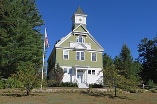
Sandwich is a town in Carroll County, New Hampshire, United States. Its population was 1,466 at the 2020 census. Sandwich includes the villages of Center Sandwich and North Sandwich. Part of the White Mountain National Forest is in the north, and part of Squam Lake is in the southwestern corner of the town. As such, Sandwich lies on the boundary between New Hampshire's Lakes Region and White Mountains Region. The Sandwich Range of the White Mountains lies partially within the town, as does the namesake Sandwich Mountain. The town is home to the Sandwich Fair, a popular agricultural fair that occurs every October.

<span class="mw-page-title-main">Carroll, New Hampshire</span> Town in New Hampshire, United States

Carroll is a town in Coös County, New Hampshire, United States. The population was 820 at the 2020 census. The two largest villages are Twin Mountain and Bretton Woods. Carroll is an important access point for recreational areas in the White Mountains, including many 4,000-footers, the Zealand River area, the Presidential Range, and the Presidential Dry River Wilderness. The town is home to the Mount Washington Hotel at Bretton Woods and to the Highland Center at Crawford Notch, the Appalachian Mountain Club's four-season lodge.

<span class="mw-page-title-main">Clarksville, New Hampshire</span> Town in New Hampshire, United States

Clarksville is a town in northern Coös County, New Hampshire, United States. The population was 294 at the 2020 census. It is part of the Berlin, NH-VT Micropolitan Statistical Area.

<span class="mw-page-title-main">Dixville, New Hampshire</span> Township in Coos County, New Hampshire, United States

Dixville is a township in Coös County, New Hampshire, United States. The population was 4 as of the 2020 census, down from 12 at the 2010 census. In New Hampshire, locations, grants, townships, and purchases are unincorporated portions of a county which are not part of any town and have limited self-government.

<span class="mw-page-title-main">Errol, New Hampshire</span> Town in New Hampshire, United States

Errol is a town in Coös County, New Hampshire, United States. The population was 298 at the 2020 census. It is located north of the White Mountains along Route 16 at its intersection of Route 26. It has a municipal airport with a single, unpaved runway.

<span class="mw-page-title-main">Wentworth Location, New Hampshire</span> Township in Coos County, New Hampshire, United States

Wentworth Location is a township in Coös County, New Hampshire, United States. Its population was 28 at the 2020 census. It is part of the Berlin, NH-VT Micropolitan Statistical Area.

<span class="mw-page-title-main">Conway, New Hampshire</span> Town in New Hampshire, United States

Conway is a town in Carroll County, New Hampshire, United States. It is the most populous community in the county, with a population of 9,822 at the 2020 census, down from 10,115 at the 2010 census. The town is on the southeastern edge of the White Mountain National Forest. There are five villages in the town: Conway, North Conway, Center Conway, Redstone and Kearsarge. Additionally, it shares a portion of the village of Intervale with the neighboring town of Bartlett.

<span class="mw-page-title-main">Dixville Notch, New Hampshire</span> Unincorporated community in New Hampshire, United States

Dixville Notch is an unincorporated community in Dixville township, Coos County, New Hampshire, United States. The population of the township, all of whom live in Dixville Notch, was 4 as of the 2020 census. The village is known for being the first place to declare its results during the New Hampshire presidential primary. It is located in the northern part of the state, approximately 20 miles (32 km) south of the border with the Canadian province of Quebec. The village is situated at about 1,800 feet (550 m) above sea level at the base of mountains.

<span class="mw-page-title-main">Crawford Notch</span> Major pass through White Mountains in New Hampshire, US

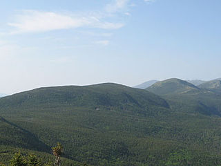
Crawford Notch is a major pass through the White Mountains of New Hampshire, located in Hart's Location. Roughly half of that town is contained in Crawford Notch State Park. The high point of the notch, at approximately 1,900 feet (580 m) above sea level, is at the southern end of the town of Carroll, near the Crawford Depot train station and Saco Lake, the source of the Saco River, which flows southward through the steep-sided notch. North of the high point of the notch, Crawford Brook flows more gently northwest to the Ammonoosuc River, a tributary of the Connecticut River.

<span class="mw-page-title-main">Bean's Grant, New Hampshire</span> Township in Coos County, New Hampshire, United States

Bean's Grant is a township in southern Coös County, New Hampshire, United States, north of Crawford Notch State Park. The grant lies entirely within the White Mountain National Forest. The population was zero as of the 2020 census.

<span class="mw-page-title-main">Millsfield, New Hampshire</span> Township in Coos County, New Hampshire, United States

Millsfield is a township in Coös County, New Hampshire, United States. It is part of the Berlin, NH-VT Micropolitan Statistical Area. The population was 25 at the 2020 census.

<span class="mw-page-title-main">Bartlett (CDP), New Hampshire</span> Census-designated place in New Hampshire, United States

Bartlett is a census-designated place (CDP) and the main village in the town of Bartlett in Carroll County, New Hampshire, United States. The population was 351 at the 2020 census, out of 3,200 in the entire town of Bartlett.

<span class="mw-page-title-main">New Hampshire midnight voting</span> American election tradition

In New Hampshire, United States, the communities of Dixville Notch, Hart's Location, and Millsfield all vote at the midnight beginning election day, known as the New Hampshire midnight votes, on the day of the state's political party primaries and general elections, following a tradition that started to accommodate railroad workers who had to be at work before normal voting hours. The voting tradition has been followed in Dixville Notch since the 1960 presidential election, in Hart's Location from 1948 to 1964 and from 1996 to 2020, and in Millsfield in 2016 and 2020.

References

  1. 1 2 "2021 U.S. Gazetteer Files – New Hampshire". United States Census Bureau. Retrieved November 1, 2021.
  2. 1 2 3 "Hart's Location town, Carroll County, New Hampshire: 2020 DEC Redistricting Data (PL 94-171)". U.S. Census Bureau. Retrieved November 1, 2021.
  3. Schworm, Peter (January 7, 2008). "N.H. towns vie for late-night voter limelight". The Boston Globe.
  4. "Hart's Location Town Services". Hart's Location official website. Retrieved November 17, 2016.
  5. "New Hampshire Economic and Labor Market Information Bureau Profile". nh.gov. Retrieved April 12, 2018.
  6. Austin J. Coolidge & John B. Mansfield, A History and Description of New England; Boston, Massachusetts 1859
  7. "RootsWeb.com Home Page". www.rootsweb.ancestry.com. Retrieved April 12, 2018.
  8. "New Hampshire Division of Parks & Recreation — Story of the Willey Family". nhstateparks.org. Retrieved April 12, 2018.
  9. "New Hampshire Division of Parks & Recreation — Story of the Willey Family". nhstateparks.org. Retrieved April 12, 2018.
  10. "Crawford Notch". whitemountainhistory.org. Retrieved April 12, 2018.
  11. Foster, Debra H.; Batorfalvy, Tatianna N.; Medalie, Laura (1995). Water Use in New Hampshire: An Activities Guide for Teachers. U.S. Department of the Interior and U.S. Geological Survey.
  12. "Census of Population and Housing". Census.gov. Retrieved June 4, 2016.
  13. "U.S. Census website". United States Census Bureau . Retrieved January 31, 2008.
  14. 1 2 3 Canfield, Clarke (January 8, 2008). "McCain, Obama, get early votes in N.H. villages". The Boston Globe. Associated Press. Archived from the original on November 2, 2008. Retrieved January 8, 2008.
  15. 1 2 "Hart's Location will skip midnight voting for 2024 presidential primary". New Hampshire Public Radio. January 4, 2024. Retrieved January 5, 2024.
  16. "Obama wins in early-voting towns". BBC Online . November 4, 2008. Retrieved May 20, 2023.
  17. 1 2 "Hart's Location, New Hampshire". hartslocation.com. Archived from the original on May 24, 2012 via Wayback Machine.
  18. "First Election Day voters, in two tiny N.H. locations, give Obama lead". CBS News. November 6, 2012.
  19. "2016 Election Results - Hart's Location". Town of Hart's Location. Retrieved November 8, 2016.
  20. 1 2 "First results of 2020 New Hampshire Primary are in after midnight voting". WMUR. February 11, 2020. Retrieved February 11, 2020.
  21. "2020 Election Results". Hart's Location. Retrieved January 5, 2021.