Heydon, Norfolk

Last updated

Heydon
St peter and St Paul's Church Heydon, Norfolk.JPG
St Peter and St Paul's church
Norfolk UK location map.svg
Red pog.svg
Heydon
Location within Norfolk
Area8.02 km2 (3.10 sq mi)
Population89 (2001 census [1] )
  Density 11/km2 (28/sq mi)
OS grid reference TG113273
Civil parish
  • Heydon
District
Shire county
Region
Country England
Sovereign state United Kingdom
Post town NORWICH
Postcode district NR11
Dialling code 01263
Police Norfolk
Fire Norfolk
Ambulance East of England
UK Parliament
List of places
UK
England
Norfolk
52°48′07″N1°08′02″E / 52.802°N 1.134°E / 52.802; 1.134

Heydon is a village and civil parish in Norfolk, England.

Contents

It is located 3 miles (4.8 km) north of the market town of Reepham. The village can be accessed by the public only from the south, resulting in the only road, called The Street, effectively being a cul-de-sac for general traffic. At its centre is a green, surrounded by the parish church and traditional English rural buildings.

The village is privately owned, by the Bulwer family. [2]

History

Medieval

The village is not referred to in the Domesday Book of 1086, and it is considered that it was at that time part of the manor of Stinton, a settlement long since depopulated, located in the neighbouring parish of Salle. [3]

The name is believed to derive from "high down" or similarly "plain on the hill". It is written in 1196 as Heidon. [4]

A market charter was granted in 1311. [4]

The 14th/15th century Church of St Peter and St Paul is a grade I listed building [5] and contains some notable wall paintings, rediscovered in 1970. [4]

Heydon Hall

Erasmus Earle, one of the most noted lawyers of his time, was lord of the manor in the early 17th century. The 19th century lord was William Earle Lytton Bulwer (1799–1877), elder brother of the author Edward Bulwer Lytton. [6] The village is still owned by the Bulwer Long family, one of only around a dozen English villages that are entirely privately owned. The Elizabethan Heydon Hall, built in 1582 by Henry Dynne and extended in the late 18th and early 19th century, [6] is at the head of the estate and is located just northeast of the village within the private Heydon Park.

Heydon Hall, a Grade I listed building, completed in 1584, was modified in the mid 1700s and restored in the late 1900s. As of 2021, it is the home of Rhona Bulwer Long and her family, who allow tourists to walk the grounds; the Estate Office occasionally agrees to open the Hall for filming and special events. [7] [8]

18th and 19th centuries

The green, church and well house Village green , Heydon - geograph.org.uk - 302163.jpg
The green, church and well house

By the village green there is an 18th-century public house – The Earle Arms – which is grade II listed [9] and has a "Regionally Important Historic Interior". [10] It was until circa 1845 called the Lion and Lamb. [11] It is believed that a pub has existed at this location since the 16th century, and was a coaching inn. The front elevation of the building features a wood sculpture of Mary Read, an 18th-century pirate, believed to originate from that century. [12]

There was a common, located to the northwest of the village, until enclosed into Heydon Park by the mid-19th century. The early 19th-century expansion of the Park also resulted in the closure to the public of the through-road, shown on the Tithe map (c. 1836–50) [13] that ran from the northwest at Corpusty Road, along/through the common, passing the parish church and Earle Arms coaching inn (along a stretch that remains a highway), then across/around the village green and then passing Heydon Grange and Park Farm to the southeast at Dog Corner; resulting in the village since being only accessible by public highway via the one road from the south.

The village had a school, built 1840-2 and closed in 1962; located on The Street, it has been converted to housing. [14] [15]

The area was served by the Bluestone railway station from 1883 to 1916; the line, now dismantled, ran through the northeast edge of the parish, roughly parallel to the B1149 road. Other nearby stations were at Cawston (closed 1952) and Corpusty (closed 1959). Also in 1883, the church acquired an organ, built by Wordsworth and Maskell, of Leeds, and donated by general Edward Bulwer in memory of his wife. Unusually for this period of English organ-building, the organ has a reversed console, in which the organist faces out into the church. It was restored in 2021-2022. [16]

The village retains an old-fashioned character with no new buildings having been added since the well house commemorating the Golden Jubilee of Queen Victoria was built in 1887. [17] The Jubilee Memorial Well House is an example of Tudor Revival architecture and is grade II listed. [18]

The population of the parish of Heydon increased from 296 in 1801 to a recorded peak of 350 in 1831. With the reduction in agricultural labour, and the draw of the working class to urban areas in Britain's industrial revolution, the population then fell to 205 in 1891. [19]

20th and 21st centuries

After a few decades (1890s-1930s) of a stable population in the low 200s, the population declined again in the mid- and late-20th century to just 89 in 2001. No parish-specific figure is available for the 2011 census, however the population is estimated in the 2010s to be around 100; barns to the rear of Cropton Hall were converted to houses in the late 2010s.

Heydon became Norfolk's first conservation area in 1971, having won the county's Best Kept Village in 1967 and 1968. This conservation area covers the village, [4] and in 1991 a further conservation area was designated which covers the wider landscape setting to the village, including a part of the neighbouring parish of Salle. [20]

The Parish Room is a World War I soldiers' accommodation hut which was re-sited to the village in 1922; it serves as the village hall and was restored in 2013. [21]

The village's blacksmith workshop closed in 2007. [22]

Since 1756, the village has been owned by the Bulwer family. As of 2021, Heydon has a population of about a hundred; businesses included "a pub, a tea room, bakery, floral design and artisan store, antiques shop, interiors and clothing studio, a beauty barn and hairdressers". [23] Heydon contains 45 cottages and houses which are rented to tenants. [24]

The village in 2020, with the car park and commercial area at the left-foreground, formerly Church Farm Heydon Norfolk 8 May 2020.png
The village in 2020, with the car park and commercial area at the left-foreground, formerly Church Farm

Filming location

Heydon has on several occasions been used in television and film productions. The village was used as the setting for the Anglia Television soap opera Weaver's Green . Films partly shot in the village or at the Hall include The Go Between (1970), Riders (1993), Hitler's Britain (2002), Vanity Fair, The Woman in White, The Moonstone (1996), The Peppermint Pig, and A Cock and Bull Story (2005). [17] [25] A Monty Python's Flying Circus sketch about village idiots was filmed here, [26] using several locations in the village including the former school. The Earle Arms was used as the "Winterman Arms" in the ITV sitcom Rising Up (1999). [11]

Geography

An entrance to Heydon Park, at Dog Corner, in the form of a gatehouse with lodges either side Dog Corner, Heydon - geograph.org.uk - 304304.jpg
An entrance to Heydon Park, at Dog Corner, in the form of a gatehouse with lodges either side

The civil parish consists of the village together with Heydon Hall and its parkland, and several outlying farms and houses including the grade II* listed Cropton Hall, dating from 1702. [27] The village is at an elevation of approximately 45 metres (148 ft) above sea level.

1.5 miles (2.4 km) to the south is the small village of Salle. The other neighbouring parishes are Thurning, Corpusty and Saxthorpe, Oulton, Cawston and Wood Dalling.

Governance

Due to its small population, the parish has a parish meeting rather than a parish council. [28]

The parish forms part of the ward of Eynesford, which elects a councillor on Broadland District Council. [28] Although Eynesford is named after a hundred, Heydon formed part of the neighbouring hundred of South Erpingham.

Amenities

As of 2020, at the centre of the village there is a traditional pub, a tea room, a bakery (operating from the former blacksmiths) and seven small retail/service businesses located in the buildings that have in recent years been converted from Church Farm. The village no longer has a post office or convenience shop. The church continues to be used for regular Christian worship [29] and the parish room is in frequent use.

Annual public events, held on the green and attracting visitors from beyond the parish, are the tug of war competition in May [30] and traditional Guy Fawkes Night (bonfire night) celebrations.

Notable people

Related Research Articles

<span class="mw-page-title-main">Broadland</span> Non-metropolitan district in England

Broadland is a local government district in Norfolk, England, named after the Norfolk Broads. Its council is based at the Broadland Business Park on the outskirts of Norwich. The district includes the towns of Aylsham, Reepham, Sprowston and Thorpe St Andrew. Several of the district's settlements form part of the Norwich built-up area, lying outside the city's boundaries to the north-west and north-east. The district also includes numerous villages and surrounding rural areas. Some eastern parts of the district lie within The Broads.

<span class="mw-page-title-main">Old Catton</span> Human settlement in England

Old Catton is a suburban village and civil parish in the English county of Norfolk which lies 2 miles (3.2 km) to the north-east of central Norwich. The parish is bounded by the Norwich International Airport at Hellesdon to the west and Sprowston to the east. The northern boundary is with the village of Spixworth while the A1042 road forms the southern boundary. It covers an area of 2.33 km2 (0.90 sq mi) and had a population of 5,954 in 2,512 households at the 2001 census, increasing to a population of 6,108 in 2,666 households at the 2011 Census. For the purposes of local government, it falls within the district of Broadland. The village is twinned with the French commune of Lavaré.

<span class="mw-page-title-main">New Buckenham</span> Human settlement in England

New Buckenham is a village and civil parish in the English county of Norfolk.

<span class="mw-page-title-main">Barton Bendish</span> Village and a civil parish in the English county of Norfolk

Barton Bendish is a civil parish and small ancient village in the English county of Norfolk located 10 miles (16 km) south of King's Lynn and 90 miles (140 km) North East of London. It has two medieval parish churches, and once had three. The parish includes the old hamlet of Eastmoor, and covers 3,936 acres (1,593 ha). The village has been settled since Neolithic times and was expanded during the Saxon period. Today the village has a population of 210 as recorded at the 2010 census and contains eight listed buildings, with the two medieval parishes churches being Grade I.

<span class="mw-page-title-main">Blickling</span> Human settlement in England

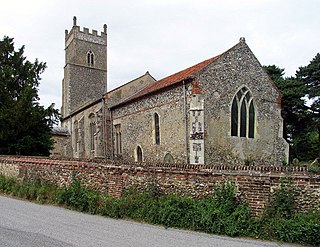
Blickling is a village and civil parish in the Broadland district of Norfolk, England, about 1.5 miles (2.4 km) north-west of Aylsham. In the 2011 census, it had a population of 113 and covered 862 hectares, before dropping to 110 residents as of the 2021 census. Since the 17th century the village has been concentrated in two areas, around the church and also at the park gates of Blickling Hall. Most of the village is contained in the Blickling Estate, which has been owned by the National Trust since 1940.

<span class="mw-page-title-main">Blundeston</span> Village in Suffolk, England

Blundeston is a village and civil parish in the north of the English county of Suffolk. It is 3.5 miles (5.6 km) north-west of Lowestoft, 6 miles (9.7 km) south of Great Yarmouth and around 1.75 miles (2.82 km) inland from the North Sea coast. It is part of the area known as Lothingland in the East Suffolk district. Blundeston Prison was located on the southern edge of the village but closed in early 2014.

<span class="mw-page-title-main">Salle, Norfolk</span> Village in Norfolk, England

Salle is a small village and civil parish in the Broadland district, in the county of Norfolk, England. 1.5 miles (2.4 km) to the south is the market town of Reepham.

<span class="mw-page-title-main">Burgh and Tuttington</span> Human settlement in England

Burgh and Tuttington is a civil parish in the English county of Norfolk. It covers an area of 6.70 km2 (2.59 sq mi) and had a population of 255 in 115 households at the 2001 census, increasing to a population of 322 in 140 households at the 2011 Census. For the purposes of local government, it falls within the district of Broadland. The parish includes Burgh next Aylsham and Tuttington.

<span class="mw-page-title-main">Ringstead, Norfolk</span> Human settlement in England

Ringstead is a village and civil parish in the north-west corner of the English county of Norfolk. It covers an area of 11.13 km2 (4.30 sq mi) and had a population of 355 in 155 households at the 2001 census, reducing to 324 at the 2011 census. For the purposes of local government, it falls within the district of King's Lynn and West Norfolk.

<span class="mw-page-title-main">Wood Dalling</span> Village in Norfolk, England

Wood Dalling is a village and civil parish in Norfolk, England. It is located 8 miles (13 km) south of Holt and 3 miles (4.8 km) north of Reepham, the nearest market towns.

<span class="mw-page-title-main">Saxlingham</span> Human settlement in England

Saxlingham is a village and former civil parish, now in the parish of Field Dalling, in the North Norfolk district, in the county of Norfolk, England. It lies 13 miles (21 km) west of Cromer, 26 miles (42 km) north-west of Norwich, 3.6 miles (5.8 km) west of the town of Holt and 126 miles (203 km) north-east of London. In 1931 the parish had a population of 122.

<span class="mw-page-title-main">Lamas, Norfolk</span> Human settlement in England

Lamas is a village in Broadland, Norfolk, England. Administratively it falls within the civil parish of Buxton with Lamas.

<span class="mw-page-title-main">Cropton</span> Village and civil parish in North Yorkshire, England

Cropton is a village and civil parish in the Ryedale district of North Yorkshire, England. It is on the border of the North York Moors National Park, 3 miles (5 km) north-west of Pickering.

<span class="mw-page-title-main">Brandiston</span> Human settlement in England

Brandiston is a small village and civil parish near the centre of the county of Norfolk, England, about two miles south-east of the small market town of Reepham, five miles south-west of the larger town of Aylsham and 10 miles north-west of the city of Norwich. For the purposes of local government, it falls within Broadland district. The hamlet of Guton lies within the parish.

<span class="mw-page-title-main">Hemblington</span> Human settlement in England

Hemblington is a civil parish in the English county of Norfolk, about 8 miles (13 km) east of Norwich. It covers an area of 3.03 km2 (1.17 sq mi) and had a population of 316 in 134 households at the 2001 census, increasing to a population of 332 in 146 households at the 2011 Census. For the purposes of local government, it falls within the district of Broadland. As well as the village of Hemblington the parish includes the hamlet of Pedham some 1+12 miles (2 km) to the northwest.

<span class="mw-page-title-main">Foxley</span> Human settlement in England

Foxley is a village and civil parish in Norfolk, England. The village is 6 miles (10 km) north-east of Dereham and 15 miles (24 km) north-west of Norwich, along the A1067 between Fakenham and Norwich.

<span class="mw-page-title-main">Great Witchingham</span> Human settlement in England

Great Witchingham is a village and civil parish in the English county of Norfolk about 11 miles (18 km) north-west of Norwich.

<span class="mw-page-title-main">Oulton, Norfolk</span> Village in Norfolk, England

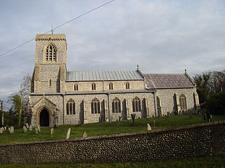
Oulton is a village and civil parish in Norfolk, England. Nearby towns are Reepham and Aylsham. The parish covers an area of 10.58 km2 (4.08 sq mi) and had a population of 196 in 74 households at the 2001 census, reducing slightly to a population of 193 in 81 households at the 2011 census. The village is dispersed with one area of settlement in the vicinity of the church of Saints Peter and Paul, and another area along Oulton Street to the east.

<span class="mw-page-title-main">Thurning, Norfolk</span> Village in Norfolk, England

Thurning is a small dispersed village and civil parish in the English county of Norfolk and district of North Norfolk, near the border with Broadland. The population at the 2011 Census remained less than 100 and is recorded together with the neighbouring civil parish of Hindolveston.

<span class="mw-page-title-main">Heydon Hall</span> Country house in Norfolk, England

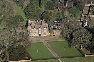
Heydon Hall is an Elizabethan house set in parkland near the village of Heydon, Norfolk, England.

References

  1. Census population and household counts for unparished urban areas and all parishes. Office for National Statistics & Norfolk County Council (2001). Retrieved 20 June 2009.
  2. "Inside Britain's privately owned villages". Country Life. 27 March 2021. Retrieved 14 April 2021.
  3. British History Online An Essay Towards A Topographical History of the County of Norfolk: Volume 6 (1807)
  4. 1 2 3 4 Heydon Conservation Area Character Statement (March 2009) Broadland District Council
  5. Historic England Church of St Peter and St Paul
  6. 1 2 William White (1845). History, Gazetteer, and Directory of Norfolk.
  7. "Heydon Hall, Norfolk". Historic England. Retrieved 14 April 2021.
  8. "The Hall". Heydon.co. Retrieved 14 April 2021.
  9. Historic England The Earle Arms, Heydon
  10. WhatPub Earle Arms
  11. 1 2 Norfolk Pubs Earle Arms - Heydon
  12. flickr
  13. Norfolk County Council Tithe maps
  14. Norfolk Heritage Explorer
  15. Norfolk Rural Schools Survey
  16. Hickey, Daniel. "Rare organ coming back to life after £60k restoration". Eastern Daily Press. Retrieved 25 June 2023.
  17. 1 2 "Heydon". Literary Norfolk.
  18. Historic England Jubilee Memorial
  19. Vision of Britain
  20. Heydon / Salle Rural Conservation Area Character Statement (March 2008) Broadland District Council
  21. Eastern Daily Press 24 June 2013
  22. EDP End of an era for blacksmiths workshop October 2007
  23. "The Village". Heydon.co. Retrieved 14 April 2021.
  24. "Living at Heydon". Heydon.co. Retrieved 14 April 2021.
  25. "Filming locations, Heydon". imdb.com.
  26. Larsen, Darl (2008). Monty Python's Flying Circus: An Utterly Complete, Thoroughly Unillustrated, Absolutely Unauthorized Guide to Possibly All the References From Arthur "Two Sheds" Jackson to Zambesi. Scarecrow Press. ISBN   978-0810861312.
  27. Historic England Cropton Hall, Heydon
  28. 1 2 Broadland District Council Polling districts, wards and parishes (2019)
  29. Church of England Heydon: St Peter & St Paul
  30. "Heydon Tug of War | 28 May 2017 | Heydon, Norfolk".
  31. "PETER BECK Headmaster who caned Prince Charles — twice" (obituary) in The Times dated 4 June 2002, p. 27, from The Times Digital Archive, accessed 16 September 2013
  32. Companies House Byrne, Johnny
  33. Literary Norfolk
  34. Audioboom
  35. Companies House Ashbee, Michael

Commons-logo.svg Media related to Heydon, Norfolk at Wikimedia Commons