
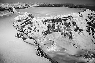
Mount Garibaldi is a dormant stratovolcano in the Garibaldi Ranges of the Pacific Ranges in southwestern British Columbia, Canada. It has a maximum elevation of 2,678 metres and rises above the surrounding landscape on the east side of the Cheakamus River in New Westminster Land District. In addition to the main peak, Mount Garibaldi has two named sub-peaks. Atwell Peak is a sharp, conical peak slightly higher than the more rounded peak of Dalton Dome. Both were volcanically active at different times throughout Mount Garibaldi's eruptive history. The northern and eastern flanks of Mount Garibaldi are obscured by the Garibaldi Névé, a large snowfield containing several radiating glaciers. Flowing from the steep western face of Mount Garibaldi is the Cheekye River, a tributary of the Cheakamus River. Opal Cone on the southeastern flank is a small volcanic cone from which a lengthy lava flow descends. The western face is a landslide feature that formed in a series of collapses between 12,800 and 11,500 years ago. These collapses resulted in the formation of a large debris flow deposit that fans out into the Squamish Valley.

Sirmilik National Park is a national park located in Qikiqtaaluk, Nunavut, Canada, established in 1999. Situated within the Arctic Cordillera, the park is composed of three areas: most of Bylot Island with the exception for a few areas that are Inuit-owned lands, Kangiqłuruluk, and Baffin Island's Borden Peninsula. Much of the park is bordered by water.
The Klinaklini River is one of the major rivers of the Pacific Ranges section of the Coast Mountains in the Canadian province of British Columbia. It originates in the Pantheon Range and empties into the head of Knight Inlet.
Bugaboo Provincial Park is a provincial park in British Columbia, Canada, located in the central Purcell Mountains.

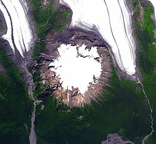
Hoodoo Mountain, sometimes referred to as Hoodoo Volcano, is a potentially active stratovolcano in the Northern Interior of British Columbia, Canada. It is located 25 kilometres northeast of the Alaska–British Columbia border on the north side of the Iskut River opposite of the mouth of the Craig River. With a summit elevation of 1,850 metres and a topographic prominence of 900 metres, Hoodoo Mountain is one of many prominent peaks within the Boundary Ranges of the Coast Mountains. Its flat-topped summit is covered by an ice cap more than 100 metres thick and at least 3 kilometres in diameter. Two valley glaciers surrounding the northwestern and northeastern sides of the mountain have retreated significantly over the last hundred years. They both originate from a large icefield to the north and are the sources of two meltwater streams. These streams flow along the western and eastern sides of the volcano before draining into the Iskut River.
Mount Edziza, sometimes called Edziza Mountain or Edziza Peak, is a stratovolcano in Cassiar Land District of northwestern British Columbia, Canada. It is located on the Big Raven Plateau of the Tahltan Highland which extends along the western side of the Stikine Plateau. The mountain has an elevation of 2,786 metres, making it the highest volcano of the Mount Edziza volcanic complex. However, it had an elevation of at least 3,396 metres before its original summit was likely destroyed by a violent, climactic eruption in the geologic past; its current flat summit contains an ice-filled, 2-kilometre (1.2-mile) in diameter crater. Mount Edziza contains several lava domes, cinder cones and lava fields on its flanks, as well as an ice cap that is characterized by several outlet glaciers stretching out to lower altitudes. All sides of the mountain are drained by tributaries of Mess Creek and Kakiddi Creek which are situated within the Stikine River watershed.
Mount Stanley Baldwin is a mountain located in the Premier Range of the Cariboo Mountains in the east-central interior of British Columbia, Canada. The mountain is located at the head of the Gilmour Glacier. It was originally named Mount Challenger by Allen Carpé during his 1924 ascent of the mountain.
The Iskut volcanic field is a group of volcanoes and lava flows on and adjacent to the Alaska–British Columbia border in the Boundary Ranges of the Coast Mountains. All the volcanoes in this volcanic field are situated in British Columbia along the Iskut and Unuk rivers and their tributaries, with lava flows having reached Alaska. The oldest volcanoes in the Iskut volcanic field are Little Bear Mountain and Hoodoo Mountain, which are 146,000 and 85,000 years old, respectively. Younger volcanic centres include Second Canyon, King Creek, Tom MacKay Creek, Snippaker Creek, Iskut Canyon, Cone Glacier, Cinder Mountain and Lava Fork, all of which formed in the last 70,000 years. All of the volcanoes are mafic in composition except for Hoodoo Mountain which consists of peralkaline rocks. The latest volcanic eruption took place from the Lava Fork volcano in 1800, although an uncertain 1904 eruption is also attributed to this volcano.
The Franklin Glacier Complex is a deeply eroded volcano in the Waddington Range of southwestern British Columbia, Canada. Located about 65 km (40 mi) northeast of Kingcome, this sketchily known complex resides at Franklin Glacier near Mount Waddington. It is over 2,000 m (6,600 ft) in elevation and because of its considerable overall altitude, a large proportion of the complex is covered by glacial ice.

The Mount Edziza volcanic complex is a group of volcanoes and associated lava flows in northwestern British Columbia, Canada. Located on the Tahltan Highland, it is 40 kilometres southeast of Telegraph Creek and 85 kilometres southwest of Dease Lake. The complex encompasses a broad, steep-sided lava plateau that extends over 1,000 square kilometres. Its highest summit is 2,786 metres in elevation, making the MEVC the highest of four large complexes in an extensive north–south trending volcanic region. It is obscured by an ice cap characterized by several outlet glaciers that stretch out to lower altitudes.
The Craig River is a transboundary river tributary of the Iskut River in Southeast Alaska, United States, and the northwest part of the province of British Columbia, Canada. Originating in Alaska, where it is sometimes called the South Fork Craig River, the Craig flows into British Columbia, generally in a northeast then northwest direction for about 50 km (31 mi) to join the Iskut River about 2 km (1.2 mi) east of the confluence of the Iskut and Hoodoo River. Its main tributary is the Jekill River.
The Twin River is a tributary of the Iskut River in the northwest part of the province of British Columbia, Canada. From its source in Twin Glacier the Twin River flows south for about 11 km (6.8 mi), east of Hoodoo Mountain to the Iskut River north of the Craig River watershed. The Twin River's watershed covers 203 km2 (78 sq mi), and its mean annual discharge is an estimated 16.7 m3/s (590 cu ft/s). The river's watershed's land cover is classified as 77.2% snow/glacier, 9.8% barren, 4.5% conifer forest, and small amounts of other cover.
The Hoodoo River is a tributary of the Iskut River in the northwest part of the province of British Columbia, Canada, located west of Hoodoo Mountain and the Twin River in Cassiar Land District. From its source in Hoodoo Glacier the Hoodoo River flows south for about 10 km (6.2 mi) to the Iskut River northwest of the mouth of the Craig River.
Twin Glacier is a glacier in northwestern British Columbia, Canada, located on the northern and eastern flanks of Hoodoo Mountain. It lies at the headwaters of the Twin River. The glacier originates from the Andrei Icefield.

Asperity Mountain is a mountain located in British Columbia, Canada, rising to 3,716 metres (12,192 ft). It is located between Tellot and Tiedemann Glaciers on the north and south respectively, in the Waddington Range, a subrange of the Pacific Ranges. The gorge of the Homathko River runs north to south on the east side of the mountain, carrying runoff from the mountain and glaciers to the Pacific Ocean.
A mountain formerly known as Mount Pétain, but with no current official name, is located on the border of the Canadian provinces of Alberta and British Columbia (BC) on the Continental Divide.

Mount Barnard, also named Boundary Peak 160, is a mountain in Alaska and British Columbia, located on the Canada–United States border, and part of the Alsek Ranges of the Saint Elias Mountains. In 1923 Boundary Peak 160 was named Mount Barnard in honour of Edward Chester Barnard, a U.S. Boundary Commissioner from 1915 to 1921 and chief topographer of the United States and Canada Boundary Survey from 1903 to 1915. The first ascent of Mount Barnard was made on August 24, 1966, from the head of Tarr Inlet by D. Kenyon King, Peter H. Robinson and David P. Johnston. The details on file with Peak Service at Bartlett Cove, Glacier Bay National Monument, Gustavus, Alaska.

Franklin Glacier is a mountain glacier in the Waddington Range of the Pacific Ranges in southwestern British Columbia, Canada. It lies at the head of the Franklin River adjacent to Mount Waddington, the highest mountain entirely within British Columbia.
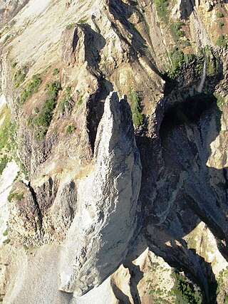
The Monument is a hoodoo in Cassiar Land District of the Northern Interior of British Columbia, Canada. It lies on the southwestern side of Hoodoo Mountain, a flat-topped stratovolcano in the Northern Cordilleran Volcanic Province. This light grey, needle-like rock formation has an elevation of about 1,100 m (3,600 ft) and rises more than 100 m (330 ft) high, gradually decreasing in diameter to a very sharp point. It is slightly oval in cross-section and stands out against the volcanic rocks comprising Hoodoo Mountain.
The Andrei Icefield is a large icefield in the Boundary Ranges of the Coast Mountains in northwestern British Columbia, Canada. It is located 130 km (81 mi) northwest of the community of Stewart in Cassiar Land District. The icefield is the source of many valley glaciers, including Hoodoo Glacier and Twin Glacier, which lie at the headwaters of Hoodoo River and Twin River, respectively. Between these two glaciers is Hoodoo Mountain, a flat-topped stratovolcano of the Northern Cordilleran Volcanic Province. Other glaciers originating from the Andrei Icefield include Andrei Glacier, Porcupine Glacier, Johnson Glacier and Choquette Glacier, the latter of which lies at the headwaters of Choquette River.

