Kaitaia

Last updated

Kaitaia
Main Street New Zealand - Kaitaia, Northland, October 2007.jpg
Kaitaia
Coordinates: 35°6′45″S173°15′46″E / 35.11250°S 173.26278°E / -35.11250; 173.26278
Country New Zealand
Island North Island
Region Northland
Territorial authority Far North District
Ward Te Hiku
Electorates
Government
  Territorial Authority Far North District Council
  Regional council Northland Regional Council
Area
[1]
  Total8.48 km2 (3.27 sq mi)
Population
 (June 2023) [2]
  Total6,390
  Density750/km2 (2,000/sq mi)
Time zone UTC+12 (NZST)
  Summer (DST) UTC+13 (NZDT)
Postcode(s)
0410
Area code 09

Kaitaia (Māori : Kaitāia) is a town in the Far North District of New Zealand, at the base of the Aupōuri Peninsula, about 160 km northwest of Whangārei. It is the last major settlement on State Highway 1. Ahipara Bay, the southern end of Te Oneroa-a-Tōhē / Ninety Mile Beach, is 5 kilometres (3.1 mi) west.

Contents

The main industries are forestry and tourism. The population is 6,390 as of June 2023, [2] which makes it the second-largest town in the Far North District, after Kerikeri.

The name Kaitāia means 'ample food', kai being the Māori word for food. [3]

The Muriwhenua are a group of six northern Māori iwi occupying the northernmost part of the North Island surrounding Kaitaia.

History and culture

European settlement

The Kaitaia Mission Station was established between 1833 and 1834 after a series of visits by Church Missionary Society (CMS) representatives including Samuel Marsden, and at different times, Joseph Matthews and William Gilbert Puckey. [4] Puckey and Matthews had married two sisters, Matilda and Mary Ann Davis respectively, (daughters of Richard Davis, a lay missioner based at Waimate North). They formed a tight band, initially living together in raupo huts, and then in houses they built.

As Puckey and the sisters were fluent in Maori, (Puckey having arrived in New Zealand in 1819 with his father, William Puckey, and the Davis family in 1823), they spoke Maori when together, to help Joseph Matthews pick up the language. Both families grew and intermarried, forming the basis of the early Pākehā settler community. At one point, the Church Missionary Society decided that either Puckey or Matthews should move to a new location to the south to facilitate the spread of the word, but Nōpera Panakareao wrote a heartfelt letter to the CMS committee, pleading not to take away 'one of the two candlesticks'.

A landscape view of the southern part of Kaitaia taken on Okahu Road, the highest point in the town. View of south Kaitaia from Okahu Road.jpg
A landscape view of the southern part of Kaitaia taken on Okahu Road, the highest point in the town.

In February 1841, about 500 Maori were present at a CMS service. [5] In 1852 arguments developed between one chief and his tribe, however the impact of the missionaries meant that the old ways of settling disputes had passed. [6]

Richard Matthews, the brother of Rev. Joseph Matthews, arrived in the Bay of Islands in December 1835 and for a time, joined his brother in Kaitaia. Richard Matthews had been a lay missionary on the second voyage of HMS Beagle with Charles Darwin. [7] Richard Matthews served the CMS as a lay catechist at Kaitaia. In 1838 he married Johanna Blomfield, the sister of Mrs Martha Blomfield Clarke, whose husband George was a CMS missionary at Te Waimate mission. In 1840 Richard and Johanna Matthews helped set up a missionary station at Whanganui. [8]

There were plans to extend the Okaihau Branch railway to Kaitaia and construction was started in the 1920s, but with the line nearly complete to Rangiahua, a review in 1936 determined that the line would not be viable and construction was abandoned. The line terminated in Okaihau until it was closed on 1 November 1987. D 221, a steam tank locomotive, has been on static display at Centennial Park since 1967. [9]

Marae

There are five marae located within 10kms of Kaitāia

21st century

In October 2020, a fire occurred at the former Kaitaia Bowling Club on Matthews Avenue. [12] Alarms were raised at 6:01am on Friday. The fire was caused by an electrical fault that had sparked in the kitchen area on the upper floor, causing the northern half of the building to burn. The building, prior to the blaze, was used as a residential dwelling.

A few months later in March 2021, the building was set on fire again, [13] causing the entire building to set ablaze. Alarms were raised at around 2:30pm. Police suspected that the blaze was 'deliberately lit'. The building was demolished upon the closing of the property.

Demographics

Statistics New Zealand describes Kaitaia as a small urban area. It covers 8.48 km2 (3.27 sq mi) [1] and had an estimated population of 6,390 as of June 2023, [2] with a population density of 754 people per km2.

Historical population
YearPop.±% p.a.
20065,202    
20134,887−0.89%
20185,871+3.74%
Source: [14]

Kaitaia had a population of 5,871 at the 2018 New Zealand census, an increase of 984 people (20.1%) since the 2013 census, and an increase of 669 people (12.9%) since the 2006 census. There were 1,881 households, comprising 2,799 males and 3,072 females, giving a sex ratio of 0.91 males per female, with 1,590 people (27.1%) aged under 15 years, 1,179 (20.1%) aged 15 to 29, 2,196 (37.4%) aged 30 to 64, and 909 (15.5%) aged 65 or older.

Ethnicities were 49.9% European/Pākehā, 65.9% Māori, 7.9% Pacific peoples, 5.2% Asian, and 1.2% other ethnicities. People may identify with more than one ethnicity.

The percentage of people born overseas was 9.6, compared with 27.1% nationally.

Of those people who chose to answer the census's question about religious affiliation, 36.7% had no religion, 41.5% were Christian, 10.4% had Māori religious beliefs, 1.0% were Hindu, 0.3% were Muslim, 0.7% were Buddhist and 1.2% had other religions.

Of those at least 15 years old, 348 (8.1%) people had a bachelor or higher degree, and 1,203 (28.1%) people had no formal qualifications. 201 people (4.7%) earned over $70,000 compared to 17.2% nationally. The employment status of those at least 15 was that 1,452 (33.9%) people were employed full-time, 531 (12.4%) were part-time, and 483 (11.3%) were unemployed. [14]

Individual statistical areas
NameArea (km2)PopulationDensity (per km2)HouseholdsMedian ageMedian income
Kaitaia East5.272,38845376531.4 years$19,700 [15]
Kaitaia West3.213,4831,0851,11632.9 years$19,700 [16]
New Zealand37.4 years$31,800

Climate

Kaitaia has a humid subtropical climate (Cfbl) according to the Trewartha climate classification system or an oceanic climate (Cfb) according to Köppen system. Summers are usually warm, while winters are usually wet and mild. Precipitation is heavy year round in the form of rain, which peaks during the months of May - September. [17]

Climate data for Kaitaia (1991–2020)
MonthJanFebMarAprMayJunJulAugSepOctNovDecYear
Mean daily maximum °C (°F)23.6
(74.5)
24.5
(76.1)
23.0
(73.4)
20.9
(69.6)
18.4
(65.1)
16.2
(61.2)
15.4
(59.7)
15.6
(60.1)
16.7
(62.1)
17.9
(64.2)
19.4
(66.9)
21.7
(71.1)
19.4
(66.9)
Daily mean °C (°F)19.2
(66.6)
20.0
(68.0)
18.6
(65.5)
16.9
(62.4)
14.8
(58.6)
12.8
(55.0)
12.0
(53.6)
12.2
(54.0)
13.1
(55.6)
14.2
(57.6)
15.6
(60.1)
17.7
(63.9)
15.6
(60.1)
Mean daily minimum °C (°F)14.8
(58.6)
15.6
(60.1)
14.3
(57.7)
12.9
(55.2)
11.2
(52.2)
9.4
(48.9)
8.5
(47.3)
8.8
(47.8)
9.6
(49.3)
10.6
(51.1)
11.7
(53.1)
13.8
(56.8)
11.8
(53.2)
Average rainfall mm (inches)75.0
(2.95)
86.0
(3.39)
84.7
(3.33)
98.8
(3.89)
130.5
(5.14)
149.9
(5.90)
168.1
(6.62)
137.0
(5.39)
121.7
(4.79)
90.4
(3.56)
76.3
(3.00)
101.6
(4.00)
1,320
(51.96)
Average rainy days (≥ 1.0 mm)6.16.57.610.113.214.715.915.512.810.49.29.9131.9
Average relative humidity (%)80.183.583.382.085.387.087.184.381.482.078.979.582.9
Mean monthly sunshine hours 233.8199.6200.0163.9146.5127.4139.5161.3169.7194.7193.7202.22,132.3
Source: NIWA Climate Data [18]

Transport

A photograph of the Te Ahu Centre, where the town library, information sites, and InterCity bus stops are. View of Te Ahu Center in Kaitaia.jpg
A photograph of the Te Ahu Centre, where the town library, information sites, and InterCity bus stops are.

InterCity operates a daily bus service to and from Auckland via Kerikeri. [19] Community Business & Environment Centre (CBEC) runs a service called Busabout to Ahipara, Mangonui and Pukenui. [20]

Kaitaia Airport has services from Auckland and is the only airport in the upper Far North District. Air New Zealand discontinued their services in April 2015. [21] Barrier Air has since taken over services to Auckland. [22]

Economy

Tourism

Kaitaia is one of the main centres in the Far North of New Zealand. It is near to popular tourist destinations such as Ahipara and is on State Highway 1 which leads up to Cape Reinga. The town's slogan is "Where journeys begin". [23]

An annual Snapper Surf Casting Competition is held in March, on Te Oneroa-a-Tōhē (Ninety Mile Beach) Snapper Bonanza Surf Casting Competition.

Forestry

The Aupouri Forest, to the North of Kaitaia, provides pine logs which are processed at the Juken Nissho Mill in Kaitaia.

Extraction of ancient swamp Kauri (Agathis australis), is a contentious industry. [24]

Agriculture, horticulture and viticulture

Kaitaia lies within the Awanui River catchment. The area supports dairy and dry stock farming, predominantly sheep and beef. Further north of Kaitaia, the avocado industry flourishes, with orchards dispersed throughout the immediate area.

Wine is a growing commodity. One of the largest vineyards in the area is the Karikari Estate.

Mānuka honey is another industry experiencing growth. [25]

Education

Kaitaia Primary School, Kaitaia Intermediate and Kaitaia College are the main primary, intermediate and secondary schools. The rolls are 266, [26] 186, [27] and 673, [28] respectively.

Te Kura Kaupapa Māori o Pukemiro is a full primary (years 1-8) school [29] with a roll of 147. It is a Kura Kaupapa Māori school which teaches fully in the Māori language.

Pompallier School is a Catholic full primary (years 1-8) school with a roll of 138. [30]

Kaitaia Abundant Life School was a Christian composite school (years 1-13). [31] It was established in 1988 as a private primary school, and extended to secondary students in 1992. It became a state integrated school in 1996. [32] The school closed and exited the state system at the end of Term 2, 2023. The school’s Trust believed that it was no longer possible to offer an education determined by their beliefs due to government and Ministry legislation, policy, and curriculum initiatives. These include: Gender neutral requirements, the Conversion Practices Prohibition Legislation Act 2022, and the curriculum’s requirements around relationship and sexuality guidelines. [33] [34]

Oturu School is a primary school to the north east serving years 1-8, with a roll of 134. [35]

All these schools are co-educational. Rolls are as of February 2024. [36]

NorthTec polytechnic also has a campus in Kaitaia. [37]

Notable people

Notable people who have lived in Kaitaia:

Related Research Articles

<span class="mw-page-title-main">Tokomaru Bay</span> Town in the North Island of New Zealand

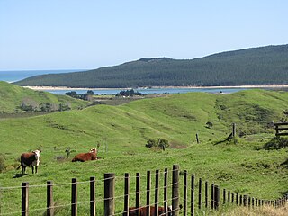
Tokomaru Bay is a small beachside community on the remote East Coast of New Zealand's North Island. It is 91 km north of Gisborne, on State Highway 35, and close to Mount Hikurangi. The district was originally known as Toka-a-Namu, which refers to the abundance of sandflies. Over the years the name was altered to Tokomaru Bay.

<span class="mw-page-title-main">Ngāti Kahungunu</span> Māori iwi in New Zealand

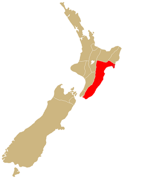
Ngāti Kahungunu is a Māori iwi located along the eastern coast of the North Island of New Zealand. The iwi is traditionally centred in the Hawke's Bay and Wairārapa regions. The Kahungungu iwi also comprises 86 hapū (sub-tribes) and 90 marae.

<span class="mw-page-title-main">Ōtaki, New Zealand</span> Settlement in Wellington Region, New Zealand

Ōtaki is a town in the Kāpiti Coast District of the North Island of New Zealand, situated half way between the capital city Wellington, 70 km (43 mi) to the southwest, and Palmerston North, 70 km (43 mi) to the northeast.

<span class="mw-page-title-main">Te Aupōuri</span> Māori iwi in New Zealand

Te Aupōuri is the second northernmost Māori iwi, located north of Kaitaia, Northland, New Zealand, a region known as the Te Hiku o te Ika. The iwi is one of the six Muriwhenua iwi of the far north of the North Island.

<span class="mw-page-title-main">Te Arawa</span> Confederation of Māori iwi and hapū (tribes and sub-tribes)

Te Arawa is a confederation of Māori iwi and hapū of New Zealand who trace their ancestry to the Arawa migration canoe (waka). The tribes are based in the Rotorua and Bay of Plenty areas and have a population of around 60,117 according to the 2018 census making it the 6th biggest iwi in New Zealand. The Te Arawa iwi also comprises 56 hapū (sub-tribes) and 31 marae.

<span class="mw-page-title-main">Manunui</span> Place in Manawatū-Whanganui, New Zealand

Manunui is a small Whanganui River settlement, about 6 kilometres (3.7 mi) east of Taumarunui on State Highway 4, in New Zealand's King Country. It was once known as Waimarino, but John Burnand of the Ellis and Burnand sawmilling firm renamed it Manunui around 1905.

<span class="mw-page-title-main">Ngāti Pūkenga</span> Māori iwi in New Zealand

Ngāti Pūkenga is a Māori iwi centred in Tauranga in the Bay of Plenty region of New Zealand. Its rohe extends to Mayor Island / Tuhua and Waihi in the north, to the Kaimai Range in the west, south of Te Puke and to Maketu in the east, and it has tribal holdings in Whangarei, Hauraki and Maketu.

Kaeo is a township in the Far North District of New Zealand, located some 22 km (14 mi) northwest of Kerikeri. The town's name comes from the Māori-language name of the New Zealand freshwater mussel, which is found in nearby rivers.

<span class="mw-page-title-main">Nūhaka</span> Settlement in Hawkes Bay Region, New Zealand

Nūhaka is a small settlement in the northern Hawke's Bay Region of New Zealand's eastern North Island, lying on State Highway 2 between Wairoa and Gisborne. The road to Mahia turns off the highway at Nūhaka.

<span class="mw-page-title-main">Ahipara</span> Place in Northland Region, New Zealand

Ahipara is a town and locality in Northland, New Zealand at the southern end of Ninety Mile Beach, with the Tauroa Peninsula to the west and Herekino Forest to the east. Ahipara Bay is to the north west. Kaitaia is 14 km to the north east, and Pukepoto is between the two.

Awanui is an historical river port in the far north of New Zealand, on the banks of the Awanui River just before it flows into Rangaunu Bay. Awanui lies at the south end of the Aupouri Peninsula in the Far North District Council of the Northland Region, approximately 7 km north of Kaitaia. The river port has ceased operation and a recreational wharf is located at Unahi, on the shore of Rangaunu Bay, approximately 3 km north of the township. The traditional name of Awanui was Kaiwaka and Awanui proper refers to the "River at Kaiwaka". According to the 2013 New Zealand census, Awanui has a population of 339, a decrease of 9 people since the 2006 census.

Pukepoto is a town in Northland, New Zealand. It lies south west of Kaitaia and north east of Ahipara. The Herekino Forest lies to the south east.

<span class="mw-page-title-main">Whangape Harbour</span> Harbor in Northland, New Zealand

Whangape Harbour is a harbour on the west coast of Northland, New Zealand. There is a settlement called Whangape on the northern side of the harbour. Another, called Pawarenga, is located on the southern side. Kaitaia is 42 km north east.

<span class="mw-page-title-main">Ngāi Takoto</span> Māori iwi in New Zealand

Ngāi Takoto is a Māori iwi from Northland, New Zealand. The iwi is one of the six Muriwhenua iwi of the far north of the North Island. Ngāi Takoto trace their whakapapa (ancestry) back to Tuwhakatere, and trace their arrival in New Zealand to the Kurahaupo waka (canoe). The rohe of the iwi is focused on the upper North Island and extends to Kermadec Islands, Three Kings Island, Cape Reinga, Pao Island, Ninety Mile Beach, Waimimiha River, Ohaku hills, Whangatane River, Rangaunu Harbour and North Cape.

<span class="mw-page-title-main">Ngāti Hauā</span> Māori iwi in New Zealand

Ngāti Hauā is a Māori iwi of the eastern Waikato of New Zealand. It is part of the Tainui confederation. Its traditional area includes Matamata, Cambridge, Maungakawa, the Horotiu district along the Waikato River and the Maungatautari district, and its eastern boundary is the Kaimai Range. Leaders of the tribe have included Te Waharoa, his son Wiremu Tamihana and Tamihana's son Tupu Taingakawa. The tribe has played a prominent role in the Māori King Movement, with Tamihana and descendants being known as the "Kingmakers".

<span class="mw-page-title-main">Ngāti Kurī</span> Māori iwi in New Zealand

Ngāti Kurī is a Māori iwi from Northland, New Zealand. The iwi is one of the five Muriwhenua iwi of the far north of the North Island. Ngāti Kurī trace their whakapapa (ancestry) back to Pōhurihanga, the captain of the waka (canoe) Kurahaupō. Kurī, in Māori, means "dog". The rohe of the iwi is focused on the most northern tip of the North Island and includes the Kermadec Islands, Manawatāwhi / Three Kings Islands, Cape Reinga / Te Rerenga Wairua, Ninety Mile Beach, Parengarenga Harbour, Te Kao and Houhora.

<span class="mw-page-title-main">Te Rarawa</span> Māori iwi in New Zealand

Te Rarawa is a Māori iwi of Northland, New Zealand. The iwi is one of five Muriwhenua iwi of the far north of the North Island.

Hone Tana Papahia was a New Zealand Anglican clergyman, missionary. Of Māori descent, he identified with the Ngāpuhi iwi and Te Horohuhare and Ngati Haua hapū of Te Rarawa iwi. He was the son of Wiremu Tana Papahia. He was born in Orongotea on the north-west shore of the Hokianga Harbour in about 1856.

Ngāti Kauwhata is a Māori iwi (tribe) located in the Manawatū-Whanganui region of New Zealand. The iwi has ancestral ties to Tainui Waka and Maungatautari. The iwi has two main marae, Kauwhata Marae & Aorangi Marae.

<span class="mw-page-title-main">Pareaute Nathan</span>

Pareaute Polly Nathan is a New Zealand Māori educator and weaver. In the 2016 Queen's Birthday Honours, she was awarded the Queen's Service Medal, for services to Māori and education.

References

  1. 1 2 "ArcGIS Web Application". statsnz.maps.arcgis.com. Retrieved 24 March 2022.
  2. 1 2 3 "Subnational population estimates (RC, SA2), by age and sex, at 30 June 1996-2023 (2023 boundaries)". Statistics New Zealand . Retrieved 25 October 2023. (regional councils); "Subnational population estimates (TA, SA2), by age and sex, at 30 June 1996-2023 (2023 boundaries)". Statistics New Zealand . Retrieved 25 October 2023. (territorial authorities); "Subnational population estimates (urban rural), by age and sex, at 30 June 1996-2023 (2023 boundaries)". Statistics New Zealand . Retrieved 25 October 2023. (urban areas)
  3. "Welcome..." Archived from the original on 14 November 2009. Retrieved 8 February 2010.
  4. "Muriwhenua Land Report - The People and the Land" (PDF). Waitangi Tribunal. p. 48. Archived (PDF) from the original on 15 October 2008. Retrieved 3 September 2008.
  5. Matthews, Joseph. "The Church Missionary Gleaner, August 1841" . A Church Mission in New Zealand. Adam Matthew Digital . Retrieved 9 October 2015.
  6. "The Church Missionary Gleaner, October 1853" . Kaitaia. Adam Matthew Digital . Retrieved 18 October 2015.
  7. Darwin, Charles. Journal of a Voyage Round the World, 1831-36
  8. "Richard Matthews". Pre-1839 foreigners in NZ. Archived from the original on 23 February 2014.
  9. "Weka Pass Railway's page on D 221". Archived from the original on 27 September 2007.
  10. "Te Kāhui Māngai directory". tkm.govt.nz. Te Puni Kōkiri. Archived from the original on 22 June 2018. Retrieved 24 February 2019.
  11. "Māori Maps". maorimaps.com. Te Potiki National Trust. Archived from the original on 27 January 2018. Retrieved 24 February 2019.
  12. "Kaitaia's old bowling club burns". NZ Herald. Retrieved 8 June 2021.
  13. "Another fire at the old bowling club". NZ Herald. Retrieved 8 June 2021.
  14. 1 2 "Statistical area 1 dataset for 2018 Census". Statistics New Zealand. March 2020. Kaitaia East (100700) and Kaitaia West (100800).
  15. 2018 Census place summary: Kaitaia East
  16. 2018 Census place summary: Kaitaia West
  17. "Climate Data". NIWA. Archived from the original on 29 May 2012. Retrieved 2 November 2007.
  18. "Climate data and activities". NIWA. Archived from the original on 20 May 2024. Retrieved 20 May 2024.
  19. "InterCity (Kaitaia)". Archived from the original on 24 September 2016. Retrieved 7 June 2016.
  20. "Busabout North". Archived from the original on 17 June 2016. Retrieved 7 June 2016.
  21. "Air NZ ends Auckland to Kaitaia flights as new airline steps in". TVNZ ONE News. 28 April 2015. Archived from the original on 19 September 2016. Retrieved 7 June 2016.
  22. Peter de Graaf (13 February 2015). "New air service inbound at Kaitaia". Northern Advocate. Archived from the original on 2 April 2015. Retrieved 13 February 2015.
  23. "Kia Ora: Kaitaia". New Zealand Herald. Archived from the original on 25 December 2018.
  24. "Buried treasure". New Zealand Geographic. Archived from the original on 27 January 2020. Retrieved 24 April 2020.
  25. "Gold rush". New Zealand Geographic. Archived from the original on 24 May 2019. Retrieved 24 April 2020.
  26. Education Counts: Kaitaia Primary
  27. Education Counts: Kaitaia Intermediate
  28. Education Counts: Kaitaia College
  29. Education Counts: Te Kura Kaupapa Maori o Pukemiro
  30. Education Counts: Pompallier School
  31. Education Counts: Kaitaia Abundant Life School
  32. "Abundant Life School Profile" (DOC). Archived from the original on 14 October 2008. Retrieved 15 January 2008.
  33. "Education Report: Consultation on the cancellation of the integration agreement for Kaitaia Abundant Life School (238)" (PDF).
  34. "Northland school closing as it can't practise conversion therapy". One News. 12 March 2023.
  35. Education Counts: Oturu School
  36. "New Zealand Schools Directory". New Zealand Ministry of Education. Retrieved 14 March 2024.
  37. "Kaitaia". NorthTec. Archived from the original on 12 March 2010. Retrieved 4 March 2010.
  38. Harris, Jan. "Sophia Louisa Taylor". Dictionary of New Zealand Biography . Ministry for Culture and Heritage . Retrieved 4 March 2012.
  39. "The sporting Yates family". National Library of New Zealand. Archived from the original on 25 December 2018. Retrieved 25 December 2018.