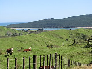
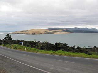
Kohukohu is situated on the northern shore of the harbour where it splits into two rivers, the Mangamuka River branching inland to the northeast and the Waihou River leading towards the east past Mangungu, Horeke and Rangiahua.
Where the harbour divides there is a small island called Motiti which was painted by Augustus Earle, the first European artist to spend several months in New Zealand, during his visit to the Hokianga in 1827. He wrote "we were sailing up a spacious sheet of water, which became considerably wider after entering it; while majestic hills rose on each side .... looking up the river we beheld various headlands stretching into the water and gradually contracting its width, 'till they became fainter and fainter in the distance and all was lost in the azure of the horizon".
History and culture
Pre-European settlement
According to Te Tai Tokerau tradition, the legendary Polynesian explorer Kupe visited the area prior to his return voyage to Hawaiiki. Angry at the food from the Hāngī (earth oven) being insufficiently cooked, he swore at those responsible.[3]Kohukohu is Māori for a swearword or expletive.[4]
Kohukohu in 1918. On the foreshore are the Kohukohu Hotel, the Bank of New Zealand, D B Wallace Store, Laslett's Cash Store, and W L Sargeant (machinist)
European settlement
The first recorded European to enter the Hokianga Harbour arrived in 1819 and by the 1830s, Kohukohu was the heart of New Zealand's timber industry.[5] The country's first Catholic mass was celebrated 8 kilometres north of Kohukohu at Totara Point in 1838.[6] The Hokianga Sawmill Company built a sawmill in 1878.
For nearly one hundred years Kohukohu was an important timber milling town and the largest commercial centre on the north of the harbour. In 1900, the township had a population of almost 2,000 people.[7]
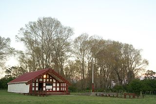
Marae
Kohukohu has three marae affiliated with the hapū Te Ihutai: Pateoro or Te Karae Marae and Pōwhiri meeting house which affiliates with Te Rarawa;[8] Pikipāria Marae and Ngarunui meeting house which affiliates with Ngāpuhi;[9] and Tauteihiihi Marae and Tokimatahourua meeting house.[10]
In October 2020, the Government committed $1,407,731 from the Provincial Growth Fund to upgrade Ngāi Tupoto Marae and 8 other marae of Te Rarawa, creating 100 jobs.[13]
New Zealand's oldest bridge
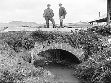
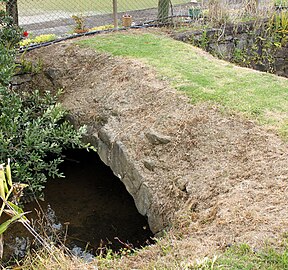
The Kohukohu footbridge near the centre of the town is the first stone bridge built in New Zealand, and is the oldest surviving bridge of any construction still in existence in the country.[14] It was built some time between 1843 and 1851 at the mouth of the Waihouuru Creek where it flowed into the Hokianga Harbour. At the time, ships from Sydney used sandstone blocks as ballast, which they left at Kohukohu in exchange for more-valuable timber, and these sandstone blocks were used to build the bridge. When a timber mill opened next to the bridge in 1879 sawdust was used to gradually reclaim the harbour, and the reclamation has buried most of the bridge, which is now about 100 m back from the foreshore. The bridge was registered in 2008 as a Category 1 Historic Place.[14]
Kohukohu footbridge
Kohukohu c. 1867-1869. The old stone bridge is clearly visible, before the harbour was filled in
Kohukohu bridge around 1900 to 1920, with the timber mill visible in the background
Kohukohu footbridge today
Kohukohu today
Hokianga Arch of Remembrance at Kohukohu
Today, Kohukohu is a community of 150 people who live within the village and approximately 350 who live in the surrounding area. The smaller settlements of Tauteihiihi, Motukaraka, Pikiparia, Te Karae, Mata, and Paponga are very close by. Kohukohu has a school, general store, café, art galleries, arts and crafts shop, hotel, voluntary fire and ambulance services, and a health clinic. There are also two churches and three marae within the locality.
In recent years,[when?] Kohukohu has become a destination for travellers who are attracted by its scenery, history, culture and arts.[15]
Demographics
Statistics New Zealand describes Kohukohu as a rural settlement. It covers 4.26km2 (1.64sqmi)[1] and had an estimated population of 190 as of June 2023,[2] with a population density of 45 people per km2. Kohukohu is part of the larger Kohukohu-Broadwood statistical area.[16]
Kohukohu had a population of 168 at the 2018 New Zealand census, unchanged since the 2013 census, and a decrease of 18 people (−9.7%) since the 2006 census. There were 81 households, comprising 78 males and 90 females, giving a sex ratio of 0.87 males per female. The median age was 58.0 years (compared with 37.4 years nationally), with 24 people (14.3%) aged under 15 years, 21 (12.5%) aged 15 to 29, 72 (42.9%) aged 30 to 64, and 54 (32.1%) aged 65 or older.
Ethnicities were 75.0% European/Pākehā, 37.5% Māori, 1.8% Pacific peoples, and 3.6% Asian. People may identify with more than one ethnicity.
Of those people who chose to answer the census's question about religious affiliation, 50.0% had no religion, 32.1% were Christian and 1.8% had other religions.
Of those at least 15 years old, 39 (27.1%) people had a bachelor's or higher degree, and 27 (18.8%) people had no formal qualifications. The median income was $19,500, compared with $31,800 nationally. 9 people (6.2%) earned over $70,000 compared to 17.2% nationally. The employment status of those at least 15 was that 33 (22.9%) people were employed full-time, 21 (14.6%) were part-time, and 9 (6.2%) were unemployed.[17]
Education
Kohukohu School is a co-educational full primary (years 1-8) school[18] with a roll of 35 students as of April 2023.[19] The school was established in 1883, but moved to a new location in 1972 because the ground on the original site was unstable. The original site with the original school building is now a historic reserve.[20]
↑ Shadbolt, Maurice (2010). Reader's Digest Guide to New Zealand. Reader's Digest. A bawdy timber town from the 1830s
↑ Shadbolt, Maurice (2010). Reader's Digest Guide to New Zealand. Reader's Digest. New Zealand's first Catholic mass was celebrated near by in 1838; a memorial 8 kilometres north on Totara Point marks the site.
↑ Shadbolt, Maurice (2010). Reader's Digest Guide to New Zealand. Reader's Digest. with a population of 20000 at the turn of the century, it now musters less than 200
Katikati is a town in New Zealand located on the Uretara Stream near a tidal inlet towards the northern end of Tauranga Harbour, 28 kilometres south of Waihi and 40 kilometres northwest of Tauranga. State Highway 2 passes through the town; a bypass scheduled to have begun construction in 2008 is on hold.
Matakana Island is located in the western Bay of Plenty in New Zealand's North Island. A long, flat barrier island, it is 20 kilometres (12 mi) in length but rarely more than 3 kilometres (1.9 mi) wide. The island has been continuously populated for centuries by Māori tribes that are mostly associated with Ngāi Te Rangi.
Murupara is a town in the Whakatāne District and Bay of Plenty Region of New Zealand's North Island. The town is in an isolated part of the region between the Kaingaroa Forest and Te Urewera protected area, on the banks of the Rangitaiki River, 65 kilometres southeast of Rotorua. Indigenous Māori also make up over 90% of the population.
Māhia Peninsula is located on the east coast of New Zealand's North Island, in the Hawke's Bay region, between the towns of Wairoa and Gisborne.
Ruatoria is a town in the Waiapu Valley of the Gisborne Region in the northeastern corner of New Zealand's North Island. The town was originally known as Cross Roads then Manutahi and was later named Ruatorea in 1913, after the Māori Master female grower Tōrea who had some of the finest storage pits in her Iwi at the time (Te-Rua-a-Tōrea). In 1925 the name was altered to "Ruatoria", although some texts retain the original spelling.
Taipa-Mangonui or Taipa Bay-Mangonui is a string of small resort settlements – Taipa, Cable Bay, Coopers Beach, and Mangōnui – that lie along the coast of Doubtless Bay and are so close together that they have run together to form one larger settlement.
Raetihi, a small town in the centre of New Zealand's North Island, is located at the junction of State Highways 4 and 49 in the Manawatū-Whanganui region. It lies in a valley between Tongariro and Whanganui National Parks, 11 kilometres west of Ohakune's ski fields.
Te Teko is a small inland town along the banks of the Rangitaiki River in the Bay of Plenty region of New Zealand's North Island.
Nūhaka is a small settlement in the northern Hawke's Bay Region of New Zealand's eastern North Island, lying on State Highway 2 between Wairoa and Gisborne. The road to Mahia turns off the highway at Nūhaka.
Te Araroa is a town in the Gisborne Region of the North Island of New Zealand. It is situated 175 km north of Gisborne city, along State Highway 35 between Tokata and Awatere. Te Araroa is the birthplace of noted Māori politician Sir Āpirana Ngata. Māori in the area are generally associated with the Ngāti Porou iwi. It is 100 metres from its local beach.
Herekino is a locality in Northland, New Zealand. It lies 26 km south west of Kaitaia. The Herekino Harbour, also called the Herekino River, is an estuary and inlet from the Tasman Sea to the west. The Herekino Forest, which contains a stand of large kauri, is to the north, and the Tauroa Peninsula lies to the north west.
Horeke is a settlement in the upper reaches of the Hokianga Harbour in Northland, New Zealand. Kohukohu is just across the harbour. The Horeke basalts are located near the town, and can be viewed on an easy stroll through the Wairere Boulders, a commercial park.
Omanaia is a settlement in the Hokianga area of Northland, New Zealand. It is part of the Hokianga South statistical area, which covers the southern side of Hokianga Harbour between Rawene and Koutu. For demographics of this area, see Rawene.
Whirinaki is a locality on the Whirinaki River in the south Hokianga, in Northland, New Zealand. The name means "to lean against a support". Highway 12 runs through it. Opononi lies to the south west, and Rawene lies to the north east.
Whangape Harbour is a harbour on the west coast of Northland, New Zealand. There is a settlement called Whangape on the northern side of the harbour. Another, called Pawarenga, is located on the southern side. Kaitaia is 42 km north east.
Panguru is a community in the northern Hokianga harbour, in Northland, New Zealand. The Whakarapa Stream flows from the Panguru Range in the Warawara Forest to the west, through Panguru and into the Hokianga.
Te Rarawa is a Māori iwi of Northland, New Zealand. The iwi is one of five Muriwhenua iwi of the far north of the North Island.
Waitōtara is a town in South Taranaki, New Zealand. Waverley is 10 km to the north-west, and Whanganui is 34 km to the south-east. State Highway 3 passes through it. The Waitōtara River flows past the east side of the town.
Mitimiti is a small settlement in Northland, New Zealand. It lies close to the Warawara Forest, between the mouths of the Whangape Harbour and Hokianga Harbour on Northland's west coast, 44 km west of Kohukohu. Mitimiti is part of the Hokianga North statistical area. For demographics of this area, see Panguru.
Ōmāpere is a settlement on the south shore of Hokianga Harbour in Northland, New Zealand. State Highway 12 runs through Ōmāpere. Opononi is on the shore to the north of Ōmāpere.
This page is based on this Wikipedia article Text is available under the CC BY-SA 4.0 license; additional terms may apply. Images, videos and audio are available under their respective licenses.