Belgaum is a city in the Indian state of Karnataka located in its northern part along the Western Ghats. It is the administrative headquarters of the eponymous Belgaum division and Belgaum district. The Government of Karnataka has proposed making Belgaum the second capital of Karnataka, hence a second state administrative building Suvarna Vidhana Soudha was inaugurated on 11 October 2012.

Belagavi district, also known as Belgaum district, is a district in the state of Karnataka, India. The district is known as Sugar Bowl of Karnataka with 1.5 lakh (150,000) hectares being used for commercial production and it has displaced Mandya district in sugar cane production over the last decade. The city of Belagavi is the district headquarters in North Karnataka. It houses the second legislative building, where the Karnataka Legislature will meet once a year. A popular sweet is kunda. According to the 2011 Census of India, it has a population of 4,779,661, of which 24.03% live in urban areas, making it the second most populous district in Karnataka, after Bangalore. The district has an area of 13,415 km2 (5,180 sq mi) making it the largest district in Karnataka, and is bounded by Kolhapur District and Sangli district of Maharashtra state on the west and north, on the northeast by Bijapur district, on the east by Bagalkot district, on the southeast by Gadag district, on the south by Dharwad and Uttara Kannada districts, and on the southwest by the state of Goa.

Bailhongal is a Taluk in Belagavi District of Karnataka state in southern India. Bailhongal Taluk is located towards the north-east part of Belagavi. The taluk headquarters is about 44 km from the district headquarters. The total geographical area of the taluk is 1122.40 km2. There are 126 revenue villages and 14 hamlets with a total population of 356,400 people, according to the 2001 census.
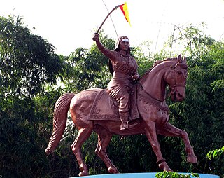
Kittur, historically as Kittoor, is a taluka in the Belgaum district of the Indian state of Karnataka. It was part of Bailhongal taluka but was declared as an independent taluka on 23 October 2012 by the Chief Minister of Karnataka on the inauguration of Kittur Utsav. It is 177th Taluk of Karnataka State. It is a place of historical importance because of the armed rebellion of Kittur Chennamma (1778–1829), Rani of the State of Kittur against the British East India Company, during which a British Commissioner, St John Thackeray was killed.

North Karnataka is a geographical region in Deccan plateau from 300 to 730 metres elevation that constitutes the region of the Karnataka state in India. It is drained by the Krishna River and its tributaries the Bhima, Ghataprabha, Malaprabha, and Tungabhadra. North Karnataka lies within the Deccan thorn scrub forests ecoregion, which extends north into eastern Maharashtra. Most parts of the region has black fertile soil ideal for agriculture.
Hukkeri is a Town Municipal Council and taluka in Belgaum district in the Indian state of Karnataka. Archeological studies reveal that the name Hukkeri is supposed to have been derived from the word Huvinakeri which means Street of Flowers. During Adil Shahi times, roses of good quality were grown here and were sent to Bijapur.
Inchal is a village in the southern state of Karnataka, India. It is located in the Saundatti taluk of Belgaum district in Karnataka.
Itagi is a village in the southern state of Karnataka, India. It is located in the Khanapur taluk of Belgaum district in Karnataka.

M. K. Hubli is a village in the southern state of Karnataka, India. It is located in the Kittur taluk of Belgaum district in Karnataka. M K Hubballi's full form is Mugut Khan Hubballi
Garag is a village in the northern part of Karnataka of India. India. It is located in the Dharwad taluk of Dharwad district in Karnataka.
Kalas is a village in the southern state of Karnataka, India. It is located in the Kundgol taluk of Dharwad district in Karnataka. This is the native place of Guru Govindabhatta, who is the guru of Santha Shishunal Sharif. Today we can find Samadhi of Guru Govindabhatta here. His aradhana takes place every year during summer.
Narendra is a village in the southern state of Karnataka, India. It is located in the Dharwad taluk of Dharwad district in Karnataka.
Shelawadi or Shelavadi is a panchayat town in the southern state of Karnataka, India. It is located in the Navalgund taluk of Dharwad district in Karnataka.
Badachi is a village in Belgaum district in the southern state of Karnataka, India. It is located in Athani Taluka of Belgaum District, near Bijapur -Athani Highway. Maashahibi Darga is situated in the village managed by native Mulla(s) .Allabax S MULLA, Peeralal s mulla, Badashahlal d mulla and every year Maashahibi and Shakarbashah Uras is happen in April or may month,
Diggewadi is a village in Raybag taluk in Belgaum Panchayat in the southern state of Karnataka, India. The official language of Diggewadi is Kannada.
Dodwad is a village in Belgaum district in the southern state of Karnataka, India.
Kakamari is a village in Belgaum district in the southwestern state of Karnataka, India. It belongs to Belgaum Division. It is located 164 km towards North from District headquarters Belgaum. 35 km from Athni. 583 km from State capital Bangalore
Yadoga is a village in Uttar kannada district in the state of Karnataka, India.
Sangolli is a village in Bailahongal taluk of Belgaum district Indian State of Karnataka, India. This is the birthplace of prominent warrior, Rayanna, from Karnataka, India. He was the army chief of the Kingdom of Kittur ruled at the time by Rani Chennamma and fought the British East India Company till his death. His life was the subject of the 2012 Kannada film Sangolli Rayanna.
Kyarakoppa is a small village in the taluk of Kittur of Belgaum district in North Karnataka, India. About 100 families, with total population of around 500 people, live in this village. This tiny village is surrounded by streams and the Malaprabha River. It comes under Devarashigihalli Village Panchayat and Marganakoppa as revenue village. This village is located around 40 km from Belgaum district headquarters to its south and around 17 km from Kittur taluk headquarters to its north west. 475 km from State capital Bangalore.