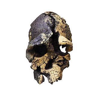
Kenyanthropus is a genus of extinct hominin identified from the Lomekwi site by Lake Turkana, Kenya, dated to 3.3 to 3.2 million years ago during the Middle Pliocene. It contains one species, K. platyops, but may also include the 2 million year old Homo rudolfensis, or K. rudolfensis. Before its naming in 2001, Australopithecus afarensis was widely regarded as the only australopithecine to exist during the Middle Pliocene, but Kenyanthropus evinces a greater diversity than once acknowledged. Kenyanthropus is most recognisable by an unusually flat face and small teeth for such an early hominin, with values on the extremes or beyond the range of variation for australopithecines in regard to these features. Multiple australopithecine species may have coexisted by foraging for different food items, which may be reason why these apes anatomically differ in features related to chewing.
Lake Baringo is, after Lake Turkana, the most northern of the Kenyan Rift Valley lakes, with a surface area of 130 square kilometres (50 sq mi) and an elevation of 970 metres (3,180 ft). The lake is fed by several rivers: the Molo, Perkerra and Ol Arabel. It has no obvious outlet; the waters are assumed to seep through lake sediments into the faulted volcanic bedrock. It is one of the two freshwater lakes in the Rift Valley in Kenya, the other being Lake Naivasha.

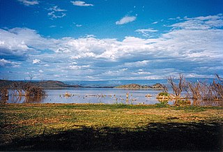
Lake Turkana is a saline lake in the Kenyan Rift Valley, in northern Kenya, with its far northern end crossing into Ethiopia. It is the world's largest permanent desert lake and the world's largest alkaline lake. By volume it is the world's fourth-largest salt lake after the Caspian Sea, Issyk-Kul, and Lake Van, and among all lakes it ranks 24th.

Paranthropus aethiopicus is an extinct species of robust australopithecine from the Late Pliocene to Early Pleistocene of East Africa about 2.7–2.3 million years ago. However, it is much debated whether or not Paranthropus is an invalid grouping and is synonymous with Australopithecus, so the species is also often classified as Australopithecus aethiopicus. Whatever the case, it is considered to have been the ancestor of the much more robust P. boisei. It is debated if P. aethiopicus should be subsumed under P. boisei, and the terms P. boisei sensu lato and P. boisei sensu stricto can be used to respectively include and exclude P. aethiopicus from P. boisei.

Meave G. Leakey is a British palaeoanthropologist. She works at Stony Brook University and is co-ordinator of Plio-Pleistocene research at the Turkana Basin Institute. She studies early hominid evolution and has done extensive field research in the Turkana Basin. She has Doctor of Philosophy and Doctor of Science degrees.

The Suguta Valley, also known as the Suguta Mud Flats, is an arid part of the Great Rift Valley in Kenya (Africa), directly south of Lake Turkana.
Sibiloi National Park lies on the northeastern shore of Lake Turkana in northern Kenya. Established in 1973 by the government of Kenya for the protection of wildlife and paleontologist sites there, it covers 1,570 km2 (610 sq mi) and is internationally known for its fossils. It was listed as a UNESCO World Heritage Site in 1997 as a part of Lake Turkana National Parks.

Koobi Fora refers primarily to a region around Koobi Fora Ridge, located on the eastern shore of Lake Turkana in the territory of the nomadic Gabbra people. According to the National Museums of Kenya, the name comes from the Gabbra language:
In the language of the Gabbra people who live near the site, the term Koobi Fora means a place of the commiphora and the source of myrrh...

KNM ER 1813 is a skull of the species Homo habilis. It was discovered in Koobi Fora, Kenya by Kamoya Kimeu in 1973, and is estimated to be 1.9 million years old.
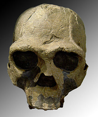
KNM ER 3733 is a fossilized hominid cranium of the extinct hominid Homo ergaster, alternatively referred to as African Homo erectus. It was discovered in 1975 in Koobi Fora, Kenya, right next to Lake Turkana, in a survey led by Richard Leakey, by a field worker called Bernard Ngeneo.

The Bouri Formation is a sequence of sedimentary deposits that is the source of australopithecine and Homo fossils, artifacts, and bones of large mammals with cut marks from butchery with tools by early hominins. It is located in the Middle Awash Valley, in Ethiopia, East Africa, and is a part of the Afar Depression that has provided rich human fossil sites such as Gona and Hadar.
Lokitaung is a settlement in Kenya's Turkana County, a few miles inland of northwest Lake Turkana. Lokitaung is the site of the 36-million year old Lokitaung Basalt lava flows, which lay atop Cretaceous sediments including dinosaur bones. The basalts are over 1 kilometer thick, and approximately 100 kilometers wide.

The greater Turkana Basin in East Africa determines a large endorheic basin, a drainage basin with no outflow centered around the north-southwards directed Gregory Rift system in Kenya and southern Ethiopia. The deepest point of the basin is the endorheic Lake Turkana, a brackish soda lake with a very high ecological productivity in the Gregory Rift.
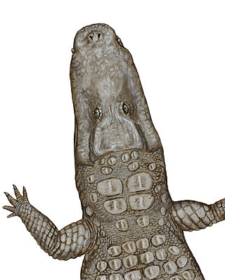
Crocodylus thorbjarnarsoni is an extinct species of crocodile from the Pliocene and Pleistocene of the Turkana Basin in Kenya. It is closely related to the species Crocodylus anthropophagus, which lived during the same time in Tanzania. C. thorbjarnarsoni could be the largest known true crocodile, with the largest skull found indicating a possible total length up to 7.6 m (25 ft). It may have been a predator of early hominins. Crocodylus thorbjarnarsoni was named by Christopher Brochu and Glenn Storrs in 2012 in honor of John Thorbjarnarson, a conservationist who worked to protect endangered crocodilians.

Anna Katherine "Kay" Behrensmeyer is an American taphonomist and paleoecologist. She is a pioneer in the study of the fossil records of terrestrial ecosystems and engages in geological and paleontological field research into the ecological context of human evolution in East Africa. She is Curator of Vertebrate Paleontology in the Department of Paleobiology at the Smithsonian Institution's National Museum of Natural History (NMNH). At the museum, she is co-director of the Evolution of Terrestrial Ecosystems program and an associate of the Human Origins Program.
Loriu Plateau is an elevated Precambrian bedrock exposure at the southwest margin of Lake Turkana in Kenya. The plateau is only seasonally habitable due to aridity and was once home to fauna otherwise rare in Turkana. Loriu is west of and adjacent to the Barrier Volcano at the southernmost portion of Lake Turkana.

Kanapoi is a paleontological site in the Kenyan Rift Valley, to the southwest of Lake Turkana. Fossils were first found at Kanapoi in the 1960s by a Harvard expedition, and later by expeditions from the National Museums of Kenya.

Francis Harold Brown was an American geologist and geochemist who mapped the sedimentary sequence and geology of most of the Turkana Basin in Kenya, east Africa. Brown introduced single-crystal argon-argon and potassium-argon dating into the Turkana Basin, resolving disputes over the age of Kenyanthropus platyops and other fossils.
The KBS Tuff is an ash layer in East African Rift Valley sediments, derived from a volcanic eruption that occurred approximately 1.87 million years ago (Ma). The tuff is widely distributed geographically, and marks a significant transition between water flow and associated environmental conditions around Lake Turkana shortly after 2 Ma.


