
Rift Valley Province of Kenya, bordering Uganda, was one of Kenya's eight provinces, before the Kenyan general election, 2013. Rift Valley Province was the largest and one of the most economically important provinces in Kenya. It was dominated by the Kenya Rift Valley which passes through it and gives the province its name. According to the 2009 Census, the former province covered an area of 182,505.1 square kilometres and would have had a population of 10,006,805, making it the largest and most populous province in the country. The bulk of the provincial population inhabited a strip between former Nairobi and Nyanza Province. The capital was the town of Nakuru.

These lists cover volcanoes by type and by location.

Mount Elgon is an extinct shield volcano on the border of Uganda and Kenya, north of Kisumu and west of Kitale. The mountain's highest point, named "Wagagai", is located entirely within Uganda. Although there is no verifiable evidence of its earliest volcanic activity, geologists estimate that Mount Elgon is at least 24 million years old, making it the oldest extinct volcano in East Africa.
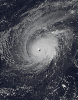
Typhoon Paka, known in the Philippines as Typhoon Rubing, was the last tropical cyclone of the 1997 Pacific hurricane and typhoon season, and was among the strongest Pacific typhoons in the month of December. Paka, which is the Hawaiian name for Pat, developed on November 28 from a trough well to the southwest of Hawaii. The storm tracked generally westward for much of its duration, and on December 7 it crossed into the western Pacific Ocean. Much of its track was characterized by fluctuations in intensity, and on December 10 the cyclone attained typhoon status as it crossed the Marshall Islands. On December 16, Paka struck Guam and Rota with winds of 230 km/h (145 mph), and it strengthened further to reach peak winds on December 18 over open waters as the final super typhoon of the year. Subsequently, it underwent a steady weakening trend, and on December 23 Paka dissipated.
Paka is a coastal town facing the South China Sea in the state of Terengganu in Malaysia. Paka is now a busy town thriving on oil and gas activity near Kerteh. Paka is more popularly known as the home for the largest power station in Malaysia run by the national power company, Tenaga Nasional. Many foreigners and expatriates serving the energy sector live here. Paka is about 100 km to the south of Kuala Terengganu, the capital city of Terengganu. Currently in the end of year 2013, Paka is listed as the third place in Malaysia with the highest living cost. The World Wide Fund for Nature operates a WWF Turtle Sanctuary nearby Paka.

Nová Paka is a town in Jičín District in the Hradec Králové Region of the Czech Republic. It has about 9,000 inhabitants.
Korosi is a shield volcano located in the Gregory Rift at the northern end of Lake Baringo, Kenya.

A complex volcano, also called a compound volcano or a volcanic complex, is a mixed landform consisting of related volcanic centers and their associated lava flows and pyroclastic rock. They may form due to changes in eruptive habit or in the location of the principal vent area on a particular volcano. Stratovolcanoes can also form a large caldera that gets filled in by a lava dome, or else multiple small cinder cones, lava domes and craters may develop on the caldera's rim.

Menengai Crater is a massive shield volcano with one of the biggest calderas in the world, in the Great Rift Valley, Kenya. It is the largest volcano caldera in Kenya and the second largest volcano caldera in Africa. Volcanic formed rich loam soils enrich the adjacent farmland arounds its flanks. The crater is on the floor of the Rift Valley. The volcano formed about 200,000 years ago and the prominent 12 x 8 km caldera formed about 8000 years ago. The caldera floor is covered with numerous post caldera lava flows. The Menengai volcano is considered one of the best-preserved Krakatau-style calderas in the world. Menengai has very little sediment in the caldera which is a thick mass of lava boulders and inaccessible ridges. Volcanic activity continues and a current project under the GDC is at an advanced stage towards geothermal power generation.

Namarunu is a shield volcano located in the Great Rift Valley, Kenya.
Emuruangogolak is an active shield volcano straddling the Gregory Rift in Kenya, in Eastern Africa. It has a 3.5-by-5.0-kilometre caldera on its summit. The last known eruption was a trachyte flow which occurred in 1910. Steam vents and fumarolic activity continues from fissures within the caldera and along the flanks of the volcano. Several maar lakes exist in the rift valley adjacent to the volcano. The volcano's summit is at 1,285 metres (4,216 ft) elevation, and its formation is calculated to have been 38,000 years ago.
The Barrier is an active shield volcano located in the north of Kenya. It is last known to have erupted in 1921.

Paka pri Predgradu is a small settlement northwest of Stari Trg ob Kolpi in southern Slovenia. It belongs to the Municipality of Kočevje. The area is part of the traditional region of Lower Carniola and is now included in the Southeast Slovenia Statistical Region.

The Great Rift Valley is part of an intra-continental ridge system that runs through Kenya from north to south. It is part of the Gregory Rift, the eastern branch of the East African Rift, which starts in Tanzania to the south and continues northward into Ethiopia. It was formed on the "Kenyan Dome" a geographical upwelling created by the interactions of three major tectonics: the Arabian, Nubian, and Somalian plates. In the past, it was seen as part of a "Great Rift Valley" that ran from Madagascar to Syria. Most of the valley falls within the former Rift Valley Province.
Mount Silali is a dormant volcano in the Gregory Rift Valley, near Kapedo, Kenya. Silali is south of the Suguta Valley, which reaches northward to Lake Turkana, and is about 70 kilometres (43 mi) north of Lake Baringo.
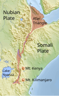
The Gregory Rift is the eastern branch of the East African Rift fracture system. The rift is being caused by the separation of the Somali plate from the Nubian plate, driven by a thermal plume. Although the term is sometimes used in the narrow sense of the Kenyan Rift, the larger definition of the Gregory Rift is the set of faults and grabens extending southward from the Gulf of Aden through Ethiopia and Kenya into Northern Tanzania, passing over the local uplifts of the Ethiopian and Kenyan domes. Ancient fossils of early hominins, the ancestors of humans, have been found in the southern part of the Gregory Rift.
Kuku Paka is a chicken dish with a coconut-based curry and is also called “kuku na nazi”. It has Arabic, Indian and African influences. Kuku in Swahili means chicken. The dish is particularly popular in the East African coast and among the Indian communities living in Kenya, Tanzania and Uganda. Paka in Swahili means to smear, to spread or to apply.
Lake Suguta is a former lake in Africa. It formed in the Suguta Valley, which is part of the East African Rift, south of Lake Turkana during the Holocene African humid period.
