Related Research Articles

The Great Rift Valley is a series of contiguous geographic trenches, approximately 7,000 kilometres (4,300 mi) in total length, that runs from Lebanon in Asia to Mozambique in Southeast Africa. While the name continues in some usages, it is rarely used in geology as it is considered an imprecise merging of separate though related rift and fault systems.
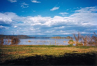
Lake Baringo is, after Lake Turkana, the most northern of the Kenyan Rift Valley lakes, with a surface area of 130 square kilometres (50 sq mi) and an elevation of 970 metres (3,180 ft). The lake is fed by several rivers: the Molo, Perkerra and Ol Arabel. It has no obvious outlet; the waters are assumed to seep through lake sediments into the faulted volcanic bedrock. It is one of the two freshwater lakes in the Rift Valley in Kenya, the other being Lake Naivasha.

Lake Naivasha is a freshwater lake in Kenya, outside the town of Naivasha in Nakuru County, which lies north west of Nairobi. It is part of the Great Rift Valley. The name derives from the local Maasai name Nai'posha, meaning "rough water" because of the sudden storms which can arise.
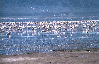
The Rift Valley lakes are a series of lakes in the East African Rift valley that runs through eastern Africa from Ethiopia in the north to Malawi in the south, and includes the African Great Lakes in the south. These include some of the world's oldest lakes, deepest lakes, largest lakes by area, and largest lakes by volume. Many are freshwater ecoregions of great biodiversity, while others are alkaline "soda lakes" supporting highly specialised organisms.

Nakuru County is a county in Kenya. It is County number 32 out of the 47 Kenyan Counties. Nakuru County is a host to Kenya's Forth City – Nakuru City. On 1 December 2021, President Uhuru Kenyatta awarded a City Charter status to Nakuru, ranking it with Nairobi, Mombasa, and Kisumu as the cities in Kenya. With a population of 2,162,202, it is the third most populous county in Kenya after Nairobi County and Kiambu County, in that order. With an area of 7,496.5 km2, it is Kenya's 19th largest county in size. Until 21 August 2010, it formed part of Rift Valley Province.

The Aberdare Range is a 160 km long mountain range of upland, north of Kenya's capital Nairobi with an average elevation of 3,500 metres (11,480 ft). It straddles across the counties of Nyandarua, Nyeri, Muranga, Kiambu and Laikipia. The mountain range is located in west central Kenya, northeast of Naivasha and Gilgil and lies just south of the Equator. The mountain range is called Nyandarua among the Agikuyu people in whose territory this forest and mountain range is located. The name Nyandarua comes from the Kikuyu word rwandarua meaning a drying hide, due to the distinctive fold of its silhouette.

Naivasha is a town in Nakuru County, Kenya, 92.8 km (57.7 mi) north west of Nairobi. From 1969 the population expanded by a factor of 17 times to over 198,000 at the 2019 census.

The Suguta Valley, also known as the Suguta Mud Flats, is an arid part of the Great Rift Valley in Kenya (Africa), directly south of Lake Turkana.
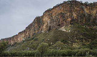
Hell's Gate National Park lies south of Lake Naivasha in Kenya, north west of Nairobi. Hell's Gate National Park is named after a narrow break in the cliffs, once a tributary of a prehistoric lake that fed early humans in the Rift Valley. It was established in 1984. A small national park, it is known for its wide variety of wildlife and for its scenery. This includes the Fischer's Tower and Central Tower columns and Hell's Gate Gorge. The national park is also home to five geothermal power stations at Olkaria. The park is equipped with three basic campsites and includes a Maasai Cultural Center, providing education about the Maasai tribe's culture and traditions.

The Albertine Rift is the western branch of the East African Rift, covering parts of Uganda, the Democratic Republic of the Congo (DRC), Rwanda, Burundi and Tanzania. It extends from the northern end of Lake Albert to the southern end of Lake Tanganyika. The geographical term includes the valley and the surrounding mountains.

Gilgil, Kenya, is a town in Nakuru County, Kenya. The town is located between Naivasha and Nakuru and along the Nairobi - Nakuru highway. It is to the west of the Gilgil River, which flows south to feed Lake Naivasha.
The Lake Naivasha Country Club is located on the opposite shore of Lake Naivasha from the town of Naivasha, Kenya.

Lake Elmenteita is a soda lake, in the Great Rift Valley, about 120 km northwest of Nairobi, Kenya.

The Great Rift Valley is part of an intra-continental ridge system that runs through Kenya from north to south. It is part of the Gregory Rift, the eastern branch of the East African Rift, which starts in Tanzania to the south and continues northward into Ethiopia. It was formed on the "Kenyan Dome" a geographical upwelling created by the interactions of three major tectonics: the Arabian, Nubian, and Somalian plates. In the past, it was seen as part of a "Great Rift Valley" that ran from Madagascar to Syria. Most of the valley falls within the former Rift Valley Province.

The Gregory Rift is the eastern branch of the East African Rift fracture system. The rift is being caused by the separation of the Somali plate from the Nubian plate, driven by a thermal plume. Although the term is sometimes used in the narrow sense of the Kenyan Rift, the larger definition of the Gregory Rift is the set of faults and grabens extending southward from the Gulf of Aden through Ethiopia and Kenya into Northern Tanzania, passing over the local uplifts of the Ethiopian and Kenyan domes. Ancient fossils of early hominins, the ancestors of humans, have been found in the southern part of the Gregory Rift.
The Kinangop Plateau is a region in Kenya that lies between the Kenyan Rift Valley to the west and the Aberdare Range to the east. It takes its name from Kinangop Mountain, which rises in the Aberdares to the east.
The Malewa River rises in the western slopes of the Aberdare Range in Kenya and flows south and west into Lake Naivasha in the Great Rift Valley. Lake Naivasha is an important source of water in a semi-arid environment, and supports export-oriented horticulture and floriculture businesses as well as tourism. Malewa River water quality has deteriorated because of more human activities in the upper catchment. Long-term effects of this on the percentage of rainfall getting into Lake Naivasha are not clear. Possibly in low-rainfall years the percentage will drop because of water abstraction, while in high-rainfall years the percentage will go up because of cultivated soils having a lower water-holding capacity and the introduction of more 100% runoff surfaces like tarmac roads and iron sheets, etc.

The Olkaria Area is a region located immediately to the south of Lake Naivasha in the Great Rift Valley of Kenya, Africa. It is geothermally active and is being used to generate clean electric power. The region has an estimated potential of 2,000 MW. This is almost double the maximum daily electricity peak demand recorded in 2008/2009 for the entire country.
The Turasha River is a major tributary of the Malewa River, which feeds Lake Naivasha in the Great Rift Valley of Kenya.
David M. Harper is an English zoologist specialising in limnology.
References
- ↑ Harper 2003, p. 1.
- 1 2 Harper 2003, p. 19.
- ↑ Harper 2003, p. 16.
- ↑ Lake Naivasha - Birdlife.
- ↑ Vetiver 2009.
- ↑ Gregory 1896, p. 323.