Waseges River

Last updated
Waseges River
Kenya relief location map.jpg
Red pog.svg
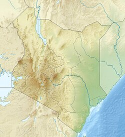
Mouth location in Kenya
Physical characteristics
Source 
  coordinates 0°00′57″S36°13′20″E / 0.015836°S 36.222267°E / -0.015836; 36.222267
Mouth  
  coordinates
0°20′34″N36°04′41″E / 0.342698°N 36.078147°E / 0.342698; 36.078147

The Waseges River (or Sandai River) is a river that rises on the slopes of the Nyandarua Plateau below the Aberdare Range in Kenya. The river flows north, then west and south to enter Lake Bogoria in the Great Rift Valley from the north after passing through a swamp. [1] In 2002 rubies were found in the region of the Waseges River. [2]

Contents

Climate

In its upper reaches the Waseges flows through regions of intensive coffee cultivation where heavy use is made of chemical fertilizers and pesticides. Lower down it flows through bush and scrub used for grazing, and then through very dry bush before entering the lake at its northern end. [3] The river is seasonal, and is the main affluent of the lake. [4] The inertial flow of the river may generate counter-clockwise currents in the lake. [5]

Irrigation scheme

The Waseges is an important source of irrigation water. With rising populations, by 1985 the Tugen people of Sandai were sometimes refusing to allow their neighbors, the Camus people, to use water from the river. [6] The Sandai farmers had been in the habit of cultivating two or three out of six cultivated areas each year. A given area would be farmed for three or four years, then left fallow for up to four years. All the areas are fed by canals from the Waseges, but half the canals will be blocked at any time. Use of the irrigated farm areas involved agreements between the Tugen and Camus people. [7]

An irrigation scheme carried out by the Baringo District Provincial Irrigation Unit (PIU), funded and given technical support by Dutch Aid, aimed to improve the usage of the river waters. The planned irrigation scheme was based on a single large concrete-lined canal feeding just one area. Scheduled for launch in 1983, there were delays due to protests from the local people, and the project was not completed until the 1987/1988 season. The project introduced a less flexible system, created tensions between the Tugen and Camus people, and tensions among the Tugen. [7]

In 2003 the river was illegally diverted for irrigation upstream in the Subukia area, causing it to dry up downstream during a period of drought. The Ministry of Water Management and Development proposed to establish river basin catchment committees and water user associations to manage the use of the river. [8]

Related Research Articles

<span class="mw-page-title-main">Irrigation</span> Agricultural artificial application of water to land

Irrigation is the practice of applying controlled amounts of water to land to help grow crops, landscape plants, and lawns. Irrigation has been a key aspect of agriculture for over 5,000 years and has been developed by many cultures around the world. Irrigation helps to grow crops, maintain landscapes, and revegetate disturbed soils in dry areas and during times of below-average rainfall. In addition to these uses, irrigation is also employed to protect crops from frost, suppress weed growth in grain fields, and prevent soil consolidation. It is also used to cool livestock, reduce dust, dispose of sewage, and support mining operations. Drainage, which involves the removal of surface and sub-surface water from a given location, is often studied in conjunction with irrigation.

<span class="mw-page-title-main">Lake Baringo</span> Freshwater lake in Kenya

Lake Baringo is, after Lake Turkana, the most northern of the Kenyan Rift Valley lakes, with a surface area of 130 square kilometres (50 sq mi) and an elevation of 970 metres (3,180 ft). The lake is fed by several rivers: the Molo, Perkerra and Ol Arabel. It has no obvious outlet; the waters are assumed to seep through lake sediments into the faulted volcanic bedrock. It is one of the two freshwater lakes in the Rift Valley in Kenya, the other being Lake Naivasha.

<span class="mw-page-title-main">Kerio River</span> River

The Kerio River is a river in Turkana County, Kenya. It flows northward into Lake Turkana. It is one of the longest rivers in Kenya, originating near the equator.

<span class="mw-page-title-main">Kura (river)</span> River in the Caucasus region

The Kura is an east-flowing river south of the Greater Caucasus Mountains which drains the southern slopes of the Greater Caucasus east into the Caspian Sea. It also drains the north side of the Lesser Caucasus, while its main tributary, the Aras, drains the south side of those mountains. Starting in northeastern Turkey, the Kura flows through Turkey to Georgia, then to Azerbaijan, where it receives the Aras as a right tributary, and enters the Caspian Sea at Neftçala. The total length of the river is 1,515 kilometres (941 mi).

<span class="mw-page-title-main">Bear River (Great Salt Lake)</span> River in southwestern Wyoming, southeastern Idaho, and northern Utah

The Bear River is the largest tributary of the Great Salt Lake, draining a mountainous area and farming valleys northeast of the lake and southeast of the Snake River Plain. It flows through northeastern Utah, southwestern Wyoming, southeastern Idaho, and back into northern Utah, in the United States. Approximately 350 miles (560 km) long it is the longest river in North America that does not ultimately reach the sea.

<span class="mw-page-title-main">Dujiangyan</span> Ancient irrigation system in Sichuan, China

The Dujiangyan is an ancient irrigation system in Dujiangyan City, Sichuan, China. Originally constructed around 256 BC by the State of Qin as an irrigation and flood control project, it is still in use today. The system's infrastructure develops on the Min River (Minjiang), the longest tributary of the Yangtze. The area is in the west part of the Chengdu Plain, between the Sichuan Basin and the Tibetan Plateau. Originally, the Min would rush down from the Min Mountains and slow down abruptly after reaching the Chengdu Plain, filling the watercourse with silt, thus making the nearby areas extremely prone to floods. King Zhao of Qin commissioned the project, and the construction of the Dujiangyan harnessed the river using a new method of channeling and dividing the water rather than simply damming it. The water management scheme is still in use today to irrigate over 5,300 km2 (2,000 sq mi) of land in the region and has produced comprehensive benefits in flood control, irrigation, water transport and general water consumption. Begun over 2,250 years ago, it now irrigates 668,700 hectares of farmland. The Dujiangyan, the Zhengguo Canal in Shaanxi and the Lingqu Canal in Guangxi are collectively known as the "three great hydraulic engineering projects of the Qin."

<span class="mw-page-title-main">Lake Bogoria</span>

Lake Bogoria is a saline, alkaline lake that lies in a volcanic region in a half-graben basin south of Lake Baringo, Kenya, a little north of the equator. Lake Bogoria, like Lake Nakuru, Lake Elementeita, and Lake Magadi further south in the Rift Valley, and Lake Logipi to the north, is home at times to one of the world's largest populations of lesser flamingos. The lake is a Ramsar site and Lake Bogoria National Reserve has been a protected National Reserve since November 29, 1973. Lake Bogoria is shallow, and is about 34 km long by 3.5 km wide, with a drainage basin of 700 km2. It is Located in Baringo County.

<span class="mw-page-title-main">Kapthurin Formation</span> Pleistocene geological formation in East Africa

The Kapthurin Formation is a series of Middle Pleistocene sediments associated with the East African Rift Valley. Part of the East African Rift System, it is also an important archaeological site in the study of early humans who occupied the area and left stone tools and animal bones behind. It outcrops in Kenya west of Lake Bogoria and northwest of Lake Baringo in the Kenya Rift Valley, exposed on the surface in a 150 km2 (58 sq mi) area. It also outcrops in portions of the Tugen Hills farther east. The ~125 metres (410 ft) of sediment that comprises the Kapthurin formation represents more than 600,000 years of depositional history. Clastic sediments, tuffs, and carbonate beds, in the Kapthurin give information on past river and lake environments. Additionally, intercalated tuffs and extrusive igneous rocks associated with Rift Valley volcanic activity have allowed for multiple argon–argon dating studies. The high resolution dating enables archaeological studies regarding changing hominin behavior. The Kapthurin Formation has been used to study the Acheulian-Middle Stone Age transition.

<span class="mw-page-title-main">Ewaso Ng'iro</span> River in Kenya

Ewaso Ng'iro, also called Ewaso Nyiro, is a river in Kenya which rises on the west side of Mount Kenya and flows north then east and finally south-east, passing through Somalia where it joins the Jubba River. The river's name is derived from the local community's language, and means river of brown or muddy water. Downstream, the intermittent stream in Somalia is also called Lagh Dera.

<span class="mw-page-title-main">Kerio Valley</span>

Kerio Valley lies between the Tugen Hills and the Elgeyo Escarpment in Kenya. It sits at an elevation of 1,000 meters in the Great Rift Valley.

Water resources management in modern Egypt, is a complex process that involves multiple stakeholders who use water for irrigation, municipal and industrial water supply, hydropower generation and navigation. In addition, the waters of the Nile support aquatic ecosystems that are threatened by abstraction and pollution. Egypt also has substantial fossil groundwater resources in the Western Desert.

<span class="mw-page-title-main">Bakolori Dam</span> Dam in Nigeria

The Bakolori Dam is in Sokoto State in northwest Nigeria. It was completed in 1978 and its reservoir filled by 1981. It is a major reservoir on the Sokoto River, a tributary of the Rima River, which in turn feeds the Niger River. Water from the dam supplies the Bakolori Irrigation Project.

<span class="mw-page-title-main">Great Rift Valley, Kenya</span> Part of an intra-continental ridge system that runs through Kenya

The Great Rift Valley is part of an intra-continental ridge system that runs through Kenya from north to south. It is part of the Gregory Rift, the eastern branch of the East African Rift, which starts in Tanzania to the south and continues northward into Ethiopia. It was formed on the "Kenyan Dome" a geographical upwelling created by the interactions of three major tectonics: the Arabian, Nubian, and Somalian plates. In the past, it was seen as part of a "Great Rift Valley" that ran from Madagascar to Syria. Most of the valley falls within the former Rift Valley Province.

<span class="mw-page-title-main">Gregory Rift</span>

The Gregory Rift is the eastern branch of the East African Rift fracture system. The rift is being caused by the separation of the Somali plate from the Nubian plate, driven by a thermal plume. Although the term is sometimes used in the narrow sense of the Kenyan Rift, the larger definition of the Gregory Rift is the set of faults and grabens extending southward from the Gulf of Aden through Ethiopia and Kenya into Northern Tanzania, passing over the local uplifts of the Ethiopian and Kenyan domes. Ancient fossils of early hominins, the ancestors of humans, have been found in the southern part of the Gregory Rift.

<span class="mw-page-title-main">Lake Bogoria National Reserve</span>

Lake Bogoria National Reserve is in the Great Rift Valley, Kenya, covering Lake Bogoria and the land immediately surrounding the lake. It is administered by the Kenya Wildlife Service.

<span class="mw-page-title-main">Southern Ewaso Ng'iro</span> River in Kenya

The Southern Ewaso Ng'iro is a river in the Great Rift Valley in Kenya. It plays an important role in the ecology of Lake Natron, the main regular breeding site for near-threatened lesser flamingos. Changes to land use in the river's headwaters or in the marshes before the river enters the lake could have a serious impact on this species.

<span class="mw-page-title-main">Perkerra River</span> River in Kenya

The Perkerra River is a river in the Great Rift Valley in Kenya that feeds the freshwater Lake Baringo. It is the only perennial river in the arid and semi-arid lands of the Baringo County. The Perkerra river supplies water to the Perkerra Irrigation Scheme in the Jemps flats near Marigat Township, just south of the lake.

Ol Arabel is a river in the Great Rift Valley of Kenya that feeds Lake Baringo. It gives its name to a forest covering its headwaters and to a region.

<span class="mw-page-title-main">Yala River</span> River in Kenya

The Yala River is a river in western Kenya, a tributary of Lake Victoria. It generally flows fast over a rocky bed through a wide valley before joining the Nzoia River to form the Yala Swamp on the border of Lake Victoria. The land along its course is mostly cultivated or used for grazing, with relatively few remnants of the original forest. Soil erosion is visible throughout the river basin, particularly in the lower parts. Projects are underway to exploit the river for hydroelectricity.

References

  1. Hughes & Hughes 1992, p. 189.
  2. Ruby.
  3. Lake Bogoria UNESCO.
  4. Anadón, Cabrera & Kelts 1991, p. 177.
  5. Anadón, Cabrera & Kelts 1991, p. 183.
  6. Little 1992, p. 137.
  7. 1 2 Little 1992, p. 167-168.
  8. Karua 2003, p. 1335.

Sources