
Lake Turkana is a saline lake in the Kenyan Rift Valley, in northern Kenya, with its far northern end crossing into Ethiopia. It is the world's largest permanent desert lake and the world's largest alkaline lake. By volume it is the world's fourth-largest salt lake after the Caspian Sea, Issyk-Kul, and Lake Van, and among all lakes it ranks 24th.

The Turkana are a Nilotic people native to the Turkana County in northwest Kenya, a semi-arid climate region bordering Lake Turkana in the east, Pokot, Rendille and Samburu people to the south, Uganda to the west, to the South Sudan and Ethiopia to the north.

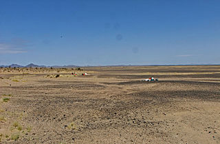
Koobi Fora refers primarily to a region around Koobi Fora Ridge, located on the eastern shore of Lake Turkana in the territory of the nomadic Gabbra people. According to the National Museums of Kenya, the name comes from the Gabbra language:
In the language of the Gabbra people who live near the site, the term Koobi Fora means a place of the commiphora and the source of myrrh...
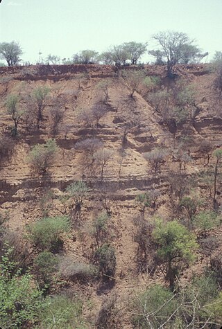
The Kapthurin Formation is a series of Middle Pleistocene sediments associated with the East African Rift Valley. Part of the East African Rift System, it is also an important archaeological site in the study of early humans who occupied the area and left stone tools and animal bones behind. It outcrops in Kenya west of Lake Bogoria and northwest of Lake Baringo in the Kenya Rift Valley, exposed on the surface in a 150 km2 (58 sq mi) area. It also outcrops in portions of the Tugen Hills farther east. The ~125 metres (410 ft) of sediment that comprises the Kapthurin formation represents more than 600,000 years of depositional history. Clastic sediments, tuffs, and carbonate beds, in the Kapthurin give information on past river and lake environments. Additionally, intercalated tuffs and extrusive igneous rocks associated with Rift Valley volcanic activity have allowed for multiple argon–argon dating studies. The high resolution dating enables archaeological studies regarding changing hominin behavior. The Kapthurin Formation has been used to study the Acheulian-Middle Stone Age transition.

Turkana County is a county in the former Rift Valley Province of Kenya. It is Kenya's largest county by land area of 98,597.8km2 followed by Marsabit County with an area of 71,597.8km2. It is bordered by the countries of Uganda to the west; South Sudan and Ethiopia, including the disputed Ilemi Triangle, to the north and northeast; and Lake Turkana to the east. To the south and east, neighbouring counties in Kenya are West Pokot, Baringo and Samburu Counties, while Marsabit County is on the opposite shore of Lake Turkana. Turkana's capital and largest town is Lodwar. The county had a population of 926,976 at the 2019 census.
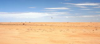
The Chalbi Desert is a small desert in northern Kenya near the border with Ethiopia. It is east of Lake Turkana and contains North Horr. Marsabit is the closest major urban center.
The Lapurr Sandstone, also spelled Lapur Sandstone, previously considered part of the informal "Turkana Grits", is a geological formation in Kenya. It is the oldest unit in the Turkana Basin. The strata date back to the Late Cretaceous, likely Campanian to Maastrichtian, based on palynology and the presence of dyrosaurs and mosasaurs, the upper part of the unit likely extends into the Palaeogene, based on zircon dating. It predominantly consists of fine-coarse arkosic sandstone, which has been interpreted as either been deposited in fluvial or shallow marine conditions. Dinosaur remains among other vertebrates have been recovered from it around Lokitaung Gorge, though these mostly consist of heavily abraded, isolated bones of robust morphology like sauropod limb bones and caudal vertebrae.

Lothagam is a geological formation located in Kenya, near the southwestern shores of Lake Turkana, 55 km (34 mi) from Kanapoi. It is located between the Kerio and Lomunyenkuparet Rivers on an uplifted fault block.
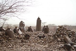
The Nasura Pillar Site, registered as GcJh3 and also known as Namoratunga II, is an archaeological site on the west side of Lake Turkana in Kenya dating to the Pastoral Neolithic. Namoratunga means "people of stone" in the Turkana language. The site was originally believed to have been created around 300 BC, but recent excavations have yielded an older radiocarbon sample dating to 2398 +/- 44 years BC.
Lokori is a Turkana settlement in Kenya's North Eastern Province, adjacent to the Kerio River. The settlement's inhabitants are traditionally pastoralists. Lokori is home to a number of prehistoric Namoratunga rock art and burial sites.

The greater Turkana Basin in East Africa determines a large endorheic basin, a drainage basin with no outflow centered around the north-southwards directed Gregory Rift system in Kenya and southern Ethiopia. The deepest point of the basin is the endorheic Lake Turkana, a brackish soda lake with a very high ecological productivity in the Gregory Rift.

Anna Katherine "Kay" Behrensmeyer is an American taphonomist and paleoecologist. She is a pioneer in the study of the fossil records of terrestrial ecosystems and engages in geological and paleontological field research into the ecological context of human evolution in East Africa. She is Curator of Vertebrate Paleontology in the Department of Paleobiology at the Smithsonian Institution's National Museum of Natural History (NMNH). At the museum, she is co-director of the Evolution of Terrestrial Ecosystems program and an associate of the Human Origins Program.
The Pastoral Neolithic refers to a period in Africa's prehistory, specifically Tanzania and Kenya, marking the beginning of food production, livestock domestication, and pottery use in the region following the Later Stone Age. The exact dates of this time period remain inexact, but early Pastoral Neolithic sites support the beginning of herding by 5000 BP. In contrast to the Neolithic in other parts of the world, which saw the development of farming societies, the first form of African food production was nomadic pastoralism, or ways of life centered on the herding and management of livestock. The shift from hunting to food production relied on livestock that had been domesticated outside of East Africa, especially North Africa. This period marks the emergence of the forms of pastoralism that are still present. The reliance on livestock herding marks the deviation from hunting-gathering but precedes major agricultural development. The exact movement tendencies of Neolithic pastoralists are not completely understood.

Kanapoi is a paleontological site in the Kenyan Rift Valley, to the southwest of Lake Turkana. Fossils were first found at Kanapoi in the 1960s by a Harvard expedition, and later by expeditions from the National Museums of Kenya.

Karsa is a basalt geological formation, archaeological site, and watering hole in Turkana County, Kenya, on the southeast margin of Lake Turkana. Karsa volcanic flows lie at the base of important sedimentary formations in the Turkana Basin and are an example of columnar jointed basalt.
Nataruk in Turkana County, Kenya, is the site of an archaeological investigation which uncovered the remains of 27 people. It dates between 9,500 and 10,500 BP. The remains have garnered wide media attention for possible bioarchaeological evidence of interpersonal violence, i.e. prehistoric warfare.
Sonia Harmand is a French archaeologist who studies Early Stone Age archaeology and the evolution of stone tool making. She received her undergraduate degree from the University of Paris where she was associated with the "Prehistory and Technology" research unit, which was well known in the field of stone tool analysis. Harmand earned a PhD from Paris Nanterre University, and is a research associate at CNRS, which is the largest French governmental research organization, and Europe's largest fundamental science agency. She worked as a Research Scientist at CNRS for four years before joining Stony Brook University in New York as an associate professor. In 2016 she was named one of the '50 Most Influential French' by the French edition of Vanity Fair magazine, ranked 32nd place.
Friends of Lake Turkana (FoLT) is a nonprofit organization in Kenya that was founded in 2007 by Kenyan environmentalist Ikal Angelei. The organization has worked to stop the construction of the Ethiopian Gilgel Gibe III Dam on the Omo River, Lake Turkana's primary source of water. Due to FoLT and other partner's advocacy work on saving Lake Turkana, the Lake was added to the list of world Heritage sites in Danger by UNESSCO in June 2018.

The Lothagam North Pillar Site, registered as GeJi9, is an archaeological site at Lothagam on the west side of Lake Turkana in Kenya dating to the Pastoral Neolithic and the Holocene. It is a communal cemetery, built between 3000 BCE and 2300 BCE by the region's earliest herders as rainfall in the area decreased and Lake Turkana receded. It is thought to be eastern Africa's largest and earliest monumental cemetery.

The Tobong'u Lore, known in English as the Lake Turkana Cultural Festival, is a celebration of indigenous culture held every spring in Turkana, northern Kenya. The festival is hosted by a number of indigenous communities adjacent to the lake, and is meant to promote peace, cultural exchange, and tourism. The El Molo people host the festival in Loiyangalani every June, and the Turkana people host the festival in Lodwar in April. The Tobong'u Lore is considered among the largest of cultural festivals in Kenya, and has become a venue for appearances by prominent Kenyan politicians.

