
Landing is the last part of a flight, where a flying animal, aircraft, or spacecraft returns to the ground. When the flying object returns to water, the process is called alighting, although it is commonly called "landing", "touchdown" or "splashdown" as well. A normal aircraft flight would include several parts of flight including taxi, takeoff, climb, cruise, descent and landing.
In aviation, a go-around is an aborted landing of an aircraft that is on final approach or has already touched down. A go-around can either be initiated by the pilot flying or requested by air traffic control for various reasons, such as an unstabilized approach or an obstruction on the runway. Go arounds are also referred to as overshoots in some cases, a name also given to running off the end of the runway.

Akron–Canton Airport is a commercial airport in the city of Green, in southern Summit County, Ohio. The airport is located about 14 miles (23 km) southeast of Akron and 10 miles (16 km) northwest of Canton. It is jointly operated by Summit County and Stark County. The airport is a "reliever" airport for Northeast Ohio and markets itself as "A better way to go", emphasizing the ease of travel in comparison to Cleveland Hopkins International Airport. Just under 90% of its traffic is general aviation. It is included in the Federal Aviation Administration (FAA) National Plan of Integrated Airport Systems for 2019–2023, in which it is categorized as a small-hub primary commercial service facility.

Republic Airport is a regional airport in East Farmingdale, New York, located one mile east of Farmingdale village limits.

Blue Grass Airport is a public airport in Fayette County, Kentucky, United States, 6 miles west of downtown Lexington. Located among horse farms and situated directly across from Keeneland Race Course, Blue Grass Airport is the primary airport serving central and eastern Kentucky. More than 1.3 million passengers depart or arrive annually at Blue Grass Airport. In 2017, the airport served 1,316,847 passengers via four major airline carriers: Allegiant Air, American Airlines, Delta Air Lines, and United Airlines.
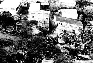
American Airlines Flight 625, a Boeing 727-100, crashed at St. Thomas, U.S. Virgin Islands on April 27, 1976, while on a domestic scheduled passenger flight originating at T. F. Green Airport in Rhode Island and ending at Saint Thomas, United States Virgin Islands, with an intermediate stop at John F. Kennedy International Airport. 37 out of the 88 passengers on board died in the accident.

Cuyahoga County Airport, also known as Robert D. Shea Field, is a public use airport in northeastern Cuyahoga County, Ohio, United States. Owned and operated by Cuyahoga County since 1946, it also serves Lake County and Geauga County. The airport is located 10 nautical miles east of downtown Cleveland and sits on the border of three cities: Highland Heights, Richmond Heights and Willoughby Hills. It is included in the National Plan of Integrated Airport Systems for 2011–2015, which categorized it as a general aviation reliever airport for Cleveland Hopkins International Airport.
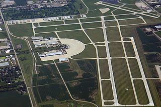
DuPage Airport is a general aviation airport located 29 miles (47 km) west of downtown Chicago in West Chicago, DuPage County, Illinois, United States. It is owned and operated by the DuPage Airport Authority, which is an independent government body established by law by the State of Illinois. It also serves as a relief airport for O'Hare International Airport and Chicago Midway International Airport, both in nearby Chicago.

Lufthansa Flight 2904 was an Airbus A320-200 flying from Frankfurt, Germany to Warsaw, Poland that overran the runway at Okęcie International Airport on 14 September 1993.

Butler County Regional Airport is a publicly owned, public use airport at 2820 Airport Road East in Hamilton, Ohio. It is owned by the Butler County Board of Commissioners.
Lake County Executive Airport, formerly Lost Nation Airport, is a public use airport in Lake County, Ohio, United States. Located approximately 3 miles (5 km) north-northeast of the central business district of the City of Willoughby, it was owned and operated by that city until October 8, 2014, when it was transferred to Lake County and the Lake County Port and Economic Development Authority. The airport's name was changed from Lost Nation Airport to Lake County Executive Airport, alternately "Lake County Executive Airport at Lost Nation Field," in March 2020.
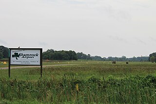
Brooklyn Airport, also known as Shamrock Field, is a privately-owned, public-use airport located in Brooklyn, Michigan, United States. It is at an elevation of 987 feet.
Jack Barstow Airport, also known as Jack Barstow Municipal Airport, is a city-owned, public-use airport located three nautical miles (6 km) northwest of the central business district of Midland, a city in Midland County, Michigan, United States. It is included in the Federal Aviation Administration (FAA) National Plan of Integrated Airport Systems for 2017–2021, in which it is categorized as a local general aviation facility.

Baramati Airport is located in Baramati, Pune district of Maharashtra state in India. This airstrip was constructed by MIDC in 1996, at a distance of 12 km from Baramati city/ Baramati railway station. It is currently being used for general aviation and pilot training.

The 1965 Skyways Coach-Air Avro 748 crash occurred on 11 July 1965 when Avro 748-101 Series 1 G-ARMV, flown during a scheduled international passenger flight from Beauvais Airport, Oise, France, crashed on landing at its intended destination of Lympne Airport, Kent, United Kingdom. The accident was due to the grass runway being unable to support the weight of the aircraft during a heavy landing. This caused the nose wheels to dig in and the aircraft to overturn, losing both wings and the starboard tailplane in the process. All 52 people on board survived. This was the first accident involving the Avro 748/HS 748 that resulted in a write-off. A concrete runway was later installed at Lympne.
Wedderburn Airstrip is an unlicensed private airfield located in Wedderburn, New South Wales, an outer rural suburb of Sydney, Australia. The airfield caters to recreational aircraft owners and pilots, all of whom are members of the New South Wales Sport Aircraft Club.
Coldstream Airport is a small Australian regional airfield located in the township of Coldstream in Greater Melbourne, Victoria.
Pinjore Airfield is being operated as a pilot training institute owned and operated by Haryana Institute of Civil Aviation (HICA) under guidance of Civil Aviation Department, Government of Haryana. The flying school is spread over an area of 96 acres and is located on Pinjore - Baddi main highway near the cities of Kalka and Pinjore in the Panchkula district of the Indian state of Haryana.
Weltzien Skypark is a privately owned, public use airport located 3 miles west of Wadsworth, Ohio in Medina County. The airpark sits on 26 acres at an elevation of 1210 feet.
