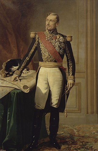
Armand-Jacques Leroy de Saint-Arnaud was a French soldier and Marshal of France. He served as French Minister of War until the Crimean War when he became Commander-in-chief of the army of the East.

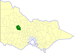
The Shire of Northern Grampians is a local government area in the Wimmera region of Victoria, Australia, located in the western part of the state. It covers an area of 5,730 square kilometres (2,210 sq mi) and in June 2018 had a population of 11,431, having fallen from 12,087 in 2008. It includes the towns of Stawell, St Arnaud, Great Western, Marnoo, Glenorchy, Stuart Mill, Navarre and the tourist town of Halls Gap. It was formed in 1995 from the amalgamation of the City of Stawell, Town of St Arnaud, Shire of Stawell, Shire of Kara Kara and parts of the Shire of Wimmera, Shire of Dunmunkle and Shire of Donald.
Saint Arnaud, the French for Saint Arnold, is the name of the following places :

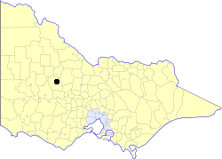
St Arnaud is a town in the Wimmera region of Victoria, Australia, 244 kilometres north west of the capital Melbourne. It is in the Shire of Northern Grampians local government area. At the 2021 census, St Arnaud had a population of 2,318.
Bendigo Airport, is located in East Bendigo just north of Bendigo, Victoria, Australia, just off the Midland Highway. The airport is located approximately 10 minutes away from the Bendigo CBD.
Hamilton Airport is located 6.5 nautical miles north of Hamilton, Victoria, Australia. The airport is about 300 km (190 mi) west of Melbourne. Sharp Airlines was established at the airport and despite cancelling scheduled service in December 2014, retains a flying school at Hamilton. The airport is also home to the Hamilton Aero Club. The airport is operated by the Southern Grampians Shire Council.
Warrnambool Airport is located 6 nautical miles northwest of Warrnambool, Victoria in Australia. Avalon Air Services operates training activities from the airport. HEMS 4, an AgustaWestland AW139, of Air Ambulance Victoria is based at the airport.

The Anglican Diocese of Bendigo is a diocese of the Anglican Church of Australia. It is situated in the Bendigo region of the state of Victoria, Australia. Its geographic remit extends from that part of Victoria that lies north of the Great Dividing Range and west of the Goulburn River to the border with the state of South Australia. The diocesan cathedral is St Paul's Cathedral, Bendigo. The diocese was separated from the Diocese of Melbourne in 1902, with Henry Archdall Langley installed as the first bishop. The current bishop, Matt Brain, was installed on 17 February 2018.
Victoria River Downs Airport is an airport in Victoria River in the Northern Territory of Australia which serves the Victoria River Downs Station.
ABC Central Victoria is an ABC Local Radio station based in Bendigo, Victoria. The station opened in January 1993 and covers Bendigo, Echuca, St Arnaud and Kyneton.

Wimmera Highway is a 345 kilometre highway that connects the towns of Marong, Victoria and Naracoorte, South Australia, through the major junctions of Sunraysia Highway, Henty Highway and Western Highway.

The Shire of Karkarooc was a local government area in northwestern Victoria, Australia. The shire covered an area of 3,719 square kilometres (1,435.9 sq mi), and existed from 1896 until 1995.
The Shire of Kara Kara was a local government area about 240 kilometres (149 mi) northwest of Melbourne, the state capital of Victoria, Australia. The shire covered an area of 2,292.79 square kilometres (885.3 sq mi), and existed from 1861 until 1995.
The Town of St Arnaud was a local government area about 240 kilometres (149 mi) northwest of Melbourne, the state capital of Victoria, Australia. The town covered an area of 25.92 square kilometres (10.0 sq mi), and existed from 1861 until 1994. Its area was surrounded by the Shire of Kara Kara.

The County of Kara Kara is one of the 37 counties of Victoria which are part of the cadastral divisions of Australia, used for land titles. The northern boundary of the county is at 36°S. At the north its western boundary is 143°E. Larger towns include St Arnaud and Donald. The County was proclaimed in 1871 together with the other counties of the Wimmera Land District.

The Anglican Diocese of St Arnaud was a diocese of the Church of England in Australia, in the Mallee and Wimmera regions of north-west Victoria. It was created in 1926 out of the Diocese of Ballarat and named after the town of St Arnaud. In 1976 it was amalgamated into the Diocese of Bendigo.
Allen Ernest Winter was an Australia Anglican bishop. He was the long-serving second bishop of the former Diocese of St Arnaud in north-west Victoria.

The Kara Kara National Park is a national park located in the Wimmera/Goldfields region of Victoria, Australia. The 13,990-hectare (34,600-acre) national park is situated approximately 190 kilometres (120 mi) north-west of Melbourne, west of the Sunraysia Highway, and to the south of the town of St Arnaud.
The Avon River, an inland intermittent river of the Wimmera catchment, located in the Grampians and Wimmera regions of the Australian state of Victoria. Rising on the northern slopes of the Great Dividing Range, the Avon River flows north-westerly to reach its confluence with the Richardson River. The rivers of the Wimmera catchment drain into a series of ephemeral lakes that, whilst they do not directly empty into a defined watercourse, form part of the Murray River catchment of the Murray-Darling basin.
