
This is a list of wadis in Libya . This list is arranged by region from west to east, with respective tributaries indented under each larger stream's name.


This is a list of wadis in Libya . This list is arranged by region from west to east, with respective tributaries indented under each larger stream's name.

The geography of Egypt relates to two regions: North Africa and West Asia.

Libya is the fourth largest country in Africa and the sixteenth largest country in the world. It is on the Mediterranean with Egypt to the east, Tunisia to the northwest, Algeria to the west, Niger and Chad to the south, and Sudan to the southeast. Although the oil discoveries of the 1960s have brought immense wealth, at the time of its independence it was an extremely poor desert state whose only important physical asset appeared to be its strategic location at the midpoint of Africa's northern rim.

The Jordan River or River Jordan, also known as Nahr Al-Sharieat, is a 251-kilometre-long (156 mi) river in the Middle East that flows roughly north to south through the Sea of Galilee and on to the Dead Sea. Jordan and the Golan Heights border the river to the east, while the West Bank and Israel lie to its west. Both Jordan and the West Bank take their names from the river.

This is a comprehensive list of rivers, organized primarily by continent and country.

The Khabur River is the largest perennial tributary to the Euphrates in Syria. Although the Khabur originates in Turkey, the karstic springs around Ras al-Ayn are the river's main source of water. Several important wadis join the Khabur north of Al-Hasakah, together creating what is known as the Khabur Triangle, or Upper Khabur area. From north to south, annual rainfall in the Khabur basin decreases from over 400 mm to less than 200 mm, making the river a vital water source for agriculture throughout history. The Khabur joins the Euphrates near the town of Busayrah.

In Libya there are currently 106 districts, second level administrative subdivisions known in Arabic as baladiyat. The number has varied since 2013 between 99 and 108. The first level administrative divisions in Libya are currently the governorates (muhafazat), which have yet to be formally deliniated, but which were originally tripartite as: Tripolitania in the northwest, Cyrenaica in the east, and Fezzan in the southwest; and later divided into ten governorates.

Sabha is one of the districts of Libya, situated near the center of the country in the Fezzan region. The city of Sabha serves as its capital. The district shares borders with the following districts: Wadi Al Shatii to the north, Al Jufrah to the east, Murzuq to the south, and Wadi Al Hayaa to the west.

Fezzan is the southwestern region of modern Libya. It is largely desert, but broken by mountains, uplands, and dry river valleys (wadis) in the north, where oases enable ancient towns and villages to survive deep in the otherwise inhospitable Sahara Desert. The term originally applied to the land beyond the coastal strip of Africa proconsularis, including the Nafusa and extending west of modern Libya over Ouargla and Illizi. As these Berber areas came to be associated with the regions of Tripoli, Cirta or Algiers, the name was increasingly applied to the arid areas south of Tripolitania.

Cherith, Kerith, or sometimes Chorath, is the name of a wadi, or intermittent seasonal stream mentioned in the Hebrew Bible. The prophet Elijah hid himself on the banks of the Cherith and was fed by ravens during the early part of the three years' drought which he announced to King Ahab.

Derna is a port city in eastern Libya. With a population of around 85,000 to 90,000, Derna was once the seat of one of the wealthiest provinces among the Barbary States. The city is now the administrative capital of Derna District, which covers a much smaller area than the old province. Among Libyan cities, Derna has a unique location and physical environment, as it lies between Jebel Akhdar, the Mediterranean Sea, and the desert. The city is also home to people of many different backgrounds.

Al Wahat or The Oases, occasionally spelt Al Wahad or Al Wahah is one of the districts of Libya. Its capital and largest city is Ajdabiya. The district is home to much of Libya's petroleum extraction economic activity.

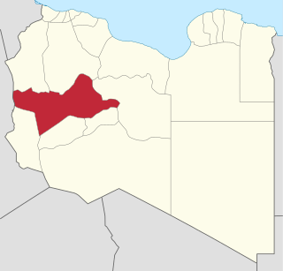
Wadi al Hayaa is one of the districts of Libya. Its capital is the city of Ubari. As of 2006, it had a population of 72,587, area of 31,890 square kilometres (12,310 sq mi) and a population density of 2.28 persons per square kilometer.

Wadi al Shati, sometimes referred to as Ashati, is one of the districts of Libya in the central-west part of the country. The area is mostly desert. Wadi al Shati District is named after the depression of the same name, Wadi Ashati.

Wadi el Kuf Bridge, is a bridge located 20 km west of Bayda, Libya. It is the second highest bridge in Africa.
Wadi-al-Ahmar, also known as Wadi-al-Hamra, is a place in Libya's Sirte District. In English, its name translates to "the red valley". Wadi-al-Ahmar is located just over 100km east of Sirte, the hometown of former Libyan leader Muammar Gaddafi and the capital of the Libyan Arab Jamahiriya remnants.
Protected areas of Libya include any geographical area protected for a specific use.

Wadi al-Far'a or Tirzah Stream is a stream in the northern West Bank that empties into the Jordan River south of Damia Bridge. It is the largest stream in the West Bank. Wadi al-Far'a is located in the rugged area of the West Bank and cuts east through the Jordan Valley, passing through the Palestinian village of Wadi al-Far'a. The Tirzah Reservoir is used to collect the floodwater of Wadi al-Far'a before it flows into the Jordan River.