Harris is the southern and more mountainous part of Lewis and Harris, the largest island in the Outer Hebrides, Scotland. Although not an island itself, Harris is often referred to in opposition to the Isle of Lewis as the Isle of Harris, which is the former postal county and the current post town for Royal Mail postcodes starting HS3 or HS5.

Knoydart is a peninsula in Lochaber, Highland, on the west coast of Scotland. Knoydart is sandwiched between Lochs Nevis and Hourn — often translated as "Loch Heaven" and "Loch Hell" respectively, although the somewhat poetic nature of these derivations is disputed. Forming the northern part of what is traditionally known as na Garbh-Chrìochan or "the Rough Bounds", because of its harsh terrain and remoteness, Knoydart is also referred to as "Britain's last wilderness". It is only accessible by boat, or by a 16-mile (26 km) walk through rough country, and the seven miles (11 km) of tarred road are not connected to the UK road system.

Ulva is a small island in the Inner Hebrides of Scotland, off the west coast of Mull. It is separated from Mull by a narrow strait, and connected to the neighbouring island of Gometra by a bridge. Much of the island is formed from Cenozoic basalt rocks, which are formed into columns in places.
Gometra is an island in the Inner Hebrides of Scotland, lying west of Mull. It lies immediately west of Ulva, to which it is linked by a bridge, and at low tide also by a beach. It is approximately 425 hectares in size. The name is also applied to the island summit, which is a Marilyn. The island has been owned since 1991 by Roc Sandford, a wealthy environmental campaigner who lives mostly in London and part of the year on Gometra.

The Kyles of Bute form a narrow sea channel that separates the northern end of the Isle of Bute from the Cowal peninsula in Argyll and Bute, on the Scottish mainland. The surrounding hillsides are roughly wooded, and overlooked by rocky tops and areas of moorland.

Loch Shiel is a freshwater loch situated 20 kilometres (12 mi) west of Fort William in the Highland council area of Scotland. At 28 kilometres long it is the 4th longest loch in Scotland, and is the longest to have retained a natural outflow without any regulation of its water level, being 120 m (393 ft) deep. Its nature changes considerably along its length, being deep and enclosed by mountains in the north east and shallow surrounded by bog and rough pasture in the south west, from which end the 4 km River Shiel drains to the sea in Loch Moidart near Castle Tioram.

Inch Kenneth is a small grassy island off the west coast of the Isle of Mull, in Scotland. It is at the entrance of Loch na Keal, to the south of Ulva. It is part of the Loch na Keal National Scenic Area, one of 40 in Scotland. It is within the parish of Kilfinichen and Kilvickeon, in Argyll and Bute.
Little Colonsay is an uninhabited island west of the island of the Isle of Mull in Scotland. The geology of the island is columnar basalt, similar to that of neighbouring Staffa. It is part of the Loch Na Keal National Scenic Area, one of 40 in Scotland.
Eorsa is an uninhabited island in the Inner Hebrides of Scotland.

Na h-Eileanan an Iar, formerly the Western Isles, is a constituency of the Scottish Parliament (Holyrood) covering the council area of Na h-Eileanan Siar. It elects one Member of the Scottish Parliament (MSP) by the first past the post method of election. It is also one of eight constituencies in the Highlands and Islands electoral region, which elects seven additional members, in addition to the eight constituency MSPs, to produce a form of proportional representation for the region as a whole.

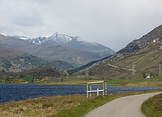
Loch Tummel is a long, narrow loch, seven kilometres northwest of Pitlochry in the council area of Perth and Kinross, Scotland. It is fed and drained by the River Tummel, which flows into the River Tay about 13 km (8 mi) south-east of the Clunie Dam at the loch's eastern end.
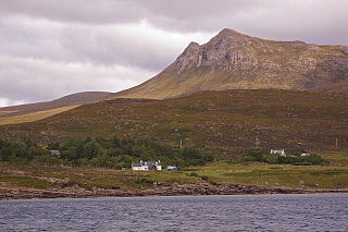
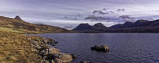
Coigach is a peninsula north of Ullapool, in Wester Ross in the Northwest Highlands of Scotland. The area consists of a traditional crofting and fishing community of a couple of hundred houses located between mountain and shore on a peninsula looking over the Summer Isles and the sea. The main settlement is Achiltibuie. Like its northerly neighbour, Assynt in Sutherland, Coigach has mountains which rise sharply from quiet, lochan-studded moorland, and a highly indented rocky coast with many islands, bays and headlands. The highest summit is Ben Mor Coigach at 743 metres; the distinctive profile of Stac Pollaidh is the other main peak within Coigach. The scenic qualities of Coigach, along with neighbouring Assynt, have led to the area being designated as the Assynt-Coigach National Scenic Area, one of 40 such areas in Scotland.
The island of Lunga is the largest of the Treshnish Isles in Argyll and Bute, Scotland. The Isles are part of the Loch Na Keal National Scenic Area.

Kintail is a mountainous area sitting at the head of Loch Duich in the Northwest Highlands of Scotland, located in the Highland Council area.
Glen Strathfarrar is a glen in the Highland region of Scotland, near Loch Ness.
Loch na Keal, meaning Loch of the Kyle, or Narrows, also Loch of the Cliffs, is the principal sea loch on the western, or Atlantic coastline of the island of Mull, in the Inner Hebrides, Argyll and Bute, Scotland. Loch na Keal extends over 20 kilometres (12 mi) inland, almost bisecting Mull, and extending to within 5 km (3 mi) of the eastern shore. The loch gives its name to the Loch na Keal National Scenic Area, one of forty national scenic areas in Scotland.

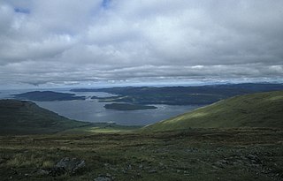
Ben Nevis and Glen Coe is a national scenic area (NSA) covering part of the Highlands of Scotland surrounding Ben Nevis and Glen Coe, in which certain forms of development are restricted. It is one of 40 such areas in Scotland, which are defined so as to identify areas of exceptional scenery and to ensure its protection from inappropriate development. The Ben Nevis and Glen Coe NSA covers 903 km2 (349 sq mi) of land, lying within the Highland, Argyll and Bute and Perth and Kinross council areas. A further 19 km2 (7.3 sq mi) of the NSA are marine, covering the sea loch of Loch Leven.

Elections to Comhairle nan Eilean Siar took place on 5 May 2022 on the same day as the 31 other Scottish local government elections. The election was the first to use the nine wards created under the Islands (Scotland) Act 2018 which allowed for single and dual member wards, with 29 councillors being elected. Each ward elected either 2, 3 or 4 members, using the Single Transferrable Vote electoral system, a form of proportional representation. Following a boundary review the number of wards will increase from nine to 11 while the number of councillors elected will fall from 31 to 29.

Loch Lurgainn is a large remote and deep freshwater loch with a crescent shape with its concave side turned to the south. It is located in the Coigach peninsula in Lochbroom, Wester Ross. Loch Lurgainn is located 8 miles north of Ullapool and two miles south of Loch Sionascaig and is 3.5 miles southeast of Enard Bay. The scenic qualities of Coigach, along with neighbouring Assynt, have led to the area being designated as the Assynt-Coigach National Scenic Area, one of 40 such areas in Scotland. The main settlement in the area, located directly to the north-west is Achiltibuie.
Loch Bad a' Ghaill is a small remote and deep freshwater loch that is located 10 miles north of Ullapool and immediately north west of Loch Lurgainn. It is located in the Coigach peninsula in Lochbroom, Wester Ross. The scenic qualities of Coigach, along with neighbouring Assynt, have led to the area being designated as the Assynt-Coigach National Scenic Area, one of 40 such areas in Scotland. The main settlement in the area, located directly to the north-west is Achiltibuie.