
Lincoln County is a county located in the U.S. state of Mississippi. As of the 2020 census, the population was 34,907. Its county seat is Brookhaven.

The Danville Micropolitan Statistical Area is a Micropolitan Statistical Area (μSA) in Virginia as defined by the United States Office of Management and Budget (OMB). As of the 2010 census, the μSA had a population of 106,561

The Greenwood Micropolitan Statistical Area is a micropolitan area in the northwestern Delta region of Mississippi that covers two counties - Leflore and Carroll. As of the 2000 census, the USA had a population of 48,716.

The Tupelo Micropolitan Statistical Area is a micropolitan area in northeastern Mississippi that covers three counties—Itawamba, Lee and Pontotoc. As of the 2000 census, the area had a population of 125,251. The population at the 2020 Census was 138,390.

The Laurel Micropolitan Statistical Area is a micropolitan statistical area (μSA) in southeastern Mississippi that covers two counties - Jasper and Jones. The 2010 census placed the Laurel micropolitan area population at 84,823, though as of 2019, estimates indicate the population has slightly decreased to 84,481.

The Natchez Micropolitan Statistical Area is a micropolitan area that consists of Adams County, Mississippi and Concordia Parish, Louisiana. As of the 2000 census, it had a population of 54,587.

The Meridian Micropolitan Statistical Area is a micropolitan area in east central Mississippi that covers two counties - Clarke and Lauderdale. As of the 2000 census, the μSA had a population of 106,569. According to the 2010 Census, the population is of 107,449.

The Kingsville Micropolitan Statistical Area is a micropolitan area in South Texas that covers one sole county–Kleberg. The micropolitan statistical area also included Kenedy County which was detached in 2023. It is also part of the larger Corpus Christi–Kingsville–Alice Combined Statistical Area.

The Scottsbluff Micropolitan Statistical Area, as defined by the United States Census Bureau, is an area consisting of three counties in Nebraska, anchored by the city of Scottsbluff.
The Ontario Micropolitan Statistical Area, as defined by the United States Census Bureau, is an area consisting of two counties – one in southeastern Oregon and one in southwestern Idaho, anchored by the city of Ontario.

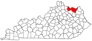
The Frankfort Micropolitan Statistical Area, as defined by the United States Census Bureau, is an area consisting of two counties in central Kentucky, anchored by the city of Frankfort. As of the 2000 census, the Micropolitan Statistical Area (μSA) had a population of 66,798.

The Enterprise–Ozark Micropolitan Statistical Area, as defined by the United States Census Bureau, was an area consisting of two counties in southeastern Alabama, anchored by the cities of Enterprise and Ozark. As of the 2000 census, the μSA had a population of 92,744.
The Mount Sterling Micropolitan Statistical Area, as defined by the United States Census Bureau, is an area consisting of three counties in Kentucky, anchored by the city of Mount Sterling. As of the 2000 census, the μSA had a population of 40,195.

The Muscatine Micropolitan Statistical Area, as defined by the United States Census Bureau, is an area consisting solely of Muscatine County and anchored by the city of Muscatine. The Muscatine Micropolitan Statistical Area is also a part of the Quad Cities Iowa–Illinois Combined Statistical Area (CSA), which has a population of 474,226, making it the 90th-largest CSA in the nation.
The Maysville Micropolitan Statistical Area (μSA), as defined by the United States Census Bureau, is coterminous with Mason County, Kentucky, whose county seat and largest city is Maysville. As of the 2010 census, the population of Mason County and the current μSA was 17,490, and 2014 Census Bureau estimates place the population at 17,166.

The Hope Micropolitan Statistical Area, as defined by the United States Census Bureau, is an area consisting of two counties in the U.S. state of Arkansas, anchored by the city of Hope.

The Martinsville Micropolitan Statistical Area is a United States Micropolitan Statistical Area (USA) in Virginia, as defined by the Office of Management and Budget (OMB) as of June, 2003. As of the 2000 census, the μSA had a population of 73,346.
The Jasper micropolitan statistical area, as defined by the United States Census Bureau, is an area consisting of one county in southwestern Indiana, anchored by the city of Jasper. At the 2020 census, the Micropolitan area (μSA) had a population of 43,637 up from a population of 41,889 in the 2010 census. In previous statistical definition updates, the area also included Pike County which was removed in the 2023 updates.

The New Orleans–Metairie–Slidell combined statistical area is made up of nine parishes in southeastern Louisiana and one county in Mississippi. The statistical area consists of the New Orleans metropolitan statistical area (MSA), Slidell–Mandeville–Covington, LA MSA, Picayune micropolitan statistical area (μSA), and the Bogalusa μSA. As of the 2020 census estimates, the CSA had a population of 1,510,672. In 2023, the Office of Management and Budget updated the Core Based Statistical Areas, removing St. Tammany Parish from the New Orleans–Metairie MSA to create the Slidell–Mandeville–Covington MSA.

The Dublin micropolitan statistical area, as defined by the United States Census Bureau, is an area consisting of two counties in Georgia, anchored by the city of Dublin.

